Kashafrud river - رودخانه کشف رود
اینجا درباره رودخانه کشفرود ایران مینویسمKashafrud river - رودخانه کشف رود
اینجا درباره رودخانه کشفرود ایران مینویسمدرباره من
 از اونهام که می گم آدم بایست حرف خودشو بزنه، اما یاد گرفتم که هر حرفی رو تو جاش بزنم، اینجا، هرچی می خوام رو می گم
ادامه...
از اونهام که می گم آدم بایست حرف خودشو بزنه، اما یاد گرفتم که هر حرفی رو تو جاش بزنم، اینجا، هرچی می خوام رو می گم
ادامه...
پل چشمه گیلاس کشفرود
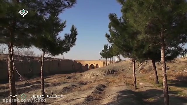
پل چشمه گیلاس بر روی رودخانه کشفرود و نزدیک تپه قادرآباد قرار دارد. این پل از دیرباز به سبب تاج های بلندش در معماری ایرانی مورد توجه قرار داشته است. پل «چشمه گیلاس» را به این دلیل به این نام نهاده اند که نزدیکی روستای «چشمه گیلاس» و چشمه ای به این نام قرار دارد. تمدن تاریخی در گذشته در کنار این رودخانه شکل گرفته بود، و روستایی که نزدیک این چشمه قرار داشته با درختان انبوه گیلاس شهرت یافته است. درختان انبوه گیلاس به زیبایی منطقه می افزوده و ذوق معماری آن منطقه را شکوفا میکرده است.
دیوارهای تاریخی آجری از محل همین پل و در امتداد رودخانه اساطیری کشفرود (کاسه رودخانه) آغاز می شود و امروز شکوه آجری آن را با بیست و هشت متر طول و پنج متر پهنا میبینید. بلندای آن از کف دره بین هشت تا ده متر است.
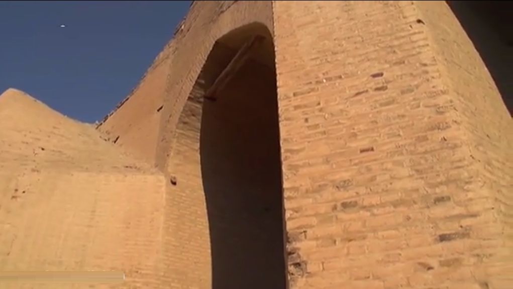
آن بخش از دیواره پل که طاق بلندی ساخته شده داستانی روایت گر دارد. از سمت پل که بالاتر و به سمت چشمه گیلاس برویم سایر بقایای تاریخی چند هزار ساله را که در کنار رودخانه شکل گرفته بودند می بینیم. آثاری همچون تپه قادرآباد از آن جمله است.
این پل که امروزه میزبان مهمانان بسیاری است، باعث کوتاهشدن مسیر مسافرانی میشود که از سمت مشهد قصد مسافرت به شهرهای چناران و قوچان در ایران را دارند.
رودخانه کشفرود جاذبه گردشگریست که در مسیر آرامگاه فردوسی قرار دارد. در مسیر آن پلی قرار دارد به نام پل فردوسی که بزرگ و ساده است.
عکس پل فردوسی کشفرود:
_qmj9.jpg)
آدرس دقیق پل فردوسی:
خراسان رضوی، بلوار شاهنامه، میدان سپهبد، رودخانه کشفرود (کشف رود)
آدرس پل چشمه گیلاس: بلوار شاهنامه، تپه قادرآباد، قره جنگل، روستای چشمه گیلاس
__________________
The Cherry Spring Bridge is located on the Kashafrud River and near Qaderabad Hill. This bridge has long been noted in Iranian architecture due to its tall crowns. The “Cherry Spring” bridge was named so because it is located near the village of “Chishmeh Gilas” and a spring of this name. Historical civilization was formed along this river in the past, and the village that was located near this spring became famous for its dense cherry trees. The dense cherry trees added to the beauty of the area and flourished the architectural taste of that area.
Historical brick walls begin from the site of this bridge and along the mythical Kashafrud River (the bowl of the river), and today you can see its brick splendor with twenty-eight meters long and five meters wide. Its height from the valley floor is between eight and ten meters.
That part of the bridge wall where the high arch is built tells a story. From the bridge, going higher and towards the Cherry Spring, we see other historical remains that were formed by the river thousands of years ago. Such monuments as the Qaderabad Hill are among them.
This bridge, which hosts many guests today, shortens the route for travelers who plan to travel from Mashhad to the cities of Chenaran and Quchan in Iran.
The Kashafrud River is a tourist attraction located on the way to Ferdowsi's tomb. On its way, there is a bridge called the Ferdowsi Bridge, which is large and simple.
Photo of the Ferdowsi Bridge, Kashfrud:
Exact address of the Ferdowsi Bridge:
Khorasan Razavi, Shahnameh Boulevard, Sepahbod Square, Kashfrud River (Kashafrud)
Address of the Cherry Spring Bridge: Shahnameh Boulevard, Qaderabad Hill, Qara Jangal, Cheshme Gilas Village
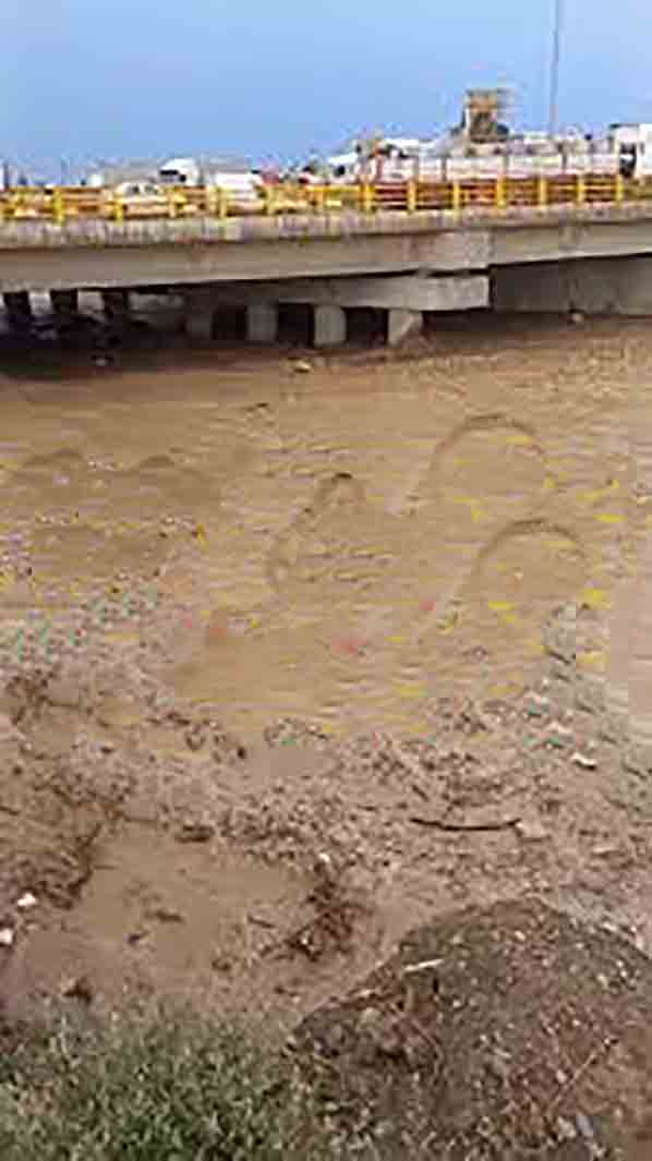
کشفرود، باهوکلات و ایرانرود
با گسترش صنایع گازی و آبی در دهه نود حوضه آبی شهرهای ساحلی جنوبی کشور، از جمله چابهار یکی از جالبترین مناطق ایران برای اهالی شمال شرقی شده است.
کشفرود و باهوکلات
زمین سرد و خشک کشفرود در مقایسه با زمین نمناک و پر شرجی باهوکلات؛ کشفرود با بوته های آن و باهوکلات با درختان سبزی چون گز در ایران.
کشفرود: جایی که سال گذشته کم باران بود و جایی نزدیکی باهوکلات سیل آمد.
باهوکلات، که به رودخانه باهو ، رود دشتیاری و رود سیلوپ نیز معروف است، رودخانهای در استان سیستان و بلوچستان در ایران است ، و در منطقه باهو واقع شده، که در حدود ۹۰ کیلومتری شهرستان چابهار است.
در حوضه آبریز باهوکلات زمین های اطراف، حتی با وجود سیمان کردن آب دارند. در کشفرود ۱۹۴ کیلومتری جایی بی آبی است و جایی فراوانی آب منجر به سیل، که هر دو مصیبت اند. در حوضه آبریز باهوکلات سیلاب های بزرگ ممکن است در زندگی روستایی خالی ایجاد کند، و مانعی بر سر راه کشاورزی شود. در باهوکلات سطح آب که زیاد بالا برود خانه ها را سیل فرا میگیرد. مارهای سمی در انتظار کودکان و جانوران اهلی کمین میکنند. مزرعه های کتان و برنج بر کرانه های آبرفتی را قبل از برداشت محصول آب میگیرد، و دامها باید به مناطق خشک تر برد. به جبران این، آب که عقب نشست کرانه های رودخانه از ماده ای آلی پوشیده شده است که باروری خاک را افزایش میدهد.
در حوضه باهوکلات برخلاف کشفرود از تشنگی خبری نیست، ولی در فصل سیل مردم روستا گرسنگی میکشند. سطح آب که بالا می آید ماهی ها رودخانه را ترک میکنند و به مرداب ها و به دریاچه ها میروند. در حوزه حیات وحش آن نیز تمساح پوزه کوتاه برجستهترین موجود منطقه چابهار است که به طور طبیعى و آزاد زندگى میکند.
تالاب صورتی چابهار

نکته جالب اینجاست که تالاب صورتی چابهار به خاطر وجود گیاه پنبه وحشی در میان گردشگران و بومیان منطقه شناخته شده است. بسیاری از بومیان با برداشت این گونه گیاهی، به تهیه لحاف و بالش میپردازند.
ایران رود
صنعت آبراه و کانال های آبی صنعت نوینی است که با پروژه ایرانرود در بستر خشک شده رودخانههای شرق کشور تعریف میشود. ایرانرود طرحی است که بیش از نیم قرن به طور جدی پیشنهاد شده و فراهم آوردن نزدیک به 2 میلیون شغل در ایران را به دنبال دارد. این طرح که قدمت ارائه آن به دوره باستانی هخامنشیان باز میگردد، تولید و دستیابی به آب آشامیدنی، فراهم آوردن راههای آبرسانی و مبارزه با خشکسالی را در پی دارد.
از مزایای این طرح آبرسانی به فلات مرکزی ایران است.
سابقه اجرای کانال آبرسانی مانند ایرانرود را در کشورهای مختلف از جمله کره جنوبی و آمریکا میتوان یافت، که همچنان در حال توسعه هستند. نمونه آن کانال پاناما است.
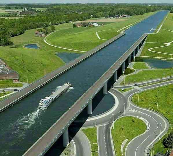
از آنجاییکه کانال پاناما ظرفیت کشتیهای با حداکثر 65000 تن کالا را دارد در حالیکه کشتیهای بزرگ باربری نوین میتوانند تا 300000 تن کالا را حمل نمایند ، مدتی است که سخن از ساختن آبراه تازه ای در همان منطقه یا در نیکاراگوا و یا مکزیک میشود.
نکته قابل تعمق اینست که اندیشه اینگونه برنامه های بزرگ در هر دوران چندین و چندبار مورد بحث و گفتگو قرار گرفته و از سوی بسیاری از بدگمانان و حتی متخصصین مورد حمله و حتی استهزا قرار گرفته و غیر قابل انجام و رویایی نامیده شده بود ولی با بهره گیری از نیروی اندیشه انسانی و پشتکار این پروژه ها جامه عمل پوشیده و برای همیشه چهره زمین را دگرگون ساخته اند.
سایر مزایای ایرانرود
پدید آوردن امنیت و کمک به مبارزه با قاچاق مواد مخدر
استقرار نیروی انتظامی در سراسر آبراه، ایجاد گارد دریایی، حمل و نقل کشتی رانی و حضور دائمی صنایع مختلف، امنیت را به سطح بالایی رسانده و کمک بزرگی در راه مبارزه با قاچاق مواد مخدر خواهد بود. این امر مورد ستایش کشورهای اروپایی غربی که شدیداً نگران حمل این مواد از پاکستان و افغانستان به کشورهای خود هستند قرار گرفته و همچنین با قدرشناسی سازمان ملل متحد روبرو خواهد شد. بدین ترتیب میتوان از آنان انتظار همکاری در فراهم آوردن بودجه برای ساختن این آبراه را داشت. همچنین پرورش آبزیهای دریای خزر، از جمله خاویار، در یک دریاچه ایجاد شده از آب تالابچه های بالابرنده های کشتی ها در یک سوی آبراه و آبزیهای خلیج فارس در سوی دیگر و ارائه آنها با بازارهای داخلی و بین المللی، درآمد سرشار پایداری برای ایران بدست خواهد داد.
ایرانرود طرحی از زمان هخامنشیان
در دانشنامه طبس گلشن آمده است:
بنا به گفته هرودوت: «بیشتر آسیا را داریوش بزرگ اکتشاف کرده بود. در آنجا رودخانهای است به نام سند که در آن نهنگ (تمساح) فراوان وجود دارد و تنها یک رودخانه در روی زمین (رود نیل) بیش از آن نهنگ دارد. داریوش که میخواست بداند سند از کجا سرچشمه میگیرد و در کجا به دریا میریزد، کشتیهایی را به سرپرستی اسکیلاکس دریانورد هخامنشی و مردان دیگری را که به راستگویی آنان اعتماد داشت، در پی این کار فرستاد. پس از این اکتشاف دریایی داریوش بزرگ، هندیان را تحت فرمان خود درآورد و آن دریا را در قلمرو ایران قرار داد. به این ترتیب معلوم شد که آسیا به جز بخشهایی که در طرف برآمدن خورشید است، از جهات دیگر به آفریقا (Libya) شباهت دارد». از این قرار، اسکیلاکس دریانورد هخامنشی، در زمان پادشاهی داریوش نخست (پادشاه ایران از ۵۲۱ تا ۴۸۵پم) معروفیت و شهرت یافتهاست. در سال ۳۴۸ تا ۳۶۰ پم، کتاب مسافرت دور دریایی اسکیلاکس (Periplus of Scylax) نوشته شده که در آن شرح گشتهای دریایی اسکیلاکس دریانورد، از جمله این مسافرت به تفضیل آورده شدهاست، اما، نکته بسیار جالب در این کتاب، ادامه مسافرت اسکیلاکس دریانورد است. او از خلیج پارس به راه میافتد، و دریای هند را طی میکند، به سوی سرچشمه رودخانه سند رفته، از آنجا سرچشمه رودخانه جیحون (Oxus) را مییابد، از رودخانه جیحون به سمت دریای مازندران ره میسپارد. رودخانه جیحون تا سال ۱۵۵۰ میلادی (۹۲۹ خورشیدی) به دریای مازندران میریخته و دو دریاچه وخش (آرال) و مازنداران به یکدیگر مربوط بودهاند. امروزه محل پیوند این دو دریاچه، گودالی به نام (آقچهبایا) با ژرفنای ۸۲- متر، پایینتر از سطح دریا قرار گرفتهاست. ارسطو در نوشتههای خود به این کتاب و این سفردریایی و این آبراهه اشاره نموده، خواندن آن را جزو وظایف شاگرد خود، اسکندر مقدونی، قرار داد. پولوبیوس (۱ پم) و استرابون (۱ پم) هم شرح این سفر دریایی و این آبراهه را در نوشتههای خود آوردهاند. مطالب این کتاب از جمله سفر دریایی از خلیج پارس به دریای مازندران، توسط دانشمندان معاصر، افسانه آمیز تلقی شد، تا اینکه، در سال ۱۹۵۷ میلادی (۱۳۳۶ خورشیدی) دانشمندان شوروی سابق بقایای حفاری یک ترعه، مربوط به زمان هخامنشیان، در سرچشمههای ایندو رود را پیدا کردند. این کشف باعث توجه دوباره دانشمندان به داستان این کتاب بود. با توجه به حفر کانال سوئز میان دریای سرخ و رودخانه نیل در مصر، در زمان داریوش بزرگ، و حفر کانال آتوس در زمان خشایارشا، در یونان، میتوان انگاشت که اندیشمندان و فرزانگان ایرانی به ضرورت ایجاد یک راه آبی که دریاهای شمال و جنوب ایران را به یکدیگر پیوند بزند، پی برده بودند. ایرانیان ۲۵ قرن پیش دریای مازندران و خلیج پارس را به یکدیگر پیوند زده بودند.
_________________
With the expansion of gas and water industries in the 2010s, the watershed of the southern coastal cities of the country, including Chabahar, has become one of the most interesting areas of Iran for the people of the northeast.
Kashafrud and Bahuklat
The cold and dry land of Kashfrud compared to the humid and swampy land of Bahuklat; Kashfrud with its bushes and Bahuklat with green trees such as Gaz in Iran.
Kashfrud: Where there was little rain last year and a place near Bahuklat flooded.
Bahuklat, also known as the Bahu River, Dashtiari River, and Silop River, is a river in Sistan and Baluchestan Province in Iran, and is located in the Bahu region, which is about 90 kilometers from Chabahar city.
In the Bahuklat watershed, the surrounding lands have water, even despite being cemented. In the 194-kilometer Kashfrud, there is a lack of water in some places and an abundance of water in others leads to flooding, both of which are disasters. In the Bahuklat basin, major floods can wreak havoc on rural life and hinder agriculture. In Bahuklat, when the water level rises too high, houses are flooded. Venomous snakes lie in wait for children and domestic animals. Cotton and rice fields on alluvial banks are flooded before harvest, and livestock must be moved to drier areas. To compensate, the receding water covers the riverbanks with organic matter that increases soil fertility.
Unlike Kashfarud, there is no thirst in the Bahuklat basin, but during the flood season, villagers go hungry. When the water level rises, fish leave the river and go to the marshes and lakes. In terms of wildlife, the short-nosed crocodile is the most prominent creature in the Chabahar region, living naturally and freely.
Chabahar Pink Wetland
An interesting point here is that Chabahar Pink Wetland is known among tourists and locals for the presence of wild cotton plants. Many locals harvest this plant to make quilts and pillows.
Iran Rud
The waterway and water canal industry is a new industry that is defined by the Iran Rud project in the dried-up riverbeds of the eastern part of the country. Iran Rud is a plan that has been seriously proposed for more than half a century and aims to provide nearly 2 million jobs in Iran. This plan, which dates back to the ancient Achaemenid period, aims to produce and access drinking water, provide water supply routes, and combat drought.
One of the benefits of this plan is the water supply to the central plateau of Iran.
Iran Rud - via Sistan and Baluchestan
The history of implementing water supply canals like Iran Rud can be found in various countries, including South Korea and the United States, which are still under development. An example of this is the Panama Canal.
Highway River - Bridge at Unlevel Intersection
Since the Panama Canal has a capacity of ships with a maximum of 65,000 tons of goods, while large modern cargo ships can carry up to 300,000 tons of goods, there has been talk for some time of building a new waterway in the same region or in Nicaragua or Mexico.
The point to ponder is that the idea of such large programs has been discussed and discussed many times in every era and has been attacked and even ridiculed by many skeptics and even experts and called unfeasible and a dream, but by utilizing the power of human thought and perseverance, these projects have become reality and have changed the face of the earth forever.
Other benefits of IranRood
Providing security and helping to fight drug trafficking
The deployment of law enforcement forces throughout the waterway, the establishment of a marine guard and the permanent presence of these forces will raise security to a high level and will be a great help in the fight against drug trafficking. This has been praised by Western European countries, which are very concerned about the transportation of these materials from Pakistan and Afghanistan to their countries, and will also be appreciated by the United Nations. Thus, they can be expected to cooperate in providing funds for the construction of this waterway. Also, the cultivation of Caspian Sea aquatic animals, including caviar, in a lake created from the water of the ship lift ponds on one side of the waterway and the aquatic animals of the Persian Gulf on the other and providing them to domestic and international markets will provide Iran with a rich and sustainable income.
Iran River A plan from the Achaemenid era
Country elevation map - Iran River route
The Tabas-Golshan Encyclopedia states:
According to Herodotus: “Most of Asia was explored by Darius the Great. There is a river called the Indus in which there are many whales (crocodiles) and only one river on earth (the Nile) has more whales. Darius, who wanted to know where the Indus River originated and where it flowed into the sea, sent ships under the command of the Achaemenid navigator Scylax and other men whose truthfulness he trusted, to do this. After this maritime discovery, Darius the Great brought the Indians under his command and placed that sea in the territory of Iran. In this way, it was found that Asia, except for the parts on the rising sun, is similar to Africa (Libya) in other respects. Thus, Scylax, the Achaemenid navigator, became famous and famous during the reign of Darius I (King of Iran from 521 to 485 BC). In 348 to 360 BC, the book of Scylax's sea voyages (Periplus of Scylax) was written, in which the description of Scylax's sea voyages, including this voyage, is given in detail. However, the most interesting thing in this book is the continuation of Scylax's voyage. He sets out from the Persian Gulf, and crosses the Indian Ocean, goes to the source of the Indus River, from there he finds the source of the Oxus River, and from the Oxus River he heads towards the Caspian Sea.
. The Jihun River flowed into the Caspian Sea until 1550 AD (929 AD), and the two lakes Vakhsh (Aral) and Mazandaran were connected. Today, the junction of these two lakes is a pit called (Aqche Baya) with a depth of -82 meters, located below sea level. Aristotle mentioned this book, this voyage, and this waterway in his writings, and made reading it one of the duties of his student, Alexander the Great. Polybius (1 BC) and Strabo (1 BC) also described this voyage and this waterway in their writings. The contents of this book, including the voyage from the Persian Gulf to the Caspian Sea, were considered legendary by contemporary scientists, until, in 1957 AD (1336 AD), scientists from the former Soviet Union found the remains of a trench excavation dating back to the Achaemenid era at the sources of the Indus River. This discovery brought renewed attention to the story of this book. Considering the digging of the Suez Canal between the Red Sea and the Nile River in Egypt, during the time of Darius the Great, and the digging of the Athos Canal during the time of Xerxes, in Greece, it can be assumed that Iranian thinkers and sages had realized the necessity of creating a waterway that would connect the northern and southern seas of Iran. The Iranians had connected the Caspian Sea and the Persian Gulf 25 centuries earlier.
ورزش های بومی سنتی کشفرود
کشتی با چوخه؛ افتخار ورزشهای بومی در دل کشفرود
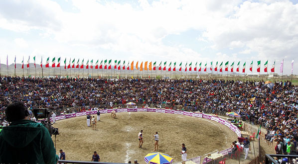
در اردیبهشتماه سال جاری، چهارمین دوره مسابقات کشتی با چوخه در روستای آلماجق با حضور علاقهمندان به ورزشهای بومی و سنتی برگزار شد. این رقابتها که نمادی از فرهنگ و سنت اصیل منطقه شمال خراسان است، بار دیگر جایگاه ویژه کشتی چوخه را در میان مردم و ورزشدوستان به نمایش گذاشت.
در وزن ۸۴ کیلوگرم این رقابتها، علی زحمتکش از مشهد موفق به کسب مقام نخست شد. امیرحسین کمایستانی از جوین مقام دوم را از آن خود کرد و پوریا قلیزاده از اسفراین نیز به مقام سوم دست یافت.
این رویداد نهتنها یک رقابت ورزشی، بلکه بهانهای بود برای بازنگری و معرفی ورزشها و بازیهای بومی و سنتی منطقه کشفرود که ریشه در فرهنگ غنی و تاریخ کهن این سرزمین دارد.
ورزشهای بومی و سنتی در منطقه کشفرود
در شهر توس، در کنار پل تاریخی فردوسی، گود مخصوص کشتی قرار دارد؛ نشانهای روشن از جایگاه مهم کشتی چوخه در زندگی اجتماعی مردم این ناحیه. اما کشفرود تنها محدود به کشتی نیست. از بازیهای محلی تا ورزشهای آبی، این منطقه تنوع کمنظیری در حوزه ورزشهای بومی دارد.
بازیهای محلی:
1. آفتاب مهتاب:
بازیای شاد و پرتحرک که در میان کودکان و نوجوانان محبوبیت دارد. در این بازی، دو نفر پشت به پشت میایستند، دستها را در هم قفل میکنند و با فرمان «آفتاب» یا «مهتاب» یکی از بازیکنان نفر دیگر را سوار بر پشت خود میکند و بازی ادامه مییابد.
2. اوستا سلامی:
یک بازی گروهی قدیمی و ریشهدار که بدون نیاز به ابزار خاص انجام میشود. یکی از بازیکنان با خم شدن در نقش «اوستا» قرار میگیرد و دیگران با طرح سوالاتی طنزآمیز مانند «آش جو خورده با ماس و خیار، عامو یادگار خوابی یا بیدار؟» سعی در شناخت وضعیت «اوستا» دارند. این بازی ترکیبی از شوخطبعی، حرکت و مشارکت گروهی است.
ورزشهای آبی:
رفتینگ در کشفرود:
رفتینگ، یا قایقسواری گروهی در آبهای متلاطم، یکی از محبوبترین تفریحات آبی منطقه کشفرود به شمار میآید. این ورزش در بخش میانی شهر، بهویژه در ایام گرم سال، گردشگران زیادی را به خود جذب میکند. استفاده از قایقهای بادی و هماهنگی گروهی با هدایت یک لیدر از ویژگیهای این فعالیت هیجانانگیز است.
سایر بازیها:
3. هفت سنگ:
از بازیهای قدیمی و پرطرفدار که در میان کودکان و نوجوانان رایج است. بازیکنان در دو گروه تقسیم شده و با هدف زدن هفت سنگ رویهم چیدهشده با توپ، مهارت و تمرکز خود را محک میزنند.
4. طنابکشی:
یکی از بازیهای اصیل و گروهی که در مراسم محلی، جشنها و روزهای ملی برگزار میشود و همزمان نیروی جسمانی، انسجام تیمی و هیجان را به نمایش میگذارد.
5. کشتی با چوخه:
استان پهلوان خیر خراسان و سرزمین نوادگان سربداران، مصفی به وجود پربرکت حرم مطهر حضرت رضا علیه السلام، اسوه تقوا و مردانگی و هشتمین امام شیعیان می باشد.
کشتی خاص این استان کشتی «باچوخه» است که بیشتر در نواحی قوچان، بجنورد، اسفراین، فریمان و چناران رایج است.
با چوخه برای علاقمندان به کشتی، نام آشنایی است. چراکه این ورزش، بلند پایگانی در کسوت پهلوانی و قهرمانی داشته و دارد.
در این کشتی ورزشکاران از لباس خاصی استفاده میکنند که عبارتست از:
شلواری مخصوص که تا زانو میباشد و در صورت عدم دستیابی به این شلوار از شلوار محلی بلند استفاده کرده، ولی پاچه های آن را در آغاز کشتی تا زانو بالا میزنند. دوم روپوش مخصوصی به نام چوخه دارد که قدری بلندتر از کت بوده و فاقد آستین میباشد و جنس آن از بافته های پشمی و نخی محکم است. سوم، پارچه ای به نام «شال» دارد که به کمر بسته میشود.
مدت زمان مبارزه ده دقیقه بدون توقف است. چنانچه در این فاصله کشتی به نتیجه نرسد، با دو دقیقه استراحت، مبارزه برای پنج دقیقه دیگر ادامه پیدا میکند.
در این کشتی از فنونی چون یک خم و گرفتن از زانو به پایین که ممنوع است، نمی توان استفاده کرد. همچنین این کشتی پل ندارد و چنانچه شانه حریف در جریان مبارزه بر زمین سایه اندازد بازنده خواهد بود. شگرد خاص این نوع کشتی فن لِنگ میباشد. قضاوت این ورزش را پیشکسوتان با چوخه برعهده دارند و بنابر عرف و رسم محلی جایزه پهلوانی که حریف خود را به زمین بزنند، یک راس قوچ است.
چشمانداز جهانی برای ورزشهای سنتی
به گفته سرپرست هیأت بازیهای بومی و محلی، این ورزشها ظرفیت بالایی برای جذب گردشگر داخلی و خارجی دارند. او افزود:
«در آیندهای نزدیک، تیمی متشکل از کشتیگیران سنتی و محلی از استانهای کردستان، کرمانشاه و ایلام برای شرکت در مسابقات کشتی محلی (زوران) به کشور عراق اعزام خواهند شد. این اتفاق، فرصتی ارزشمند برای معرفی فرهنگ و رسوم منطقه به جهان و گامی مهم در مسیر توسعه گردشگری فرهنگی خواهد بود.»
____________
Wrestling with a Chokhe; The Pride of Native Sports in the Heart of Kashafrud
Wrestling with a Chokhe - Traditional Native Kashafrud
In May of this year, the fourth edition of the wrestling with a chokhe competition was held in the village of Almajaq with the presence of enthusiasts of native and traditional sports. This competition, which is a symbol of the authentic culture and tradition of the North Khorasan region, once again demonstrated the special place of chokhe wrestling among the people and sports enthusiasts.
In the 84 kg weight category of this competition, Ali Zahmatkesh from Mashhad won first place. Amirhossein Kamayistani from Jovein took second place, and Pouria Gholizadeh from Esfarayen also won third place.
This event was not only a sports competition, but also an excuse to review and introduce the native and traditional sports and games of the Kashfrud region, which are rooted in the rich culture and ancient history of this land.
Local and traditional sports in the Kashfrud region
In the city of Toos, next to the historic Ferdowsi Bridge, there is a special wrestling pit; a clear sign of the important place of the Chokheh wrestling in the social life of the people of this region. But Kashfrud is not limited to wrestling alone. From local games to water sports, this region has an unparalleled diversity in the field of local sports.
Local games:
1. Moonlight Sun:
A happy and dynamic game that is popular among children and adolescents. In this game, two people stand back to back, lock hands, and with the command "Sun" or "Moonlight", one of the players puts the other on his back and the game continues.
2. Avesta Salami:
An old and deep-rooted group game that is played without the need for special tools. One of the players bends down to play the role of "Avesta" and the others ask humorous questions such as "Ash-e-Jo Khorde with Mas and Khiyar, Amo Yadgar, are you asleep or awake?" They try to understand the state of the "Avesta". This game is a combination of humor, movement and group participation.
Water sports:
Rafting in Kashfrud:
Rafting, or group boating in turbulent waters, is one of the most popular water activities in the Kashfrud region. This sport attracts many tourists in the central part of the city, especially during the hot season. The use of inflatable boats and group coordination under the guidance of a leader are features of this exciting activity.
Other games:
3. Haft Sang:
An old and popular game that is common among children and adolescents. Players are divided into two groups and test their skills and concentration by hitting seven stones stacked on top of each other with a ball.
4. Tug of war:
One of the original and group games that is held in local ceremonies, celebrations and national days and at the same time demonstrates physical strength, team cohesion and excitement.
5. Wrestling with Chokheh:
The province of Khorasan, the hero of the good and the land of the descendants of the Sarbedaran, is blessed with the blessed presence of the Holy Shrine of Imam Reza (AS), the model of piety and manliness and the eighth Imam of the Shiites.
The special wrestling of this province is the "Bachokhe" wrestling, which is more common in the areas of Quchan, Bojnourd, Esfarayen, Fariman and Chenaran.
Chokheh is a familiar name for wrestling enthusiasts. Because this sport has and has a long history in the guise of heroism and heroism.
In this wrestling, athletes use special clothes, which include:
Special pants that are knee-length, and if these pants are not available, long local pants are used, but their legs are raised to the knee at the beginning of the wrestling. The second has a special cloak called a chokhe, which is slightly longer than a coat and has no sleeves, and is made of strong wool and cotton. The third has a cloth called a "shawl" that is tied around the waist.
The duration of the fight is ten minutes without stopping. If the fight does not result in this interval, the fight continues for another five minutes with a two-minute break.
In this fight, techniques such as a bend and a knee-down hold, which are prohibited, cannot be used. Also, this fight does not have a bridge, and if the opponent's shoulder falls on the ground during the fight, he will lose. The special technique of this type of fight is the fan lang. The referees of this sport are elders with a chokhe, and according to local customs and traditions, the prize for the champion who knocks his opponent to the ground is a ram's head.
Global outlook for traditional sports
According to the head of the board of indigenous and local games, these sports have a high potential to attract domestic and foreign tourists. He added: "In the near future, a team of traditional and local wrestlers from Kurdistan, Kermanshah and Ilam provinces will be sent to Iraq to participate in local wrestling competitions (Zoran). This event will be a valuable opportunity to introduce the culture and customs of the region to the world and an important step towards the development of cultural tourism."
پل خلیج فارس کشفرود
پاپیروس و نام خلیج فارس؛ پلی میان تاریخ و هویت
پاپیروس (帕皮鲁斯) یکی از نخستین بسترهای نگارش در تاریخ بشر است که در دوره باستان از آن برای ثبت رویدادها، اسناد حکومتی و متون علمی و مذهبی بهره میبردند. در منابع تاریخی، چینیها را مخترع کاغذ به سبک مدرن میدانند؛ کاغذی که با استفاده از خمیر بامبو ساخته میشد از طریق جاده ابریشم به نقاط مختلف دنیا صادر میشد. این کاغذ با نام پاپیروس بهعنوان یکی از کهنترین واسطههای مکتوب بشری همچنان جایگاهی نمادین دارد.
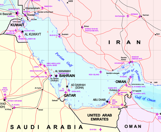
با الهام از همین نماد کهن، واژه "پاپیروس" را در کنار "خلیج فارس" جستوجو کردم؛ ترکیبی که نشانگر پیوندی میان تاریخ، تمدن و هویت ایرانی است. اما با کمال تعجب، بخش خبری اینترنت از چنین ترکیبی خالی بود. از همینرو، برای غنیسازی این حوزه، تصمیم گرفتم پلی کمتر شناختهشده اما باارزش را معرفی کنم: پل خلیج فارس کشفرود.
_wm01.jpg)
پل خلیج فارس کشفرود؛ پلی تاریخی میان طبیعت، فرهنگ و هویت
پل خلیج فارس کشفرود یک سازه تاریخی سنگی است که با چهار دهانه، در دل طبیعت خراسان رضوی خودنمایی میکند. این پل در موقعیتی راهبردی میان بزرگراه پیامبر اعظم و منطقه گردشگری شاندیز قرار گرفته و نقش پیونددهندهی مهمی میان بخشهای گردشگری، فرهنگی و طبیعی منطقه ایفا میکند.
از یکسو، این پل مجموعه ورزشی ثامنالائمه، پارک جنگلی سوران و باغهای میوهی طرقبه و شاندیز را به یکدیگر و بزرگراه پیامبر اعظم متصل میسازد؛ و از سوی دیگر، دسترسی مستقیم به شهر تاریخی توس را فراهم میآورد—شهری که با آثار ارزشمندی چون آرامگاه فردوسی، دیوار تاریخی توس، موزه نان و پل تاریخی فردوسی کشفرود، تجلیگاه فرهنگ و هویت ایرانی است.
ویژگی شاخص این پل، همگونی و هماهنگیاش با طبیعت اطراف است. رنگ و بافت سنگهای بهکاررفته در سازه، یادآور سنگهای بستر رودخانه شاندیز است که اغلب از جنس میکاشیست هستند؛ سنگهایی با درخشش طبیعی و طرحهایی لایهلایه که در نور روز جلوهای چشمنواز به پل میبخشند.
پلی از جنس تاریخ، طبیعت و آینده
_0iqe.jpg)
پل خلیج فارس کشفرود تنها یک گذرگاه نیست؛ بلکه نمادی از پیوند میان میراث تاریخی ایران، طبیعت بکر خراسان و تلاش برای توسعه گردشگری پایدار است. شاید امروز نام این پل کمتر شنیده شده باشد، اما بیشک در آینده، میتواند به یکی از نقاط کلیدی گردشگری فرهنگی ایران بدل شود.
_____________________
Papyrus and the Name of the Persian Gulf; A Bridge Between History and Identity
Papyrus (帕皮鲁斯) is one of the earliest writing mediums in human history, used in ancient times to record events, government documents, and scientific and religious texts. In historical sources, the Chinese are considered the inventors of modern-style paper; paper made from bamboo pulp was exported to different parts of the world via the Silk Road. This paper, called papyrus, still has a symbolic place as one of the oldest written human mediums.
Inspired by this ancient symbol, I searched for the word "papyrus" alongside "Persian Gulf"; a combination that indicates a link between Iranian history, civilization, and identity. But surprisingly, the news section of the Internet was empty of such a combination. Therefore, to enrich this field, I decided to introduce a lesser-known but valuable bridge: the Kashfarrud Persian Gulf Bridge.
Kashfrud Persian Gulf Bridge - A Bridge Between History and Nature
Kashfrud Persian Gulf Bridge; A Historical Bridge Between Nature, Culture, and Identity
Kashfrud Persian Gulf Bridge is a historical stone structure that stands out with its four spans in the heart of Khorasan Razavi nature. This bridge is strategically located between the Prophet Muhammad Highway and the Shandiz tourist area and plays an important connecting role between the tourist, cultural, and natural sectors of the region.
On the one hand, this bridge connects the Samen-al-Aameh Sports Complex, the Soran Forest Park, and the Torqaba and Shandiz fruit orchards to each other and the Prophet Muhammad Highway; and on the other hand, it provides direct access to the historical city of Toos—a city that, with valuable monuments such as the Ferdowsi Tomb, the historical Toos Wall, the Bread Museum, and the Ferdowsi Kashfrud Historical Bridge, is a manifestation of Iranian culture and identity.
The outstanding feature of this bridge is its harmony and harmony with the surrounding nature. The color and texture of the stones used in the structure are reminiscent of the rocks of the Shandiz Riverbed, which are often made of mica schist; stones with a natural shine and layered designs that give the bridge an eye-catching appearance in daylight.
A bridge of history, nature and the future
The Kashfrud Persian Gulf Bridge is not just a passage; it is also a symbol of the connection between Iran’s historical heritage, the pristine nature of Khorasan and the effort to develop sustainable tourism. Perhaps the name of this bridge is less heard today, but undoubtedly in the future, it can become one of the key points of Iran’s cultural tourism.
پل طرق کشفرود
پل طرق کشفرود
در مسیر این پل، پل فلزی طرق قرار دارد. این پل فلزی بر کال طرق و به عبارتی انشعابی از کشفرود قرار دارد که به دلیل نزدیکی به زائرسراها و مسیر نیشابور سد تاریخی طرق از اهمیت ویژه ای برخوردار است.
اما اهمیت پل طرق تنها در ویژگیهای معمارانهاش خلاصه نمیشود. این پل در منطقهای تاریخی واقع شده که آثار ارزشمند متعددی در اطراف آن قرار دارند؛ از جمله ایوان طرق، سد تاریخی طرق، زائرسرای امام رضا، و نزدیکیاش به پارک جنگلی غدیر و فرودگاه شهید هاشمینژاد مشهد، بر جذابیت و جایگاه تاریخی آن افزوده است. این ناحیه به یکی از نقاط مورد توجه گردشگران، پژوهشگران تاریخ معماری و علاقهمندان به آثار تیموری تبدیل شده است.
ایوان طرق: میراثی باشکوه از دوره تیموری
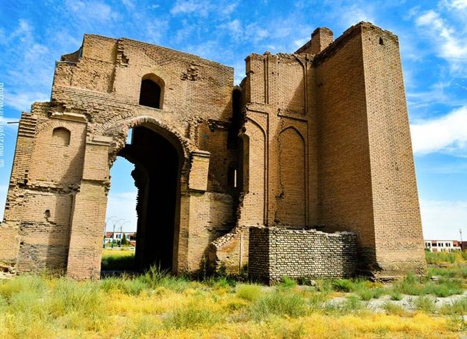
ایوان طرق
در مجاورت پل، بنای باشکوهی به نام ایوان طرق قرار دارد که یادآور شکوه معماری ایرانی در دوران تیموری است. جالب آنکه در بررسی ریشههای واژگانی، شباهت آوایی میان "طرق" و "ترک" نیز قابل تأمل است.
هرچند تزئینات داخلی ایوان تا حد زیادی از میان رفتهاند، اما کتیبهای معرق باقی مانده که ارزش هنری و تاریخی قابل توجهی دارد. این ایوان، اگرچه بهلحاظ تزئینات آرایه های آمودی ساده است، اما از منظر مهندسی سازه، یکی از نمونههای کمنظیر در میان بناهای تیموری محسوب میشود.
_____________________________
The historical Toroq Dam, with the semantic root of "roads", is a natural attraction in the southeast of Mashhad. Between Shahid Hasheminejad International Airport and this dam is the historical Tork Bridge, which was built in an uneven manner.
Torogh Bridge of Kashafrud
On the route of this bridge, there is the metal Toroq Bridge. This metal bridge is located on the Torogh River, in other words, a branch of Kashafrud, which is of particular importance due to its proximity to the pilgrimage sites and the route to Neyshabur.
However, the importance of the Toroq Bridge is not limited to its architectural features. This bridge is located in a historical area with numerous valuable monuments around it; including the Toroq Porch, the historical Toroq Dam, the Imam Reza Pilgrimage Site, and its proximity to Ghadir Forest Park and Shahid Hasheminejad Airport in Mashhad has added to its attractiveness and historical status. This area has become one of the points of interest for tourists, researchers of architectural history, and enthusiasts of Timurid works.
Ivan Toroq : A Magnificent Legacy from the Timurid Era
Ivan Toroq
Near the bridge is a magnificent building called Ivan Toroq, which is a reminder of the splendor of Iranian architecture during the Timurid era. Interestingly, when examining the roots of words, the phonetic similarity between "Toroq" and "turk" is also worth considering.