Kashafrud river - رودخانه کشف رود
اینجا درباره رودخانه کشفرود ایران مینویسمKashafrud river - رودخانه کشف رود
اینجا درباره رودخانه کشفرود ایران مینویسمدرباره من
 از اونهام که می گم آدم بایست حرف خودشو بزنه، اما یاد گرفتم که هر حرفی رو تو جاش بزنم، اینجا، هرچی می خوام رو می گم
ادامه...
از اونهام که می گم آدم بایست حرف خودشو بزنه، اما یاد گرفتم که هر حرفی رو تو جاش بزنم، اینجا، هرچی می خوام رو می گم
ادامه...
سفر یکروزه به کلات
نیمه اردیبهشت 1404 هست. کاخ خورشید کلات رو مشهدی ها حداقل یک بار در عمر خود رفته اند. اینبار قصد دارم مسیر شهر توس به کلات را براتون بگم.
شهر توس پر هست از آثار باستانی و موزه. به جز آن، آرامگاه حکیم ادب و حماسه، ابولقاسم فردوسی رو هم دربرگرفته. بعد از این حکیم گرانقدر ستاره های ادب فارسی معاصری چون مهدی اخوان ثالث و محمدرضا شجریان نیز در آرامگاه فردوسی دفن هستند. آرامگاه فرودسی رو ایرانی ها حداقل یکبار در عمر خود رفته اند.
برای اتراق مردمی که به دیدن آرامگاه فردوسی می آیند، حدفاصل پل فردوسی و هارونیه تا آرامگاه یک پارک کالیگرافی گذاشته اند که در آرامش هم بتوان از مناظر و مجسمه های خان های نبرد رستم در شاهنامه عکس گرفت و هم بتوان لحظاتی خوش را داشت.
بقعه در تصویر بالا و مجسمه ها در تصویر پایین:
_cj0i.jpg)
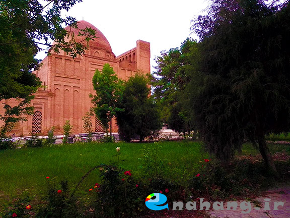
معماری بقعه هارونیه هم جذابیت های خودش را داره:
_rur7.jpg)
در کنار بقعه مسجدی بوده که بقایای آن هست:
_c2no.jpg)
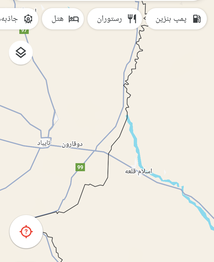
برای رفتن از محل آرامگاه فردوسی شهر توس، این طرف یال های رشته کوه هزار مسجد قرار گرفته به آن طرف یال های کوه ها که کلات قرار داره. قبل از رسیدن به چهاربرج از پل فردوسی که رودبار دروازه شهر باستانی توس هست رد میشویم تا به روستای لقمانی، محل اتصال دو رود رضوان و کشفرود برسیم:
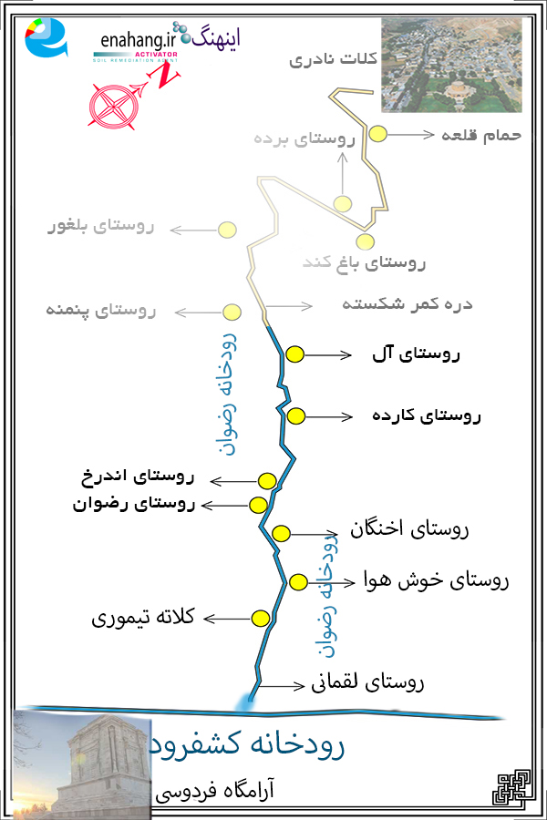
برخی به رودخانه رضوان، رودخانه کارده نیز می گویند و این به دلیل سدی است که بر سر آن با نام کارده بسته اند.
جاده رضوان به کلات چندکیلومتری به شهر توس مانده شروع میشود, این جاده کلات هیچ شباهتی به یک جاده ترانزیت نداشته و بیشتر یک جاده فراموش شده و مخروبه است، هرچند خودروهای زیادی به دلیل آرامستان رضوان که تجمیع آرامستان های روستاهای اطرافه، از آن عبور می کنند. به دلیل هم مسیر بودن این جاده با رودخانه رضوان در طول مسیر گویی باید از میان چند "جویِ خالی از آب" رانندگی کنی و فرمان خودرو به جای اینکه دست راننده باشد در دستانِ پیر جاده قدیمی است, طوری که دیدن مناظر بسیار زیبایِ مسیر جاده رضوان به کلات ( آنهم درفصل بهار ) را لااقل برای راننده مشکل می کند , جاده ای که در کناره اش جایی برای توقف , نه که بگویم اصلاً ندارد، کم دارد.
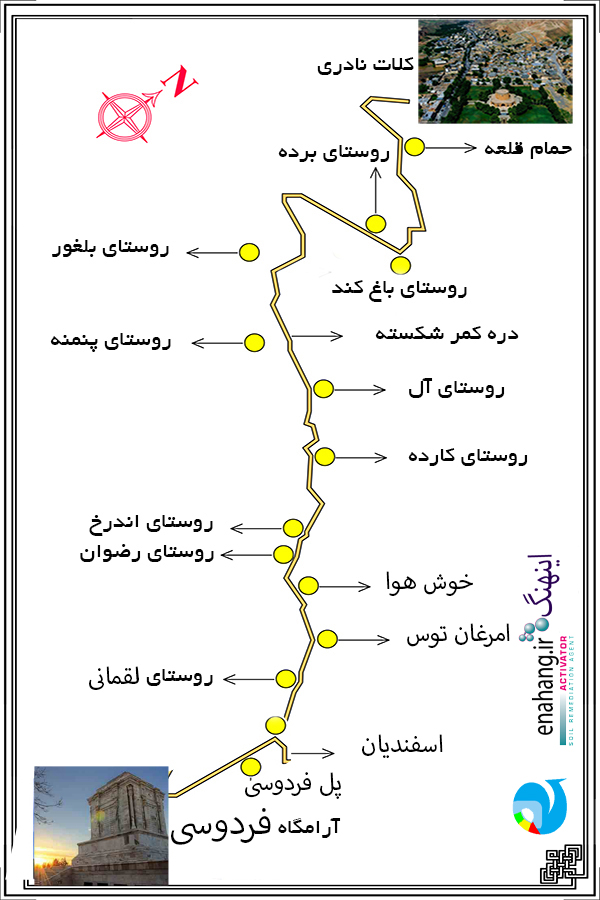
بخشی از رشته کوه هزارمسجد در شهرستان کلات واقع شده است , اصلا همین جاده کلات از کوههای هزار مسجد میگذرد و کوه آل که سرچشمه سد کارده بر روی رودخانه رضوان است در مسیر آن قرار دارد.
با ادامه رشد شهرهایی مثل کلانشهر مشهد، بر میزان زمین های رطوبت ناپذیر افزوده شده. در نتیجه منابع آب زیرزمینی محدودتر شده اند. رسوخ مواد شیمیایی یا آبهای آلوده به آبهای جاری منطقه سبب آلودگی رودخانه ها و نیز نابودی آبزیان میشود. این خشکی و کم آبی زندگی ساکنین مناطق اطراف رودخانه های رضوان و کشفرود را تحت تاثیر قرار داده است. از میزان آبهای زیرزمینی کاسته شده و تبخیر آب از سطح زمین افزایش یافته است.
به دنبال کاهش دسترسی به منابع آبی زیرزمینی، باید بر عمق چاه های آب افزود و یا حداقل به خارج از محدوده شهرها روی آورد تا بتوان نیازهای شهرنشینان را برآورده ساخت. پیشرفت های جدید اصول اساسی تامین آب را تغییر نداده اند. اخیرا موارد بسیاری از آلودگی منابع آبی زیرزمینی و سطحی کشفرود گزارش شده است که شمار بزرگی از آن با روند شهرسازی و شهرنشینی در رابطه اند. مهم ترین این موارد عبارتند از:
حفر چاه به منظور انباشتن مواد آلوده ساز و زباله ها، رها کردن مواد یاد شده در خیابانها، مناطق صنعتی، راه های آهن و فرودگاه ها، نشت آبهای آلوده از لوله ها و مخازن فاضلاب، بی توجهی به چاه های آب، استفاده بی رویه از مواد شیمیایی ویژه امور کشاورزی، وجود حوضه های آب آلوده بدون سرپوش، و رسوخ آبهای شور به منابع آب زیرزمینی.
تامین آب از لایه های ژرف و ژرفتر نیز خود سبب فرونشستن زمین میگردد. کلانشهر مشهد و گسترش آن به شهر توس چنین مشکلاتی را دوچندان کرده است. در مناطقی از دشت مشهد که شامل شهرتوس نیز میشود سالانه بیست سانت فرونشست داریم که کسی متوجه آن نیست. اگر این روند ادامه بیابد تمامی یک ساختمان برج مرکز شهر مشهد در سطحی پایین تر از دریا قرار میگیرند، و دلیل این امر چیزی به جز تهی شدن منابع زیرزمینی از آب نیست.
_______________
One-day trip to Kalat
It is mid-May 2025. The Sun Palace of Kalat has been visited by Mashhadites at least once in their lives. This time I intend to tell you the route from Toos to Kalat.
Toos is full of ancient monuments and museums. In addition, it contains the tomb of the sage of literature and epic, Abolghasem Ferdowsi. After this great sage, stars of contemporary Persian literature such as Mehdi Akhavan Thaleth and Mohammad Reza Shajarian are also buried in Ferdowsi's tomb. Iranians have visited Ferdowsi's tomb at least once in their lives.
For the comfort of people who come to visit Ferdowsi's tomb, a calligraphy park has been set up between the Ferdowsi Bridge and Harounieh to the tomb, where you can take pictures of the scenery and statues of the khans of the Battle of Rostam in Shahnameh and have fun.
The tomb in the picture above and the statues in the picture below:
The architecture of the Harunieh tomb also has its own charms:
Next to the tomb was a mosque with its remains:
To go from the site of Ferdowsi's tomb in Toos, on this side are the ridges of the Hezar Masjid mountain range to the other side of the ridges of the mountains where Kalat is located. Before reaching Chahar Borj, we pass by Ferdowsi Bridge, which is the gateway to the ancient city of Toos, to reach the village of Logmani, the junction of the two rivers Rezvan and Kashfrud:
Some also call the Rezvan River the Kardeh River, and this is because of the dam that has been built across it with the name Kardeh.
The Rezvan-Kalat road begins a few kilometers from Toos. This Kalat road has nothing to do with a transit road and is mostly a forgotten and dilapidated road, although many cars pass through it because of the Rezvan Mausoleum, which is a collection of mausoleums from surrounding villages. Due to the fact that this road runs parallel to the Rezvan River, it seems as if you have to drive through several "waterless streams" along the way, and the steering wheel of the car is in the hands of the old road, instead of the driver's hands, so that it is difficult for the driver to see the very beautiful scenery of the Rezvan-Kalat road (especially in spring), a road that has no place to stop, not to say that it does not have any, it is lacking.
Part of the Hezar Masjid mountain range is located in Kalat city, and the Kalat road itself passes through the Hezar Masjid mountains, and Mount Al, which is the source of the Kardeh Dam on the Rezvan River, is located on its route.
With the continued growth of cities such as the Mashhad metropolis, the amount of impermeable land has increased. As a result, groundwater resources have become more limited. The infiltration of chemicals or contaminated water into the flowing waters of the region causes pollution of the rivers and also the destruction of aquatic life. This drought and water shortage have affected the lives of residents of the areas around the Rezvan and Kashfrud rivers. The amount of groundwater has decreased and evaporation from the ground surface has increased.
As access to groundwater resources has decreased, the depth of water wells must be increased or at least moved outside the city limits to meet the needs of urban dwellers. New developments have not changed the basic principles of water supply. Recently, many cases of contamination of groundwater and surface water resources have been reported, a large number of which are related to the process of urban development and urbanization. The most important of these cases are:
Drilling wells to accumulate pollutants and waste, dumping the aforementioned materials on streets, industrial areas, railways and airports, leaking contaminated water from pipes and sewage tanks, neglect of water wells, excessive use of chemicals for agricultural purposes, the existence of contaminated water basins without covers, and the infiltration of salt water into groundwater resources.
Water supply from deeper and deeper layers also causes land subsidence. The metropolis of Mashhad and its expansion to Toos city have compounded such problems. In areas of the Mashhad plain, which includes Toos city, we have a subsidence of twenty centimeters per year, which no one notices. If this trend continues, an entire tower building in the center of Mashhad city will be below sea level, and the reason for this is nothing other than the depletion of underground water resources.
حوضه آبریز کشفرود و اهمیت آن پس از قره قوم
پس از بررسی پوشش گیاهی کشفرود میرویم که آن را در میان حوضه های آبریز پایه مشخص کنیم.
معرفی حوضه های آبریز ایران:
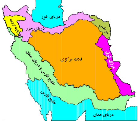
بر اساس تقسیم بندی هیدرولوژیکی دفتر مطالعات پایه منابع آب شرکت مدیریت منابع آب کشور ایران ، منابع آبی کشور به شش حوضه آبریز اصلی و سی حوضه فرعی به شرح ذیل تقسیم می شود .
1- حوضه آبریز اصلی دریای خزر : که شامل 7 حوضه آبریز فرعی به شرح ذیل می باشد :
1 – 1) حوضه آبریز رودخانه های تالش – مرداب انزلی
1- 2)حوضه آبریز رودخانه ارس
1- 3)حوضه آبریز رودخانه سفید رود
1- 4)حوضه آبریز رودخانه های بین سفید رود و هراز
1-5)حوضه آبریز رودخانه های بین هراز و قره سو
1-6)حوضه آبریز رودخانه های بین قره سو و گرگانرود
1-7)حوضه آبریز رودخانه اترک
2- حوضه های اصلی خلیج فارس – دریای عمان : که شامل 9 حوضه آبریز فرعی به شرح ذیل می باشد :
2-1) حوضه آبریز رودخانه های مرزی غرب
2-2)حوضه آبریز رودخانه کرخه
3-2)حوضه آبریز رودخانه کارون بزرگ
4-2)حوضه آبریز رودخانه جراحی – زهره
5-2)حوضه آبریز رودخانه حله
6-2)حوضه آبریز رودخانه مند
7-2)حوضه آبریز رودخانه های کل – مهران و جزایر خلیج فارس
8-2)حوضه آبریز رودخانه های بین بندر عباس - سدیج
9-2)حوضه آبریز رودخانه های بلوچستان جنوبی
3- حوضه آبریز اصلی دریاچه ارومیه : شامل یک حوضه آبریز فرعی با همین نام می باشد.
4- حوضه آبریز فلات مرکزی : که شامل 9 حوضه آبریز غرعی به شرح ذیل می باشد .
4-1) حوضه آبریز دریاچه نمک
4-2)حوضه آبریز گاوخونی
4-3)حوضه آبریز دریاچه های طشک- بختگان و مهار لو
4-4)حوضه آبریز کویر ابرکوه - سیرجان
4-5)حوضه آبریز جازموریان
4-6)حوضه آبریز کویر لوت
4-7)حوضه آبریز کویر مرکزی
4-8)حوضه آبریز اردستان ، ریگ زرین و سیاه کوه
4-9)حوضه آبریز کویر های در انجیر و ساغند
5- حوضه آبریز اصلی مرزی شرق : که شامل 3 حوضه آبریز فرعی به شرح ذیل می باشد
5-1) حوضه آبریز دق پترگان – نمکزار خواف
5-2) حوضه آبریز هامون مشکیل
5-3) حوزه آبریز هیرمند
6- حوضه آبریز اصلی قره قوم (سرخس) : شامل یک حوضه آبریز فرعی با همین نام می باشد( شامل رودخانه های کشف رود ، هریرود یا قره قوم می باشد ) .
کشفرود رودی تاریخی است که تعدادی از انشعابات آن از کوه های هزار مسجد و انشعاباتی از آن از کوه های بینالود سرچشمه می گیرد. حوضه آبریز این رودخانه از جایی که سرچشمه اترک است، جایی در نزدیکی استان گلستان آغاز میشود.
حوضه آبریز این رودخانه با رودهای گرگانرود و قره سو در استان های گلستان و مازندران، از پوشش گیاهی هیرکانی برخوردار است.
رودخانه 294 کیلومتری کشفرود از غرب به شرق جریان دارد و از پل چشمه گیلاس، پل فردوسی و پل شاهی و پل خاتون ادامه مسیر میدهد تا به رودخانه هریرود و از آنجا به رود تجن بپیوندد. این رودخانه مانند هریرود در پایان مسیرش در کشور همسایه زهکشی میشود. منتها مسیر آن برعکس هریرود است. هریرود سرچشمه کوه های هندوکش و از شرق به غرب دارد، ولی کشفرود سرچشمه کوه های هزارمسجد و بینالود و از غرب به شرق دارد. هریرود کشور افغانستان را سیراب میکند، ولی کشفرود مانده است تا مدیریت شهری آن را از خشکرود خارج کند.
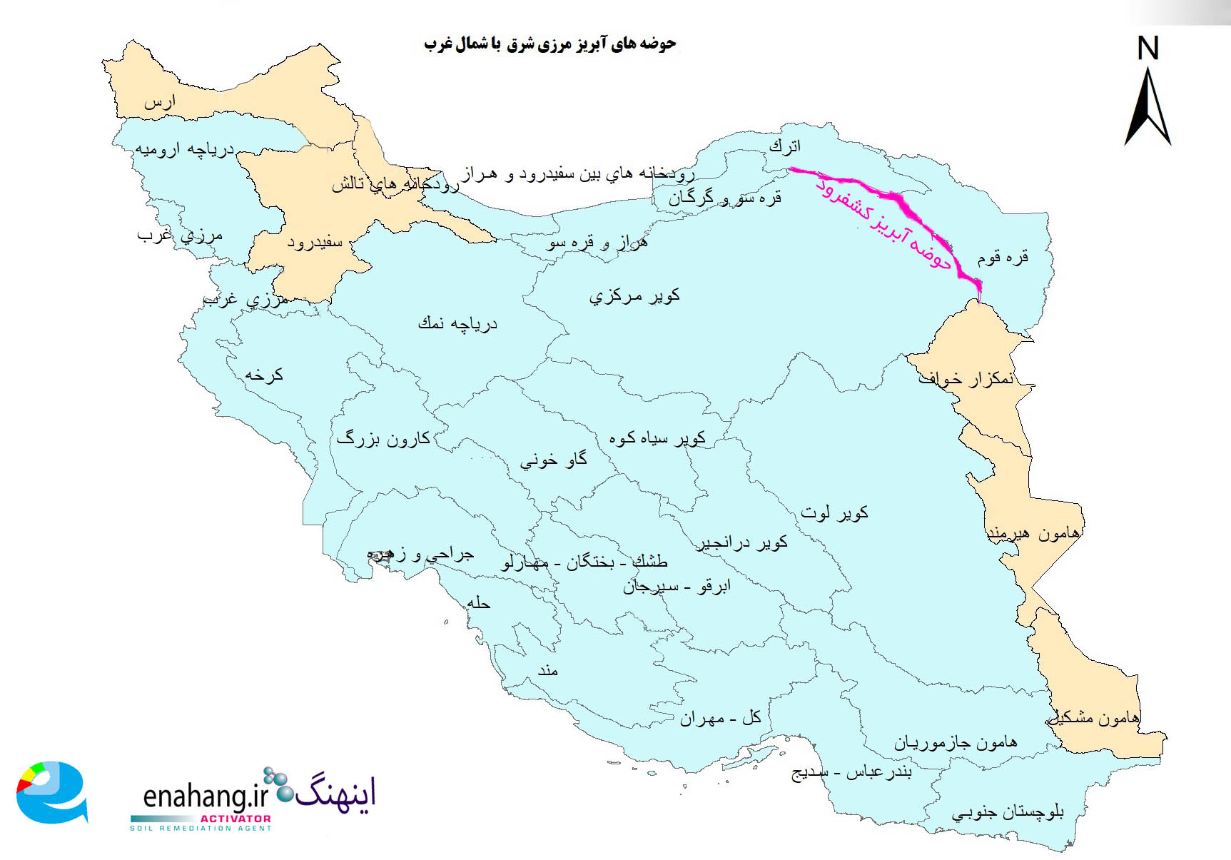
حوضه آبریز کشفرود زمانی اهمیت پیدا میکند که بدانیم در صد سال اخیر رودهایی مثل آمودریا که زمانی از تاجیکستان و ترکمنستان میگذشتند تا از خاک ایران به دریای خزر وارد شوند، با یکی از بزرگترین کانال های دنیا در زمان شوروی سابق تغییر مسیر داده و به دریاچه آرال میریخته است. آمودریا حوضه آبریز قره قوم و یا سرخس را تعریف میکرده است. مسیر این رودخانه اگر هم وجود داشته باشد، به پر آبی سابق نخواهد بود، و حتی دریاچه آرال هم سیرآب نمیکند. کانال های کشاورزی در مسیر آمودریا آن را نیز دچار تنش کرده است. در این هنگام حوضه آبریز کشفرود اهمیت پیدا میکند که آن را حفظ کنیم:
آب دریا را گر نتوان کشید / هم بقدر تشنگی باید چشید
بسیاری امیدوارند که رودهایی مثل آمودریا و هریرود دوباره از مسیر تایباد وارد ایران شوند، ولی تصاویر هوایی چیز دیگری را نشان میدهد:
من برای پیدا کردن سرچشمه هریرود از کلمه جمنازیوم هریرود استفاده میکنم. مشابه این کلمه که وارداتی از آلمان به هرات است، در فارسی ایرانی کمتر یافت میشود. ضمن اینکه اگر چشمه های ما خشک شوند، به دلیل کاربردهایی مثل کشاورزیست، ولی گویا در هرات و افغانستان آن را طور دیگری میبینند.
_______________________
After examining the vegetation of the Kashafrud River, we will identify it among the basic watersheds.
Introduction to Iran's watersheds:
Based on the hydrological division of the Water Resources Basic Studies Office of the Water Resources Management Company of Iran, the country's water resources are divided into six main watersheds and thirty sub-watersheds as follows.
1- The main basin of the Caspian Sea: which includes 7 sub-basins as follows:
1- 1) The Talesh-Anzali Marsh River Basin
1- 2) The Aras River Basin
1- 3) The Sefid Rud River Basin
1- 4) The River Basin between Sefid Rud and Haraz
1- 5) The River Basin between Haraz and Qara Su
1- 6) The River Basin between Qara Su and Gorgan Rud
1- 7) The Atrak River Basin
2- The main basins of the Persian Gulf - the Sea of Oman: which includes 9 sub-basins as follows:
2- 1) The Western Border River Basin
2- 2) The Karkheh River Basin
3- 2) The Greater Karun River Basin
4- 2) The Jarahi-Zohre River Basin
5- 2) The Hillah River Basin
6-2) Mand River Basin
7-2) Kal-Mehran River Basin and Persian Gulf Islands
8-2) Bandar Abbas-Sedij River Basin
9-2) Southern Balochistan River Basin
3- The main basin of Lake Urmia: It includes a sub-basin of the same name.
4- The Central Plateau Basin: It includes 9 sub-basins as follows.
4-1) Salt Lake Basin
4-2) Gavkhoni Basin
4-3) Tashk-Bakhtegan and Mahar Lu Lakes Basin
4-4) Abarkuh-Sirjan Desert Basin
4-5) Jazmorian Desert Basin
4-6) Lut Desert Basin
4-7) Central Desert Basin
4-8) Ardestan, Rig Zarrin and Siah Kooh Basin
4-9) Dar Anjir and Saghand Desert Basin
5- Main Eastern Border Basin: which includes 3 sub-basins as follows
5-1) Dagh-Petrgan-Namzar Khaf Basin
5-2) Hamun-Meshkil Basin
5-3) Hirmand Basin
6- Main Qara Qom Basin: includes a sub-basin with the same name (including the Kashf-Rood rivers , Harirud or Qara Qom).
The Kashfrud is a historical river that has a number of branches originating from the Hezar Masjid Mountains and some branches originating from the Binalud Mountains. The river's watershed begins near the source of Atrak, near Golestan Province.
The river's watershed, along with the Gorganrood and Qara Su rivers in Golestan and Mazandaran provinces, has Hyrcanian vegetation.
The 294-kilometer Kashfrud River flows from west to east and continues its route through the Cheshme Gilas Bridge, Ferdowsi Bridge, Shahi Bridge, and Khatoon Bridge to join the Harirud River and from there to the Tajan River. Like the Harirud, this river drains into a neighboring country at the end of its route. However, its route is the opposite of the Harirud. The Harirud originates in the Hindu Kush Mountains and runs from east to west, while the Kashfrud originates in the Hezar Masjid and Binalud Mountains and runs from west to east. Harirud irrigates Afghanistan, but Kashfrud is left to take its urban management out of Khoshkrud.
The Kashfrud watershed becomes important when we know that in the last hundred years, rivers like the Amu Darya, which once passed through Tajikistan and Turkmenistan to enter the Caspian Sea through Iranian soil, have changed their course with one of the largest canals in the world during the former Soviet era and flowed into the Aral Sea. The Amu Darya used to define the watershed of Karaganda (Qare Qum) or Sarakhs. If this river existed, its course would not be as watery as it once was, and even the Aral Sea does not irrigate. Agricultural canals along the Amu Darya have also strained it. At this time, the Kashfarud watershed becomes important to preserve:
If you can't draw the water of the sea / you must taste it as much as you are thirsty
Many hope that rivers like the Amu Darya and Harirud will enter Iran again through the Taybad route, but aerial images show something else:
I use the word Harirud Gymnasium to find the source of the Harirud. A similar word, which is imported from Germany to Herat, is rarely found in Iranian Persian. In addition, if our springs dry up, it is due to uses such as agriculture, but it seems that in Herat and Afghanistan they see it differently.
آزادسازی سواحل شهید جمهور رئیسی
_1zhb.jpg)
از جمله اقدامات مهم شهید رئیسی بعد از رسیدن به ریاست جمهوری، رسیدگی کامل به تمام رودها و دریاهای کشور بود. تلاش ایشان مثال زدنی و بی بدیل بود. شهید رئیسی هنگام افتتاح سد در مرز ایران و آذربایجان شهید میشود. او پس از رسیدن به ریاست جمهوری، با اینکه وعده نداده بود، شروع به تبلیغ درباره زیبایی های ممکن و گردشگری رودخانه ها کرد. این تبلیغ برای تمام رودها بود: رود ارس، رود اترک، کشفرود، زاینده رود، و کارون به عنوان 5 رود مهم ایران در اولویت شهید رئیسی قرار گرفتند. کافیست یک جستجو بزنید "کشفرود 1401"، "ارس 1401"، "اترک 1401" و غیره. با یک جستجوی ساده میبینید که اگر دولتی بخواهد کاری انجام دهد همان دستگاه که در کنار رودخانه "کال" و "فاضلاب" می نشاند، رود را با زیبایی هایش منحصر به فرد میبیند!
اردک رودخانه به پنجابی:
Among the important measures taken by Shahid Raisi after becoming president was to fully address all the rivers and seas of the country. His efforts were exemplary and unparalleled. Shahid Raisi was martyred while inaugurating the dam on the border of Iran and Azerbaijan. After becoming president, although he had not made any promises, he started to advertise about the possible beauties of rivers. This advertisement was for all rivers: Aras River, Atrak River, Kashfarud, Zayandeh Rud, and Karun were prioritized by Shahid Raisi as the 5 most important rivers of Iran. Just do a search for "Kashfarud 1401", "Aras 1401", "Atrak 1401", etc. With a simple search, you will see that if a government wants to do something, the same apparatus that installs "Kal" and "Fazalab" rivers will see the river as unique with its beauties!
River Duck in Punjabi:
ਵਿਸ਼ਵ ਬੱਤਖ ਦਿਵਸ
ਮਿੱਟੀ ਦੀ ਪਹਾੜੀ 'ਤੇ ਇੱਕ ਸੁੰਦਰ ਬਗਲੇ ਨੂੰ ਦੇਖਣਾ, ਗਿੱਲੀਆਂ ਥਾਵਾਂ 'ਤੇ ਪ੍ਰਵਾਸੀ ਬੱਤਖਾਂ, ਅਤੇ ਪੀਲੇ ਪਤਝੜ ਦੇ ਖੇਤਾਂ ਵਿੱਚ ਇੱਕ ਖੇਡਣ ਵਾਲੀ ਲੂੰਬੜੀ; ਇਹ ਕਸ਼ਫ਼ ਨਦੀ ਦੇ ਬੇਸਿਨ ਦੇ ਗਿੱਲੇ ਇਲਾਕਿਆਂ ਦੇ ਆਪਣੇ ਕਈ ਘੰਟਿਆਂ ਦੇ ਦੌਰੇ ਦੌਰਾਨ ਸਾਨੂੰ ਜੋ ਦੇਖਣ ਦਾ ਆਨੰਦ ਆਇਆ, ਉਸਦਾ ਸਾਰ ਹੈ। ਹਰ ਸਾਲ, ਖੁਰਾਸਾਨ ਰਜ਼ਾਵੀ ਵਿੱਚ ਪ੍ਰਵਾਸੀ ਜਲਜੀ, ਨੇੜੇ-ਜਲਜੀ ਅਤੇ ਜ਼ਮੀਨੀ ਪੰਛੀਆਂ ਦੀ ਗਣਨਾ 1 ਜਨਵਰੀ ਤੋਂ 20 ਫਰਵਰੀ ਤੱਕ ਜਾਰੀ ਰਹਿੰਦੀ ਹੈ, ਅਤੇ ਵਾਤਾਵਰਣ ਸੰਗਠਨ ਦੇ ਅੰਕੜਿਆਂ ਅਨੁਸਾਰ, ਪਿਛਲੇ ਸਾਲ, ਖੁਰਾਸਾਨ ਰਜ਼ਾਵੀ ਵਿੱਚ ਇਨ੍ਹਾਂ ਪੰਛੀਆਂ ਦੀਆਂ 40 ਕਿਸਮਾਂ ਦੀ ਪਛਾਣ ਕੀਤੀ ਗਈ ਸੀ, ਜਿਨ੍ਹਾਂ ਦੀ ਕੁੱਲ ਗਿਣਤੀ 15,700 ਸੀ। ਉਨ੍ਹਾਂ ਵਿੱਚੋਂ ਸਭ ਤੋਂ ਵੱਡੀ ਆਬਾਦੀ ਹਰੇ ਸਿਰ ਵਾਲੀ ਬੱਤਖ ਦੀ ਸੀ।
ਇੱਕ ਬਾਜ਼ ਸ਼ਰੀਤੀ ਪਾਵਰ ਪਲਾਂਟ ਦੇ ਉੱਪਰ ਉੱਡਦਾ ਹੈ, ਇਸਦਾ ਪੂਰਾ ਨਾਮ ਸਟੈੱਪ ਈਗਲ ਹੈ। ਇੱਕ ਅਜਿਹੀ ਪ੍ਰਜਾਤੀ ਜੋ, ਪੰਛੀ ਨਿਗਰਾਨਾਂ ਦੇ ਅਨੁਸਾਰ, ਅਲੋਪ ਹੋਣ ਦੇ ਖ਼ਤਰੇ ਵਿੱਚ ਹੈ। ਇਹ ਦੇਖਣਾ ਬਹੁਤ ਮਜ਼ੇਦਾਰ ਹੈ। ਖਾਸ ਕਰਕੇ ਕਿਉਂਕਿ ਉਹ ਅਸਮਾਨ ਵਿੱਚ ਇੱਕ ਲਾਲ-ਚਿੱਕ ਵਾਲੇ ਮੈਗਪਾਈ ਨਾਲ ਲੜ ਰਿਹਾ ਹੈ, ਅਤੇ ਅਜਿਹਾ ਲੱਗਦਾ ਹੈ ਕਿ ਕਾਂ ਉਸਨੂੰ ਇਸ ਖੇਤਰ ਤੋਂ ਦੂਰ ਲਿਜਾਣ ਲਈ ਪਰੇਸ਼ਾਨ ਕਰ ਰਿਹਾ ਹੈ, ਜੋ ਕਿ ਕਿਸੇ ਤਰ੍ਹਾਂ ਉਸਦੇ ਖੇਤਰ ਵਿੱਚ ਹੈ। ਪਰ ਇਸ ਬਾਜ਼ ਦੀ ਯਾਤਰਾ ਦੀ ਸ਼ੁਰੂਆਤ ਵਿੱਚ ਮੌਜੂਦਗੀ ਦਾ ਕਾਰਨ ਮਾਡਲ ਫਾਰਮ ਅਤੇ ਇਸਦੇ ਬੁੱਚੜਖਾਨੇ, ਅਤੇ ਸ਼ਿਕਾਰੀ ਪੰਛੀਆਂ ਦੁਆਰਾ ਬੁੱਚੜਖਾਨੇ ਦੀਆਂ ਲਾਸ਼ਾਂ ਦੇ ਅਵਸ਼ੇਸ਼ਾਂ ਦੀ ਵਰਤੋਂ ਕਰਨ ਤੱਕ ਵਾਪਸ ਜਾਂਦਾ ਹੈ।
ਥੋੜ੍ਹਾ ਅੱਗੇ ਜਾ ਕੇ, ਸਾਨੂੰ ਇੱਕ ਹੋਰ ਸ਼ਿਕਾਰੀ ਪੰਛੀ ਦਿਖਾਈ ਦਿੰਦਾ ਹੈ। ਇੱਕ ਅਜਿਹਾ ਪੰਛੀ ਜਿਸਨੂੰ ਜ਼ਿਆਦਾਤਰ ਸ਼ਹਿਰ ਵਾਸੀ ਸਾਰਾ ਸਾਲ ਅਸਮਾਨ ਵੱਲ ਉਂਗਲੀ ਨਾਲ ਇਸ਼ਾਰਾ ਕਰਦੇ ਹਨ, ਇਹ ਸੋਚ ਕੇ ਕਿ ਉਹ ਇੱਕ ਬਾਜ਼ ਹੈ। ਪਰ ਨਕੀਬੀ ਕਹਿੰਦਾ ਹੈ ਕਿ ਉਸਦਾ ਨਾਮ ਸਰਗੇਪੇ ਪਾਲੈਂਡ ਹੈ ਅਤੇ ਉਹ ਸਾਡੇ ਸੂਬੇ ਦਾ ਰਹਿਣ ਵਾਲਾ ਹੈ। ਬਾਜ਼ ਬਾਜ਼ ਨਾਲੋਂ ਛੋਟਾ ਹੁੰਦਾ ਹੈ ਅਤੇ ਤਿੰਨ ਰੰਗਾਂ ਵਿੱਚ ਆਉਂਦਾ ਹੈ: ਗੂੜ੍ਹਾ, ਹਲਕਾ ਅਤੇ ਭੌਰ।
ਬੱਤਖਾਂ ਦੇ ਪ੍ਰਵਾਸ ਖੇਤਰ ਉਹਨਾਂ ਖੇਤਰਾਂ ਨੂੰ ਦਰਸਾਉਂਦੇ ਹਨ ਜਿੱਥੋਂ ਬੱਤਖਾਂ ਪ੍ਰਵਾਸ ਕਰਨ, ਖੁਆਉਣ, ਆਰਾਮ ਕਰਨ ਜਾਂ ਸਾਥੀ ਕਰਨ ਲਈ ਲੰਘਦੀਆਂ ਹਨ। ਇਹਨਾਂ ਖੇਤਰਾਂ ਵਿੱਚ ਨਦੀਆਂ, ਝੀਲਾਂ, ਗਿੱਲੀਆਂ ਜ਼ਮੀਨਾਂ, ਦਲਦਲਾਂ, ਜਾਂ ਸਮੁੰਦਰੀ ਕਿਨਾਰੇ ਸ਼ਾਮਲ ਹੋ ਸਕਦੇ ਹਨ ਜੋ ਬੱਤਖਾਂ ਦੇ ਰਹਿਣ ਲਈ ਢੁਕਵੀਆਂ ਸਥਿਤੀਆਂ ਪ੍ਰਦਾਨ ਕਰਦੇ ਹਨ। ਬੱਤਖਾਂ ਆਮ ਤੌਰ 'ਤੇ ਖਾਸ ਪ੍ਰਵਾਸ ਰੂਟਾਂ ਦੀ ਪਾਲਣਾ ਕਰਦੀਆਂ ਹਨ, ਅਤੇ ਇਹ ਰੂਟ ਕਈ ਕਾਰਨਾਂ ਕਰਕੇ ਉਨ੍ਹਾਂ ਲਈ ਆਕਰਸ਼ਕ ਹੋ ਸਕਦੇ ਹਨ, ਜਿਸ ਵਿੱਚ ਮੌਸਮ ਦੀਆਂ ਸਥਿਤੀਆਂ, ਭੋਜਨ ਸਰੋਤ ਅਤੇ ਸੁਰੱਖਿਆ ਸ਼ਾਮਲ ਹਨ। ਇਹਨਾਂ ਰਸਤਿਆਂ 'ਤੇ, ਬੱਤਖਾਂ ਅਕਸਰ ਵੱਡੇ ਸਮੂਹਾਂ ਜਾਂ ਛੋਟੇ ਝੁੰਡਾਂ ਵਿੱਚ ਵੰਡੀਆਂ ਜਾਂਦੀਆਂ ਹਨ ਅਤੇ ਸਾਲ ਦੇ ਵੱਖ-ਵੱਖ ਸਮਿਆਂ 'ਤੇ ਪ੍ਰਜਨਨ ਜਾਂ ਭੋਜਨ ਲਈ ਵਧੇਰੇ ਢੁਕਵੇਂ ਖੇਤਰਾਂ ਵਿੱਚ ਪ੍ਰਵਾਸ ਕਰ ਸਕਦੀਆਂ ਹਨ।
ਇਹ ਥਾਵਾਂ ਬੱਤਖਾਂ ਦੇ ਕੁਦਰਤੀ ਨਿਵਾਸ ਸਥਾਨਾਂ ਦੀ ਜਾਂਚ ਅਤੇ ਅਧਿਐਨ ਕਰਨ ਲਈ ਵੀ ਮਹੱਤਵਪੂਰਨ ਹਨ, ਕਿਉਂਕਿ ਇਹ ਇਨ੍ਹਾਂ ਪੰਛੀਆਂ ਅਤੇ ਉਨ੍ਹਾਂ ਦੇ ਕੁਦਰਤੀ ਵਾਤਾਵਰਣ ਦੀ ਰੱਖਿਆ ਵਿੱਚ ਮਦਦ ਕਰ ਸਕਦੀਆਂ ਹਨ। ਬੱਤਖਾਂ ਕਿੱਥੋਂ ਲੰਘਦੀਆਂ ਹਨ, ਇਹ ਜਾਣਨਾ ਖੋਜਕਰਤਾਵਾਂ ਅਤੇ ਸੰਭਾਲਵਾਦੀਆਂ ਨੂੰ ਇਨ੍ਹਾਂ ਨਿਵਾਸ ਸਥਾਨਾਂ ਦੀ ਬਿਹਤਰ ਦੇਖਭਾਲ ਕਰਨ ਵਿੱਚ ਮਦਦ ਕਰਦਾ ਹੈ ਅਤੇ, ਜੇ ਜ਼ਰੂਰੀ ਹੋਵੇ, ਤਾਂ ਬੱਤਖਾਂ ਨੂੰ ਵੱਖ-ਵੱਖ ਖ਼ਤਰਿਆਂ ਤੋਂ ਬਚਾਉਣ ਲਈ ਕਦਮ ਚੁੱਕਣ ਵਿੱਚ ਮਦਦ ਕਰਦਾ ਹੈ।
ਅੰਤਰਰਾਸ਼ਟਰੀ ਬੱਤਖ ਦਿਵਸ ਇੱਕ ਖਾਸ ਦਿਨ ਹੈ ਜੋ ਵਿਸ਼ਵ ਕੈਲੰਡਰ 'ਤੇ ਇਨ੍ਹਾਂ ਸੁੰਦਰ ਅਤੇ ਅਦਭੁਤ ਪੰਛੀਆਂ ਦੇ ਸਨਮਾਨ ਲਈ ਮਨਾਇਆ ਜਾਂਦਾ ਹੈ। ਇਸ ਦਿਨ ਨੂੰ ਬੱਤਖਾਂ ਅਤੇ ਉਨ੍ਹਾਂ ਦੇ ਕੁਦਰਤੀ ਨਿਵਾਸ ਸਥਾਨਾਂ ਦੀ ਰੱਖਿਆ ਦੇ ਮਹੱਤਵ ਬਾਰੇ ਜਾਗਰੂਕਤਾ ਪੈਦਾ ਕਰਨ ਦੇ ਮੌਕੇ ਵਜੋਂ ਮਾਨਤਾ ਪ੍ਰਾਪਤ ਹੈ। ਬੱਤਖਾਂ, ਜਲ-ਪੰਛੀਆਂ ਦੀ ਇੱਕ ਪ੍ਰਜਾਤੀ ਦੇ ਰੂਪ ਵਿੱਚ, ਜਲ-ਪੰਛੀਆਂ ਅਤੇ ਧਰਤੀ ਦੇ ਵਾਤਾਵਰਣ ਪ੍ਰਣਾਲੀਆਂ ਵਿੱਚ ਇੱਕ ਮਹੱਤਵਪੂਰਨ ਭੂਮਿਕਾ ਨਿਭਾਉਂਦੀਆਂ ਹਨ, ਅਤੇ ਕੀੜਿਆਂ ਦੀ ਆਬਾਦੀ, ਜਲ-ਪੌਦਿਆਂ ਨੂੰ ਕੰਟਰੋਲ ਕਰਨ ਅਤੇ ਕੁਝ ਵਾਤਾਵਰਣ ਪ੍ਰਣਾਲੀਆਂ ਵਿੱਚ ਸੰਤੁਲਨ ਬਣਾਈ ਰੱਖਣ ਵਿੱਚ ਵੀ ਪ੍ਰਭਾਵਸ਼ਾਲੀ ਹੁੰਦੀਆਂ ਹਨ।
ਵਿਸ਼ਵ ਡੱਕ ਦਿਵਸ ਆਮ ਤੌਰ 'ਤੇ ਦੁਨੀਆ ਭਰ ਵਿੱਚ ਵਿਦਿਅਕ ਪ੍ਰੋਗਰਾਮਾਂ, ਪ੍ਰਦਰਸ਼ਨੀਆਂ ਅਤੇ ਸਮਾਗਮਾਂ ਨਾਲ ਮਨਾਇਆ ਜਾਂਦਾ ਹੈ। ਇਹ ਦਿਨ ਕੁਦਰਤ ਪ੍ਰੇਮੀਆਂ, ਵਾਤਾਵਰਣ ਕਾਰਕੁਨਾਂ ਨੂੰ ਇਨ੍ਹਾਂ ਪੰਛੀਆਂ ਨੂੰ ਦਰਪੇਸ਼ ਚੁਣੌਤੀਆਂ, ਜਿਵੇਂ ਕਿ ਪਾਣੀ ਪ੍ਰਦੂਸ਼ਣ, ਨਿਵਾਸ ਸਥਾਨਾਂ ਦਾ ਵਿਨਾਸ਼ ਅਤੇ ਜਲਵਾਯੂ ਪਰਿਵਰਤਨ, ਬਾਰੇ ਹੋਰ ਜਾਣਨ ਦਾ ਮੌਕਾ ਦਿੰਦਾ ਹੈ। ਇਸ ਦਿਨ ਨੂੰ ਬੱਤਖਾਂ ਅਤੇ ਹੋਰ ਜਲ-ਪੰਛੀਆਂ ਦੀ ਸਹਾਇਤਾ ਲਈ ਫੰਡ ਇਕੱਠਾ ਕਰਨ ਜਾਂ ਸੰਭਾਲ ਮੁਹਿੰਮਾਂ ਦਾ ਆਯੋਜਨ ਕਰਨ ਦੇ ਮੌਕੇ ਵਜੋਂ ਵੀ ਵਰਤਿਆ ਜਾ ਸਕਦਾ ਹੈ।
ਬਹੁਤ ਸਾਰੇ ਦੇਸ਼ਾਂ ਵਿੱਚ, ਇਹ ਦਿਨ ਗਿੱਲੀਆਂ ਥਾਵਾਂ, ਝੀਲਾਂ ਅਤੇ ਨਦੀਆਂ ਦੇ ਦੌਰੇ ਨਾਲ ਜੁੜਿਆ ਹੋਇਆ ਹੈ, ਜਿੱਥੇ ਬੱਤਖਾਂ ਕੁਦਰਤੀ ਤੌਰ 'ਤੇ ਮੌਜੂਦ ਹੁੰਦੀਆਂ ਹਨ, ਅਤੇ ਲੋਕ ਇਨ੍ਹਾਂ ਪੰਛੀਆਂ ਦੇ ਜੀਵਨ ਨੂੰ ਨੇੜਿਓਂ ਦੇਖ ਸਕਦੇ ਹਨ ਅਤੇ ਉਨ੍ਹਾਂ ਦੇ ਵਿਵਹਾਰ ਅਤੇ ਜ਼ਰੂਰਤਾਂ ਬਾਰੇ ਜਾਣ ਸਕਦੇ ਹਨ। ਖਾਸ ਕਰਕੇ ਉਨ੍ਹਾਂ ਖੇਤਰਾਂ ਵਿੱਚ ਜਿੱਥੇ ਬੱਤਖਾਂ ਪਰਵਾਸ ਕਰਕੇ ਲੰਘਦੀਆਂ ਹਨ, ਇਹ ਦਿਨ ਜੈਵ ਵਿਭਿੰਨਤਾ ਨੂੰ ਸੁਰੱਖਿਅਤ ਰੱਖਣ ਅਤੇ ਵੱਖ-ਵੱਖ ਵਾਤਾਵਰਣ ਪ੍ਰਣਾਲੀਆਂ ਵਿੱਚ ਇਨ੍ਹਾਂ ਪੰਛੀਆਂ ਦੀ ਮਹੱਤਤਾ ਬਾਰੇ ਜਨਤਕ ਜਾਗਰੂਕਤਾ ਨੂੰ ਮਜ਼ਬੂਤ ਕਰਨ ਨਾਲ ਸਬੰਧਤ ਜਸ਼ਨ ਅਤੇ ਵਿਦਿਅਕ ਵਰਕਸ਼ਾਪਾਂ ਆਯੋਜਿਤ ਕਰਨ ਦਾ ਮੌਕਾ ਹੋ ਸਕਦਾ ਹੈ।
ਅੰਤ ਵਿੱਚ, ਵਿਸ਼ਵ ਬੱਤਖ ਦਿਵਸ ਨਾ ਸਿਰਫ਼ ਜਸ਼ਨ ਅਤੇ ਖੁਸ਼ੀ ਦਾ ਦਿਨ ਹੈ, ਸਗੋਂ ਇਹਨਾਂ ਪ੍ਰਜਾਤੀਆਂ ਨੂੰ ਸੰਭਾਲਣ ਅਤੇ ਆਉਣ ਵਾਲੀਆਂ ਪੀੜ੍ਹੀਆਂ ਲਈ ਵਿਸ਼ਵਵਿਆਪੀ ਵਾਤਾਵਰਣ ਨੂੰ ਸੁਰੱਖਿਅਤ ਰੱਖਣ ਲਈ ਪ੍ਰਤੀਬਿੰਬ ਅਤੇ ਕਾਰਵਾਈ ਦਾ ਸਮਾਂ ਵੀ ਹੈ।
پل فردوسی شاهنامه -رودخانه کشف
پل فردوسی شاهنامه بر روی رودخانه کشفرود و نزدیک دروازه باستانی تابران قرار دارد. این دروازه از دیرباز به سبب مجاورت با کشفرود رودبار خوانده میشود. فردوسی «کشف رود» را در داستان کیخسرو و فرود و لشکرکشی طوس بن نوذر به مرز توران «کاسه رود» مینامد. تمدن تاریخی در گذشته در کنار این رودخانه شکل گرفته بود.
_dk88.jpg)
دیوارهای تاریخی تابران از محل همین پل و در امتداد رودخانه اساطیری کشفرود (کاسه رودخانه) آغاز می شود و امروز بقایای آجری آن را میبینید.
آن بخش از دیوار که همچون دژی مستحکم ساخته شده داستانی روایت گر دارد. از سمت دیوار که بالاتر و به سمت آرامگاه شاعر بزرگ و احیاگر فارسی (حکیم ابوالقاسم فردوسی) برویم هارونیه و سایر بقایای تاریخی را که در کنار رودخانه شکل گرفته بودند می بینیم. آثاری همچون آسیاب آبی روستای گوارشک از آن جمله است.
حکیم ابوالقاسم فردوسی دختری نیکسیرت داشت که پس از درگذشت پدر باقی بود و با اعمال نیکش در تاریخ ماندگار شد.
دختر فردوسی را باید در ردیف بانوان نیکاندیش و خیّری همچون گوهرشاد و پریزاد بانو بدانیم که آثار خیرخواهانهاش، هنوز در گوشه و کنار خطه هنرپرور خراسان باقی است و در این نوشتار، به برخی از آنها اشاره خواهیم کرد
مستنداتی وجود دارد که نشان میدهد، به احتمال زیاد، پایههای اولیه بند راهبردی گلستان که در تأمین آبادانی و کشاورزی شاهنامه، سهم انکارناپذیری دارد، توسط دختر فردوسی و با صرف بخشی از دستمزد سرایش شاهنامه گذاشته شد. این موضوعی است که میتوان در متون قدیمی، تاریخ شفاهی و پژوهشهای دوران اخیر، مانند مقاله مربوط به بندگلستان در «دایرةالمعارف آستانقدس رضوی»، ردپایی از آن یافت.
دیگر یادگاری دختر فردوسی، پلی بود که روی رودخانه کشفرود ساخته یا به قولی مرمت شد که برخی موقعیت آن را، در نزدیکی پلخاتون میدانند. این پل که امروزه اثری از آن در دسترس نیست، کاربرد فراوانی داشته و باعث کوتاهشدن مسیر مسافرانی میشده که از فرارودان، قصد مسافرت به ایران را داشتند.
رودخانه کشفرود جاذبه گردشگریست که در مسیر آرامگاه فردوسی قرار دارد. در مسیر آن پلی قرار دارد به نام پل فردوسی که بزرگ و ساده است.
عکس پل فردوسی کشفرود:
_qmj9.jpg)
آدرس دقیق پل فردوسی:
خراسان رضوی، بلوار شاهنامه، میدان سپهبد، رودخانه کشفرود (کشف رود)
____________
Ferdowsi Shahnameh Bridge is located on the Kashfrud River and near the ancient Tabaran Gate. This gate has long been called Rudbar because of its proximity to Kashfrud. Ferdowsi calls "Kashfrud" "Kasehrud" in the story of Kaykhosro and the landing and expedition of Tus ibn Nozar to the border of Turan. Historical civilization was formed along this river in the past.
The historical walls of Tabaran begin from the site of this bridge and along the mythical river Kashfrud (Kasehrud), and today you can see its brick remains.
That part of the wall, which was built like a fortified fortress, has a narrating story. From the side of the wall, going higher and towards the tomb of the great poet and Persian revivalist (Hakim Abul-Qasim Ferdowsi), we see Haruniyeh and other historical remains that were formed along the river. Works such as the water mill of the village of Gidartak are among them.
Hakim Abul-Qasim Ferdowsi had a virtuous daughter who remained after her father passed away and remained in history with her good deeds.
We should consider Ferdowsi's daughter among the well-meaning and charitable women like Goharshad and Parizad Banu, whose charitable works still remain in every corner of the artistic region of Khorasan, and in this article, we will mention some of them.
There is evidence that shows that, most likely, the initial foundations of the strategic Golestan dam, which has an undeniable contribution to ensuring the prosperity and agriculture of Shahnameh, were laid by Ferdowsi's daughter, spending part of the salary of the composer of Shahnameh. This is an issue that can be traced in ancient texts, oral history, and recent research, such as the article on the Golestan dam in the "Encyclopedia of Astan Quds Razavi".
Another relic of Ferdowsi's daughter was a bridge that was built or, as some say, restored over the Kashf-Rud River, which some believe is located near Pol-e-Khatun. This bridge, of which no trace is available today, was widely used and shortened the route for travelers who wanted to travel to Iran via the river.
The Kashfrud River is a tourist attraction located on the way to Ferdowsi's tomb. On its way is a bridge called Ferdowsi Bridge, which is large and simple.
Photo of Ferdowsi Bridge, Kashfrud:
Exact address of Ferdowsi Bridge:
Khorasan Razavi, Shahnameh Boulevard, Sepahbod Square, Kashfrud River (Kashfrud)
و اینهنگ کشفرود - And Enahang Kashfrud
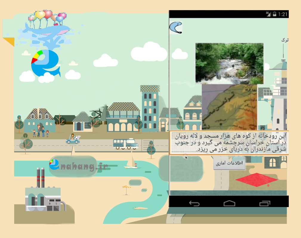
زمانیکه برای رودخانه کارم رو با یک اپلیکیشن آغاز کردم، فکر نمی کردم که از آن استفاده کنند. اپلیکیشن اندروید رودخانه کاربردی بود و حتی در زمینه نمایش رودخانه های مرزی تخصصی عمل کرده بود. از آنجا که بازخوردی نداشتیم، و برعکس هزینه هم باید میکردیم، به عمق کار پی نبردیم تا اکنون که با رودخانه کشفرود کار را دنبال می کنیم. این دنبال کردن به معنی پیگیری یک نیاز از سالها پیش توسط اینهنگ شاپه.
اینهنگ شاپ با رویکرد دریایی:
بارها از دریا و درباره دریا نوشتیم: تهیه نقشههای دریایی به روش مرکاتور، مدیریت آب اینهنگ، طراحی سازه ها و شناورهای دریایی و غیره
ویدئو و اپلیکیشن بازی درست کردیم و باشگاه تشکیل دادیم. در مسابقات شرکت کردیم و اگر شایسته تقدیر بودیم و نکردند، ناامید نشدیم و ادامه دادیم. اگر به سایت اینهنگ شاپ سر بزنید، فقط بخشی از کارها رو خواهید دید:
امروز هستیم و با گذر زمان پی به ارزش کار کردن برای رودخانه، خصوصا کشفرود میبریم.
_________________________
When I started working on an app for the river, I didn’t think they would use it. The Android app for the river was practical and even specialized in displaying border rivers. Since we had no feedback, and on the contrary, we had to pay, we didn’t understand the depth of the work until now that we are following up on the work with the Kashafrud River. This following up means following up on a need from years ago by Enahang Shop.
Enahang Shop with a maritime approach:
We have written many times about and from the sea: preparing sea maps using the Mercator method, managing Enahang water, designing marine structures, etc.
We made videos and game apps and formed a club. We participated in competitions and if we deserved recognition and they didn’t, we didn’t get discouraged and continued. If you visit the Enhang Shop website, you will see only a part of the work:
www.enahang.ir
We are here today and as time goes by, we realize the value of working for the river, especially the Kashfrud.