Kashafrud river - رودخانه کشف رود
اینجا درباره رودخانه کشفرود ایران مینویسمKashafrud river - رودخانه کشف رود
اینجا درباره رودخانه کشفرود ایران مینویسمدرباره من
 از اونهام که می گم آدم بایست حرف خودشو بزنه، اما یاد گرفتم که هر حرفی رو تو جاش بزنم، اینجا، هرچی می خوام رو می گم
ادامه...
از اونهام که می گم آدم بایست حرف خودشو بزنه، اما یاد گرفتم که هر حرفی رو تو جاش بزنم، اینجا، هرچی می خوام رو می گم
ادامه...
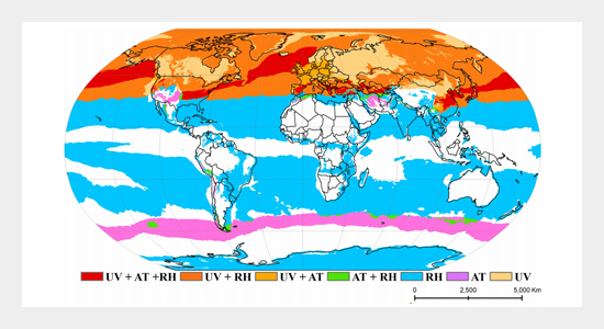
شاخص فرابنفش کشفرود
پارسال در ۱۸ مرداد شاخص فرابنفش ۱۱.۶ بوده، امروز در ۲۲ تیر شاخص فرابنفش از آن هم فراتر رفت: ۱۱.۷ شده
در آن زمان تمام رسانه ها اعلام کردند که به خاطر این شاخص از بیرون رفتن خودداری کنید و بعنوان یک پدیده عجیب این رکورد را ثبت کردند. امروز کسی اشاره ای به این موضوع نکرد. فقط گفتند توده هوای گرم این هفته وارد کشور میشه. اما آنچه که من شاهدش بودم با وجود رطوبت یکسان و بلکه کمی بیشتر نسبت به ۱۸ مرداد سال گذشته باز هم شاخص فرابنفش افزایش یافته بود.
شاخص فرابنفش به میزان سوزانندگی خورشید مربوط میشود و توصیه میشود عدد آن اگر از یازده بالاتر برود بیشتر از نیم ساعت زیر آفتاب قرار نگیریم. هر چند تحمل آن ده دقیقه هم نیست و پلاستیک را میسوزاند.
اروپا جنگل های وسیعی داشته که بر اثر این سوزانندگی خورشید در حال سوختن بوده، اما برای ایران وضع فرق میکند: از آنجا که سطح آبهای سطحی آن هر ساله رو به کاهش است بازسازی شرایط اقلیمی آن دیرتر صورت میگیرد. این زمان بر بودن بازسازی برای حاشیه شهرهایی مثل مشهد که ترافیک بیشتر و آب در دسترس کمتری دارند بیشتر است. برای مشهد آنچه که مسیر عبور کشفرود گفته میشود، جایی است که با در نظر گرفتن آن بعنوان کانال انتقال آب به مردم ساکن آن منطقه بی توجهی شده و ترافیک زیاد و آب در دسترس کمتری نسبت به وسط شهر دارند.
حال سوال این است که چطور با این شرایط شاخص فرابنفش خورشید را در سطح ملی کم کنیم؟
در اینجا من چند گزینه آورده ام:
1. کاهش انتشار آلایندهها و اثر گلخانهای:
کاهش انتشار گازهای گلخانهای:
برای کاهش اثر گلخانهای و تخریب لایه ازن، که هر دو بر میزان اشعه UV رسیده به سطح زمین تأثیر میگذارند، باید اقدامات جدی برای کاهش انتشار گازهای گلخانهای انجام شود.
2. استفاده از انرژیهای تجدیدپذیر:
جایگزینی انرژیهای فسیلی با انرژیهای تجدیدپذیر، مانند انرژی خورشیدی و بادی، میتواند به کاهش انتشار آلایندهها کمک کند.
3. افزایش بهرهوری انرژی:
افزایش بهرهوری انرژی در صنایع و ساختمانها نیز میتواند به کاهش انتشار آلایندهها کمک کند.
اگر عزم ملی جدی در این رابطه داشته باشیم میتوانیم وضعیت موجود را بهتر کنیم.
_____________________
Last year on August 8, the UV index was 11.6, today on July 22, the UV index exceeded that: 11.7
At that time, all the media announced that people should avoid going out because of this index and recorded this record as a strange phenomenon. Today, no one mentioned this issue. They only said that a warm air mass would enter the country this week. But what I witnessed was that despite the same humidity, and even a little more than on August 8 last year, the UV index still increased.
The UV index is related to the degree of sunburn, and it is recommended that if the number is higher than eleven, we should not be in the sun for more than half an hour. Although it cannot be tolerated for even ten minutes and it burns plastic.
Europe has vast forests that are burning due to this sunburn, but the situation is different for Iran: since its surface water level is decreasing every year, its climatic conditions are recovering later. This time-consuming recovery is greater for the outskirts of cities like Mashhad, which have more traffic and less available water. For Mashhad, what is called the Kashkard River crossing is a place that has been neglected by considering it as a water transfer channel for the people living in that area, and there is a lot of traffic and less available water than in the city center.
Now the question is, how do we reduce the sun's ultraviolet index at the national level under these conditions?
Here I have listed a few options:
1. Reducing pollutant emissions and the greenhouse effect:
Reducing greenhouse gas emissions:
To reduce the greenhouse effect and ozone layer depletion, both of which affect the amount of UV radiation reaching the earth's surface, serious measures must be taken to reduce greenhouse gas emissions.
2. Using renewable energy:
Replacing fossil fuels with renewable energy, such as solar and wind energy, can help reduce pollutant emissions.
3. Increasing energy efficiency:
Increasing energy efficiency in industries and buildings can also help reduce pollutant emissions.
If we have a serious national determination in this regard, we can improve the current situation.
کشف رود با هویت تاریخی توس
کشفرود رودخانه ای در شمال کلانشهر مشهد است که اعتبار تاریخی بسیاری دارد. این رودخانه از رشته کوههای هزارمسجد، بینالود و نزدیکی رودخانه اترک در قوچان سرچشمه میگیرد و در طول تاریخ تمدن توس در کنار آن شکل گرفته است.
این رودخانه لاک پشت های ریز بسیاری داشته که نام کشف رود از کشف به معنای لاک پشت گرفته شده و نام کاسه رود از بستر سفالین کاسه طوری این رودخانه است که بارها در شاهنامه به آن اشاره شده است.
این رودخانه که در مسیر خود از چناران، شیروان، گناباد و گلبهار رد میشود پل های تاریخی متعددی دارد که از آن جمله به پل فردوسی در کنار دروازه تاریخی تابران توس میتوان اشاره کرد.
کشفرود در کنار دروازه تاریخی توس و جایی که اکنون به پل فردوسی شهرت دارد، خاطرات متعددی از جنگ را در خود دارد. در شاهنامه فردوسی داستان فرود، بهرام و چند جنگ میان شاهان کیانی همه در شاهنامه و در کنار این رود با نام کاسه رود اتفاق افتاده است. فرود، پسر سیاوش، شخصیتی در شاهنامه با سرشتی پاک است که قربانی نابخردی و خود خواهی و عصبانیت بی مورد طوس سردار سپاه ایران (لشکریان کیخسرو برادر فرود و فرزند فرنگیس و سیاوش ) می شود. در زمان کیخسرو، طوس مسئولیت نگهداری از درفش کاویانی را بر عهده داشت. توس سپهسالار ایران جهت فتح اراضی توران به بهانه کین سیاوش باید از محلی میگذشت که فرود مرزبان آن کشور بود. در نبرد دیگری طوس سپس عازم جنگ با لشکر افراسیاب و تورانیان شد و در طی مسیر به دو راهی مشهور رسید که یکی بیابان بیآب و علف و دیگری خوش آب و هوا بود.
چنین گفت با طوس کامروز جنگ. نه بر آرزو کرد پور پشنگ. گمانم که امشب شبیخون
ز لشکر سواران که بودند گرد
گزین کرد شاه و به رستم سپرد
دگر بهره بگزید ز ایرانیان
که بندند بر تاختن بر میان
به طوس سپهدار داد آن گروه
بفرمود تا رفت بر سوی کوه
تهمتن سپه را به هامون کشید
سپهبد سوی کوه بیرون کشید
بفرمود تا دور بیرون شوند
چپ و راست هر دو به هامون شوند
طلایه مدارند و شمع و چراغ
یکی سوی دشت و یکی سوی راغ
بدان تا اگر سازد افرسیاب
بر او بر شبیخون به هنگام خواب
گر آید سپاه اندر آید ز پس
بماند نباشدش فریادرس
در حماسه های سروده شده در شاهنامه فردوسی آمده است که سپاه ایران در یکی از پادگان های نظامی خود در این منطقه نزدیک کشفرود اردو زده بود. مردم شهر که همه از جمله توران زخم خورده بودند و تعداد خیلی کمی در برج آن پناه گرفته بودند منتظر رسیدن ارتش ایران بودند. این برج در محله چهاربرج نزدیک کلاته برفی بود. ارتش ایران در کنار این رود و چهار برج نبردی سخت با متجاوزین داشته و تلاش میکند آنها را که تا حد خراسان در ایران پیشروی کرده بودند را عقب براند.
پس از آنزمان کل کلاتهبرفی ۶ خانوار داشت که داخل دژ زندگی میکردند. بعد از پیروزی انقلاب دوباره تابلو کلاتهبرفی نصب شد.
امروزه پل فردوسی دو محله کلاته برفی و چهار برج را در کنار خود جای داده است. برای اینکه بدانید کلاته برفی چه جور جایی است، باید سیکشاورز کلاته و سبزدستی آنها را جلو دیدگانتان بیاورید. کلاتهبرفی تا چشم کار میکرد فقط سرسبزی و درخت بود. برفی که در این منطقه می بارید، تا یک ماه بعد از عید نوروز هم آب نمیشد.
________________________
Kashafrud is a river in the north of Mashhad that has a lot of historical value. This river originates from the Hezarmasjid mountain range, Binalud and near the Atrak River in Quchan and was formed along it throughout the history of the Toos civilization.
This river has many small turtles, and the name Kashfrud is derived from Kashf, which means turtle, and the name Kaserud is from the clay bed of the Kaserud, which is mentioned many times in the Shahnameh.
This river, which passes through Chenaran, Shirvan, Gonabad and Golbahar, has many historical bridges, including the Ferdowsi Bridge next to the historical Tabran Toos Gate.
Kashfrud, next to the historical Toos Gate and where it is now known as the Ferdowsi Bridge, contains many memories of war. In Ferdowsi's Shahnameh, the story of Furud, Bahram and several wars between the Kiani kings all took place in the Shahnameh and along this river called Kaserud. Furud, the son of Siavash, is a character in the Shahnameh with a pure nature who falls victim to the foolishness, selfishness, and unnecessary anger of Tous, the commander of the Iranian army (Lashkarian Kaykhosro, brother of Furud and son of Farangis and Siavash). During the time of Kaykhosro, Tous was responsible for guarding the Kaviani flag. Tous, the commander of the Iranian army, had to pass through a place where Furud was the border guard of that country in order to conquer the lands of Turan, under the pretext of Siavash's grudge. In another battle, Tous then set out to fight the army of Afrasiab and the Turanians, and along the way he came to a famous crossroads, one of which was a desert without water and grass, and the other with good weather.
Thus he said to Tous, who was ready to fight. He did not wish for Pur Pshang. I think that tonight, the Shah selected the cavalry from the cavalry that were there and entrusted it to Rostam. He ordered the Iranians to stop attacking. He ordered the Sepahdar to go to the mountain. He ordered the Sepah to go out to the mountain. He ordered them to go out to the left and right. They were both to go to the plain and the other to the valley. They were given gold and candles and lamps. If Afarsiyab came to him while he was sleeping, the army would come in and stay. It is mentioned in the epics written in Ferdowsi's Shahnameh that the Iranian army had camped in one of its military barracks in this area near Kashfrud. The people of the city, all of whom, including Turan, were wounded and a very small number had taken refuge in its tower, were waiting for the Iranian army to arrive. This tower was in the Chahar Borj neighborhood near Kalata Barfi. The Iranian army fought a fierce battle with the invaders along this river and the four towers and is trying to push them back, who had advanced as far as Khorasan in Iran.
After that, the entire Kalateh Barfi had 6 families living inside the fortress. After the victory of the revolution, the Kalateh Barfi sign was installed again.
Today, the Ferdowsi Bridge houses two neighborhoods of Kalateh Barfi and the four towers next to it. To know what kind of place Kalateh Barfi is, you have to imagine thirty Kalateh farmers and their green hands. Kalateh Barfi was all greenery and trees as far as the eye could see. The snow that fell in this area did not melt until a month after Nowruz.
ایران فردوسی
جهان را ببخشید بر چار بهر / وزو نامزد کرد آبادشهر
نخستین خراسان ازو یاد کرد / دل نامداران بدو شاد کرد
دگر بهر زان بد قم و اصفهان / نهاد بزرگان و جای مهان
وزین بهره بود آذرآبادگان / که بخشش نهادند آزادگان
وز ارمینیه تا در اردبیل / بپیمود بینادل و بوم گیل
سیوم پارس و اهواز و مرز خزر / ز خاور ورا بود تا باخت
چهارم عراق آمد و بوم روم / چنین پادشاهی و آباد بوم
سرزمین پهناور ایران با جاهای دیدنی که شامل آثار تاریخی، مناظر طبیعی و فرهنگی متنوع است، به یکی از مقاصد گردشگری جذاب در جهان تبدیل شده است.
در ادامه نام پنج مکان باستانی ایران را برای شما می آوریم:
1- آرامگاه فردوسی
در نزدیکی کشفرود و دیوار باستانی تابران توس، ساختمانی در هفت طبقه که چهار طبقه آن بالای زمین قرار گرفته است. ساختمان مرتفعی است که چهار طرف آن مزین به اشعار شاهنامه فردوسی است. حکیم ابولقاسم فردوسی حماسه سرای بزرگ فارسی که بین حماسه سراهای بزرگ دنیا برترین مقام را دارد. گردشگران زیادی برای دیدار از او به شهر توس مشهد می آیند. برای ایرانیان، او و زبان فارسی در کنار هم قرار گرفته است. فردوسی به عنوان یکی از ستاره های درخشان فرهنگ ایران میدرخشد و همچنان حرف های زیادی برای گفتن دارد.
2-حرم امام رضا
از بناهای تاریخی مشهور ایران، حرم امام رضا علیه السلام است. این حرم که تشکیل شده است از رواق ها و صحن های بزرگ و زیبا مکان زیارتی و مذهبی محسوب میشود که پس از حکومت نادرشاه افشار در مشهد الرضا بنا نهاده شده است. موزه آستان قدس رضوی در نزدیکی کتابخانه بزرگ حرم بنا نهاده شده و شامل آثار باستانی اهدا شده میباشد.
3- تخت جمشید در ایران
داریوش کبیر پایتخت خود را در فارس تاسیس کرد. امپراتوری ایران در آن زمان منطقه پهناوری را شامل میشد که از جلگه های وسیع آسیای مرکزی تا کرانه های نیل و از رود سند هندوستان تا رود دانوب اروپا امتداد داشت.
تخت جمشید اثر معماری با شکوه در آن دوران است که ایرانیان به طبیعت، گل و درخت اهمیت و جایگاه ویژه ای قائل بودند. آثار گل و سرو در جای جای تخت جمشید نمود این جایگاه است. ایرانیان از آن زمان نوروز باستانی را که همزمان با آغاز بهار طبیعت است جشن میگیرند.
4- میدان نقش جهان در ایران
اصفهان در مرکز ایران، توسط شاه عباس اول در دوره صفویه پایتخت ایران شد. شاه عباس صفوی میدان نقش جهان را که در آن مسجدی برای برقراری ارتباط با مردم بنا نهاده شده بود تاسیس کرد. این میدان به شکل یک مربع مستطیل به درازای پانصد متر و پهنای صد و شصت و پنج متر ساخته شده و دو ردیف طاق ضربی آن را احاطه کرده است. در این میدان دسته های عزاداران حسینی حرکت میکردند و یا نمایش های نظامی و چوگان بازی انجام میگرفت. چهار بنای با شکوه مزین به نقاشی های دیواری و کاشی های لعابی درخشان به طور قرینه در اطراف میدان قرار دارند که عبارتند از مسجد امام خمینی، مسجد شیخ لطف الله، قصر عالی قاپو که به قصور دیگری با باغ های وسیع منتهی میگشت.
5- چغا زنبیل در ایران
در شهر باستانی شوش، شهر باستانی چغازنبیل مانند آرامگاه دانیال نبی یکی از آثار باستانی ایران در حاشیه فلاتی که مشرف بر رودخانه آبدیز و جنگل پوشیده از درختان شامل گز قرار دارد. این شهر در درون سه حصار خشتی متحدالمرکز بنا گردیده است. دیوار اولی یک آب انبار بزرگ، سه کاخ، پنج مقبره زیرزمینی و یک معبد است. دیوار دوم هفت معبد و دیوار سوم را سه معبد دیگر در برگرفته اند.
_______________
Iran Ferdowsi
Forgive the world for four blessings / Wozu nominated Abadshahr
The first Khorasan mentioned him / The hearts of the famous people rejoiced in him
Other blessings were bad for Qom and Isfahan / The institution of the great and the place of honor
We were the wealth of Azarabadgan / Who gave the gift to the freedmen
Woz Armenia to Ardabil / He crossed the border between the hearts and the Giles
Sium Pars and Ahvaz and the Caspian border / From the east it was until it was lost
The fourth Iraq came and the Roman world / Such a kingdom and prosperous land
The vast land of Iran with its sights that include historical monuments, diverse natural and cultural landscapes has become one of the attractive tourist destinations in the world.
Below, we bring you the names of five ancient places in Iran:
1- Ferdowsi's tomb
Near Kashfarud and the ancient wall of Tabaran Toos, a seven-story building, four of which are above ground. It is a tall building whose four sides are decorated with poems from Ferdowsi's Shahnameh. Hakim Abul Qasem Ferdowsi is the great Persian epic poet who holds the highest position among the great epic poets of the world. Many tourists come to the city of Toos in Mashhad to visit him. For Iranians, he and the Persian language are placed side by side. Ferdowsi shines as one of the shining stars of Iranian culture and still has a lot to say.
2- Imam Reza Shrine
One of the famous historical monuments in Iran is the Imam Reza Shrine (peace be upon him). This shrine, which consists of large and beautiful porches and courtyards, is considered a pilgrimage and religious place that was built after the reign of Nader Shah Afshar in Mashhad-al-Reza. The Astan Quds Razavi Museum was built near the great library of the shrine and includes donated ancient artifacts.
3- Persepolis in Iran
Darius the Great established his capital in Fars. The Iranian Empire at that time covered a vast area that extended from the vast plains of Central Asia to the banks of the Nile and from the Indus River in India to the Danube River in Europe.
Persepolis is a magnificent architectural work from the era when Iranians attached great importance and importance to nature, flowers, and trees. The works of flowers and cypresses everywhere in Persepolis are a reflection of this place. Since then, Iranians have celebrated the ancient Nowruz, which coincides with the beginning of nature's spring.
4- Naqsh-e Jahan Square in Iran
Isfahan, in central Iran, was made the capital of Iran by Shah Abbas I during the Safavid era. Shah Abbas Safavi established Naqsh-e Jahan Square, where a mosque was built to communicate with the people. This square is built in the shape of a rectangular square, five hundred meters long and one hundred and sixty-five meters wide, and is surrounded by two rows of arched arches. Groups of mourners for Hussein would march in this square, or military displays and polo games would be held. Four magnificent buildings adorned with murals and brilliant glazed tiles are symmetrically arranged around the square: the Imam Khomeini Mosque, the Sheikh Lotfollah Mosque, and the Ali Qapu Palace, which led to another palace with extensive gardens.
5. Chogha Zanbil in Iran
In the ancient city of Susa, the ancient city of Chogha Zanbil, like the tomb of Daniel the Prophet, is one of Iran’s ancient monuments, located on the edge of a plateau overlooking the Abdiz River and a forest covered with trees including Gaz. The city is built within three concentric adobe enclosures. The first wall is a large cistern, three palaces, five underground tombs, and a temple. The second wall is surrounded by seven temples, and the third wall is surrounded by three more temples.
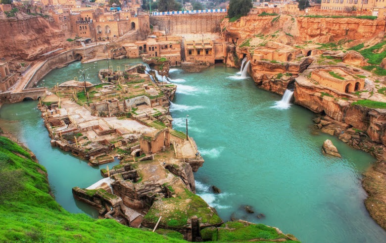
پلهای رودخانه کشفرود؛ شریانهای تاریخی خراسان در مشهد
کشفرود از نام باستانی کشف به معنای لاکپشت گرفته شده است. در شاهنامه فردوسی آن را کاسه رود معرفی کرده است. انتخاب این نام بدلیل ماهیت سفالینه بودن زمین کف رودخانه است.
رودخانه کشفرود، از دامنههای بینالود و هزارمسجد سرچشمه میگیرد و در مسیر شمالی و شمالشرقی مشهد جاری میشود. این رود طی قرنها نقشی کلیدی در شکلگیری روستاها و توسعه تاریخی دشت توس ایفا کرده و پلهای متعددی بر بستر آن ساخته شدهاند که هویت فرهنگی و تمدنی منطقه را بهخوبی بازتاب میدهند.
در این مسیر، پلهای تاریخی و مدرن فراوانی به چشم میخورند که هر یک ارزش مهندسی، اجتماعی و گردشگری خاصی دارند. مهمترین پلهای کشفرود عبارتند از:
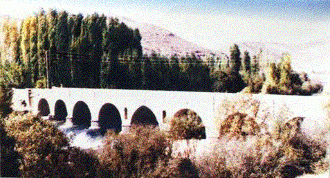
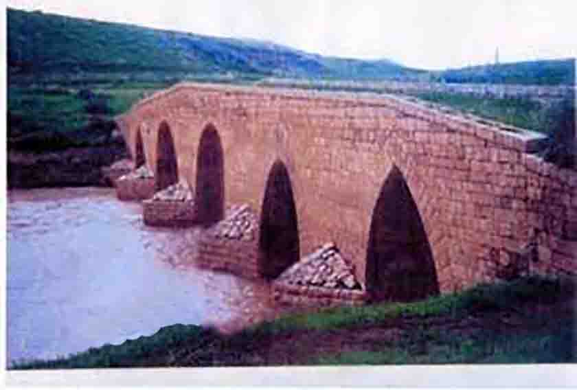
✅ پل طرق
پل طرق از شاخصترین پلهای تاریخی کشفرود بوده است که در دوره صفویه ساخته شد و در دوران قاجار چندین بار مرمت گردید. این پل آجری با طاقهای جناغی زیبا، محل عبور کاروانهای جاده تاریخی نیشابور به توس بوده است. این پل بر کال طرق نزدیک به خواجه اباصلت است و در نزدیکی پارک جنگلی غدیر قرار دارد.
موقعیت: حاشیه رباط طرق در شرق مشهد، محله ایوان، کنارگذر آزادراه شهید شوشتری
وضعیت کنونی: ثبت ملی شده و نیازمند مرمت اساسی برای استفاده گردشگری است.
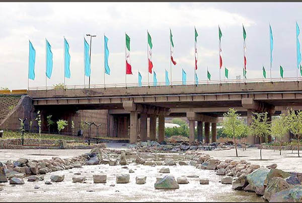
✅ پل فردوسی (پل شاهنامه)
_qmj9.jpg)
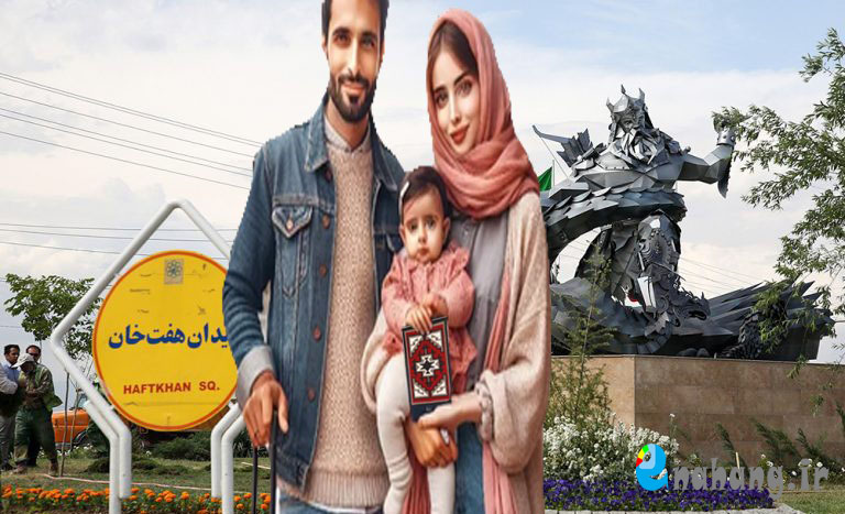
این پل بتنی مدرن در دهههای اخیر ساخته شده تا بلوار شاهنامه را از روی کشفرود عبور دهد و دسترسی مستقیم زائران و گردشگران را از شهر مشهد به آرامگاه فردوسی در توس فراهم کند. این پل با موقعیت استراتژیک خود، بخش مهمی از طرح «حرم تا توس» محسوب میشود. در نزدیکی این مکان از میدان هفت خان تا آرامگاه فردوسی اماکن دیدنی زیادی مانند موزه نان، موزه شاه لافتی، بقعه هارونیه، شهربازی پارک، پارک کالیگرافی فردوسی، حوض نیلوفر و آرامگاه فردوسی قرار دارد.
موقعیت: امتداد بلوار شاهنامه، شهر توس (محدوده چهاربرج و کلاتهبرفی) تا آرامگاه فردوسی
ویژگی: دسترسی سریع گردشگران از مرکز مشهد به میراث فرهنگی توس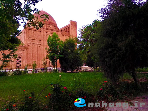
✅ پل شاهی
در مسیر خواجه ربیع مشهد به جاده کلات قرار دارد. در کنار بقایای تاریخی این پل که مربوط به دوره تیموری است، پلی بتنی ساخته شده است که در مسیر ارتباطی توس به کلات نادری و درگز نزدیک مشهد احداث شده است.
پل شاهی مشهد که بر روی کشفرود قرار داشت، دارای طاقهای جناغی بود و در دوره تیموری ساخته شد و در دورههای صفویه و قاجاریه تعمیراتی روی آن انجام گرفت. این پل به دلیل طغیان رودخانه در سالهای ۱۳۶۰ و ۱۳۷۵ به طور کامل تخریب شد.
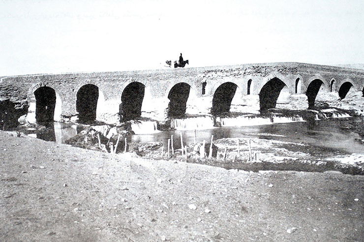
موقعیت: نزدیک بقعه خواجه ربیع
✅ پل چشمه گیلاس
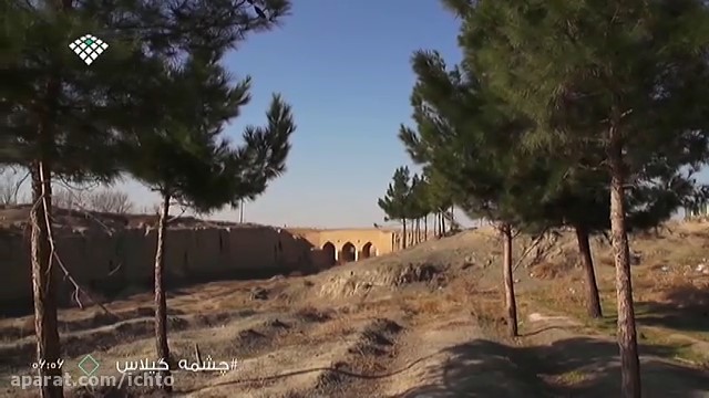
پل تاریخی در کنار درختان سردسیر کاج. این پل در سال 1386 ثبت ملی شده است.
موقعیت: روستای چشمه گیلاس چناران و در مسیر جاده قوچان- شاهنامه 14، دشت کوه های هزار مسجد
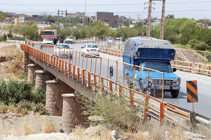
✅ پل پلنگآباد (پل قوچان)
این پل تاریخی در شمالغرب مشهد و نزدیک جاده قدیم قوچان ساخته شده و قدمت آن به دوره قاجار میرسد. پل پلنگآباد با دهانههای آجری و مصالح محلی، مقاومت خوبی در برابر سیلابهای فصلی کشفرود دارد.
موقعیت: نزدیکی روستای پلنگآباد، مسیر مشهد ـ قوچان
کارکرد فعلی: عبور محلی و دسترسی به زمینهای کشاورزی
✅ پل خلیج فارس- پل کشفرود در بزرگراه پیامبر اعظم (حدفاصل کمربند شمالی)
پل آن در نزدیکی بزرگراه پیامبر است. نام این پل، خلیج فارس است.
موقعیت: شمال مشهد، شاندیز
کاربرد: ترافیک عبوری شمال شهر
✅ پل خاتون کشفرود
این پل در محل تلاقی کشفرود و
هریرود واقع شده و از اهمیت تاریخی و باستانی برخوردار است. پل خاتون به
عنوان یکی از گذرگاههای جاده ابریشم در گذشته استفاده میشده است.
موقعیت:
این پل با طول ۸۰ متر و عرض ۶.۲ متر بر روی رودخانه هریرود ساخته شده و دارای پنج دهانه با طاقهای گهوارهای و جناقی است. پل خاتون در فاصله ۹۰ کیلومتری از مرکز سرخس واقع شده و به عنوان یک گذرگاه تاریخی در جاده ابریشم شناخته میشود. بازدید از این پل رایگان است و بهترین زمان برای بازدید روز است.
✅ پلهای مدرن در بافت شهری مشهد
همزمان با توسعه شهر، چندین پل مدرن بر بستر کشفرود ساخته شد که از مهمترین آنها میتوان به موارد زیر اشاره کرد:
✅ پل دهرود
پل با عرشه تیر بتنی در دهانه متوسط و دو دهانه 22 متری در طرفین، در مجموع به طول 70 متر روی کشفرود احداث شده است.
موقعیت: شمال شرق مشهد، منطقه دهرود و رسالت مشهد
کاربرد: ترافیک عبوری شمال شرق شهر
✅ پل کشفرود در بلوار طبرسی شمالی
موقعیت: اتصال خیابان طبرسی به بلوار توس، نزدیک ایستگاه مترو طبرسی
کاربرد: تسهیل عبور خودروها از شمال به غرب مشهد
✅ پل کشفرود در التیمور-پنجتن
پایه های پل همچنان باستانی مانده اند.
موقعیت: اتصال خیابان پنج تن و التیمور در مسیر بازار شهید شوشتری و طبرسی
کاربرد: تسهیل عبور خودروها از شمال به جنوب مشهد
✅ پل کشفرود در عسگریه
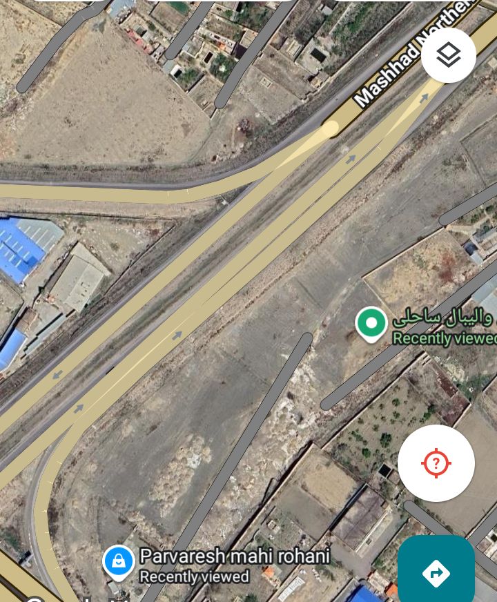
موقعیت: در محل پرورش ماهی و جایگاه سوخت علی آبادی
کاربرد: تسهیل عبور خودروها از کمربند شمالی به کمربند جنوبی مشهد
از نظر زیبایی شناختی دوار طراحی شده و در صورت جاری شدن رود تصویر نیم دایره آن با انعکاس آن در آب یک دایره میسازد.
✅ پل چهل بازه
موقعیت: وکیل آباد
کاربرد: تسهیل عبور خودروها
از نظر زیبایی شناختی در کنار رودپارک چهل بازه تعریف شده است
✅ پلهای روستایی حاشیه کشفرود
در مناطق روستایی مانند نصرآباد، حصارسرخ و مناطق کشاورزی شرق توس، پلهای کوچکتری در دهه ۱۳۴۰ و ۱۳۵۰ ساخته شدهاند تا عبور محلی مردم و دامها را تأمین کنند. هرچند این پلها از نظر معماری برجسته نیستند، اما در مدیریت بحران و سیلاب اهمیت بالایی دارند.
اهمیت گردشگری پلهای کشفرود
پلهای تاریخی و مدرن کشفرود بهویژه پل شاهی و پل فردوسی، ظرفیت بالایی برای معرفی به گردشگران دارند:
✔️ در مسیر مستقیم «حرم تا توس» واقع شدهاند
✔️ به مراکز مهم زیارتی و فرهنگی نزدیک هستند
✔️ دسترسی راحت از بزرگراهها و مسیرهای شهری دارند
✔️ چشمانداز زیبایی از کشفرود و دشت توس پیش چشم بازدیدکنندگان قرار میدهند
چنانچه عملیات مرمت و معرفی این پلها تکمیل شود، میتوانند بخشی از مسیر گردشگری منسجم مشهد ـ توس را تشکیل دهند و تصویر بهتری از میراث مهندسی آبی خراسان به گردشگران ارائه کنند.
__________________
Kashafrud River Bridges; Historical Arteries of Khorasan in Mashhad
Kashafrud is derived from the ancient name Kashaf, meaning turtle. In Shahnameh, Ferdowsi introduced it as Kase-rud. This name was chosen due to the clay nature of the riverbed.
The Kashfrud River originates from the slopes of Binalod and Hezarmasjid and flows in the northern and northeastern direction of Mashhad. Over the centuries, this river has played a key role in the formation of villages and the historical development of the Toos Plain, and numerous bridges have been built on its bed, which well reflect the cultural and civilizational identity of the region.
On this route, there are many historical and modern bridges, each of which has a specific engineering, social, and tourism value. The most important bridges of Kashfrud are:
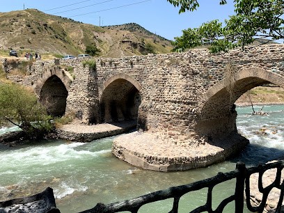
✅ Torgh Bridge
Torgh Bridge is one of the most significant historical bridges of Kashfrud, which was built during the Safavid period and was renovated several times during the Qajar era. This brick bridge with beautiful truss arches was the crossing point for caravans on the historic road from Neyshabur to Toos. The bridge is close to Khajeh Abaslat and is located near Ghadir Forest Park.
Location: On the outskirts of Robat Toqh in eastern Mashhad, Evan neighborhood, by the Shahid Shushtari Freeway
Current status: Nationally registered and in need of major renovation for tourism use.
✅ Ferdowsi Bridge (Shahnameh Bridge)
This modern concrete bridge was built in recent decades to cross Shahnameh Boulevard over the Kashf Rud and provide direct access for pilgrims and tourists from Mashhad to the Ferdowsi tomb in Toos. With its strategic location, this bridge is considered an important part of the "Harem to Toos" project.
Near this place, from Haft Khan Square to Ferdowsi's tomb, there are many places of interest, such as the Bread Museum, Shah Lafati Museum, Harunieh Tomb, Park Amusement Park, Ferdowsi Calligraphy Park, Lotus Pond, and Ferdowsi's tomb.
Location: Extension of Shahnameh Boulevard, Toos city (Chahar Borj and Kalateh Barfi area) to the Ferdowsi tomb
Feature: Quick access for tourists from the center of Mashhad to Toos cultural heritage
✅ Shahi Bridge
Is located on the way to Khajeh Rabi Mashhad to Kalat Road. Alongside the historical remains of this bridge, which dates back to the Timurid period, a concrete bridge has been built on the Toos-Naderi Kalat and Dargaz road near Mashhad.
Location: Near the Khwajeh Rabi Mausoleum
✅ Cheshme Gilas Bridge
A historic bridge next to the cold region pine trees. This bridge was nationally registered in 2007.
Location: Cheshme Gilas village, Chenaran, on the Quchan-Shahnameh 14 road, Hezar Masjid Mountains Plain
✅ Palangabad Bridge (Quchan Bridge)
This historic bridge was built northwest of Mashhad, near the old Quchan road, and dates back to the Qajar period. Palangabad Bridge, with its brick openings and local materials, has good resistance to the seasonal floods of the Kashfrud River.
Location: Near Palangabad village, Mashhad-Quchan route
Current function: Local crossing and access to agricultural lands
✅ Persian Gulf Bridge - Kashf Rud Bridge on the Prophet Azam Highway (Northern Beltway)
The bridge is near the Prophet Highway. The name of this bridge is Persian Gulf.
Location: North of Mashhad, Shandiz
Application: Traffic passing through the north of the city
✅ Khatoon Bridge of Kashfrud
This
bridge is located at the confluence of Kashfrud and Harirod and has
historical and ancient importance. Khatoon Bridge was used as one of the
crossings of the Silk Road in the past.
Location:
This
bridge is 80 meters long and 6.2 meters wide and was built on the
Harirod River and has five spans with barrel and lancet arches. Khatoon
Bridge is located 90 kilometers from the center of Sarakhs and is known
as a historical crossing on the Silk Road. Visiting this bridge is free
and the best time to visit is during the day.
✅ Modern bridges in the urban fabric of Mashhad
Along with the development of the city, several modern bridges were built on the Kashaf Rud River, the most important of which are the following:
✅ Dehrud Bridge
A bridge with a concrete beam deck in the middle span and two 22-meter spans on both sides, with a total length of 70 meters, has been built over the Kashafrud River.
Location: Northeast Mashhad, Dehrud and Resalat areas of Mashhad
Application: Traffic passing through the northeast of the city
✅ Kashaf Rud Bridge on North Tabarsi Boulevard
Location: Connecting Tabarsi Street to Toos Boulevard, near Tabarsi Metro Station
Application: Facilitating the passage of vehicles from the north to the west of Mashhad
Kashfrud Bridge in Al-Timur-Panjtan
Kashfrud-Panjtan Bridge
The foundations of the bridge are still ancient.
Location: Connecting Panjtan and El-Timur Streets on the way to Shahid Shushtari and Tabarsi Bazaar
Use: Facilitating the passage of vehicles from north to south of Mashhad
✅ Kashfrud Bridge in Asgariya
Northern Belt Road Bridge over Kashaf-rud
Location: At the fish farm and Aliabadi gas station
Use: Facilitating the passage of vehicles from the northern belt to the southern belt of Mashhad
It is aesthetically designed as a circle, and when the river flows, its semicircular image forms a circle with its reflection in the water.
✅ Rural bridges on the banks of the Kashf Rud
In rural areas such as Nasrabad, Hesar Sarkh, and the agricultural areas east of Toos, smaller bridges were built in the 1960s and 1970s to provide local passage for people and livestock. Although these bridges are not architecturally outstanding, they are of great importance in crisis and flood management.
The importance of tourism of Kashaf-Rud bridges
The historical and modern Kashaf-Rud bridges, especially the Shahi Bridge and the Ferdowsi Bridge, have a high potential for introduction to tourists:
✔️ They are located on the direct route from the Imam Reza Holy shrine to Toos
✔️ They are close to important pilgrimage and cultural centers
✔️ They have easy access from highways and urban routes
✔️ They offer visitors a beautiful view of the Kashaf-Rud and Toos Plain
If the restoration and introduction of these bridges is completed, they can form part of the integrated Mashhad-Toos tourism route and provide tourists with a better picture of Khorasan's hydraulic engineering heritage.
پلهای رودخانه جاجرود؛ میراثی از صفویه تا امروز
رودخانه جاجرود، یکی از مهمترین و پرآبترین رودهای شرق تهران، در طول مسیر خود شاهد احداث پلهای تاریخی و مدرن بسیاری بوده که هویت فرهنگی و تمدنی این منطقه را شکل دادهاند. این پلها علاوه بر نقش حملونقل و اتصال روستاها، دارای اهمیت تاریخی و معماری ارزشمندی هستند. در ادامه به معرفی مهمترین پلهای رودخانه جاجرود میپردازیم:
✅ پل شاهعباسی جاجرود
این پل تاریخی متعلق به دوره صفویه است و در مسیر جاده قدیم خراسان، روی رودخانه جاجرود ساخته شده. پل شاهعباسی با ۶ دهانه آجری و طاقهایی با قوسهای جناغی، شاهکاری از مهندسی ایرانی در قرن ۱۱ هجری شمسی محسوب میشود. این پل محل عبور کاروانها و راهیان سفر به خراسان بوده و همچنان استحکام خوبی دارد. پل شاهعباسی در نزدیکی روستای جاجرود واقع شده و در فهرست آثار ملی ایران به ثبت رسیده است.
مسیر دسترسی: حدود ۲ کیلومتر پس از خروجی جاده لشگرک به سمت روستای جاجرود
✅ پل لشگرک
پل لشگرک از پلهای باستانی و مهم محدوده شمال شرق تهران است. این پل بر رودخانه جاجرود احداث شده و دسترسی روستاها و ییلاقهای لواسانات را تأمین میکند. قدمت آن به دوره قاجار نسبت داده میشود و دارای معماری سادهتر و مصالح سنگ و آجر است.
مسیر دسترسی: ۴ کیلومتری شرق میدان لشگرک
✅ پل سد لتیان
همزمان با احداث سد لتیان در دهه ۱۳۴۰ خورشیدی، پلی برای عبور و مرور روی تاج سد ساخته شد که همچنان یکی از مسیرهای عبوری مهم شرق تهران به شمار میآید. این پل مناظر زیبایی از دریاچه سد و کوههای اطراف را پیش چشم رهگذران میگذارد و نقطه محبوبی برای عکاسان طبیعت است.
مسیر دسترسی: مسیر سد لتیان از جاده لشگرک به لواسان
✅ پل روستای خرمدشت
پل خرمدشت در جنوب شرق سد لتیان و در حوالی روستای خرمدشت قرار دارد. این پل در دهه ۱۳۵۰ ساخته شده و ارتباط زمینهای کشاورزی دو سوی رودخانه را برقرار میکند. هرچند از نظر معماری شاخص نیست، اما ارزش اجتماعی بالایی برای ساکنان منطقه دارد.
✅ پل روستای مهرآباد
پل مهرآباد با سازهای بتنی در مسیر روستای مهرآباد ساخته شده و در فصلهای پرآب اهمیت زیادی برای عبور دام و محصولات کشاورزی دارد.
✅ پلهای فرعی پاییندست جاجرود
در بخش جنوبی رودخانه جاجرود و نزدیکی حریم شهری تهران، چندین پل فرعی دیگر ساخته شدهاند که بیشتر کاربرد محلی داشته و با افزایش شهرنشینی تهران و گسترش محدوده شهری، اهمیت ارتباطی بیشتری پیدا کردهاند.
پیشنهاد گردشگری برای علاقمندان
اگر به تهران سفر کردید یا ساکن آن هستید و میخواهید جاجرود را با دید تاریخی و طبیعی کشف کنید، این پلها را میتوانید در یک تور گردشگری نیمروزه یا یکروزه بگنجانید:
✔️ پل شاهعباسی جاجرود + پیادهروی در مسیر روستای جاجرود
✔️ بازدید از پل لشگرک + طبیعتگردی در اطراف سد لتیان
✔️ عکاسی از پل سد لتیان + قایقسواری یا پیکنیک در حاشیه دریاچه
✔️ پلهای روستایی خرمدشت و مهرآباد + تجربه فرهنگ روستایی و محصولات محلی
به این ترتیب هم لذت دیدن معماری تاریخی را میبرید، هم با مردم محلی و طبیعت بکر منطقه آشنا میشوید.
_________________
Bridges of the Jajrud River; A Legacy from the Safavids to Today
The Jajrud River, one of the most important and most water-rich rivers in eastern Tehran, has witnessed the construction of many historical and modern bridges along its route that have shaped the cultural and civilizational identity of this region. In addition to their role as transportation and connecting villages, these bridges have valuable historical and architectural significance. Below, we will introduce the most important bridges of the Jajrud River:
✅ Shah Abbasi Bridge, Jajrud
This historical bridge dates back to the Safavid era and was built on the Jajrud River along the old Khorasan road. With 6 brick spans and arches with truss arches, the Shah Abbasi Bridge is considered a masterpiece of Iranian engineering in the 11th century AH. This bridge was a crossing point for caravans and travelers traveling to Khorasan and is still very strong. The Shah Abbasi Bridge is located near the village of Jajrud and has been registered on the list of national monuments of Iran.
Access route: About 2 km after the exit of Lashgarak Road towards Jajrud village
✅ Lashgarak Bridge
Lashgarak Bridge is one of the ancient and important bridges in the northeast of Tehran. This bridge was built on the Jajrud River and provides access to the villages and summer cottages of Lavasanat. Its history is attributed to the Qajar period and has a simpler architecture and stone and brick materials.
Access route: 4 km east of Lashgarak Square
✅ Latian Dam Bridge
At the same time as the construction of Latian Dam in the 1960s, a bridge was built to cross and navigate over the dam crest, which is still one of the important passageways in eastern Tehran. This bridge offers beautiful views of the dam lake and the surrounding mountains to passersby and is a popular spot for nature photographers.
Access route: Latian Dam route from Lashgarak Road to Lavasan
✅ Khorramdasht Village Bridge
Khorramdasht Bridge is located southeast of Latian Dam and near Khorramdasht Village. This bridge was built in the 1970s and connects agricultural lands on both sides of the river. Although it is not architecturally significant, it has high social value for the residents of the area.
✅ Mehrabad Village Bridge
Mehrabad Bridge was built with a concrete structure on the route to Mehrabad Village and is of great importance for the passage of livestock and agricultural products during high water seasons.
✅ Subsidiary bridges downstream of Jajrood
Several other subsidiary bridges have been built in the southern part of the Jajrood River and near the urban area of Tehran, which are mostly used locally and have gained greater communication importance with the increase in urbanization in Tehran and the expansion of the urban area.
Tourism suggestion for enthusiasts
If you have traveled to Tehran or are a resident of it and want to explore Jajrud from a historical and natural perspective, you can include these bridges in a half-day or one-day tourist tour:
✔️ Shah Abbasi Bridge in Jajrud + Walking along the Jajrud village path
✔️ Visiting Lashgarak Bridge + Nature tourism around Latian Dam
✔️ Photographing Latian Dam Bridge + Boating or picnicking on the lakeside
✔️ Rural bridges of Khorramdasht and Mehrabad + Experiencing rural culture and local products
In this way, you will both enjoy seeing historical architecture and get to know the local people and the pristine nature of the region.