Kashafrud river - رودخانه کشف رود
اینجا درباره رودخانه کشفرود ایران مینویسمKashafrud river - رودخانه کشف رود
اینجا درباره رودخانه کشفرود ایران مینویسمدرباره من
 از اونهام که می گم آدم بایست حرف خودشو بزنه، اما یاد گرفتم که هر حرفی رو تو جاش بزنم، اینجا، هرچی می خوام رو می گم
ادامه...
از اونهام که می گم آدم بایست حرف خودشو بزنه، اما یاد گرفتم که هر حرفی رو تو جاش بزنم، اینجا، هرچی می خوام رو می گم
ادامه...
از بید زرد تا نخل خرما در سیستان و بلوچستان
زردبید و زرآبادی
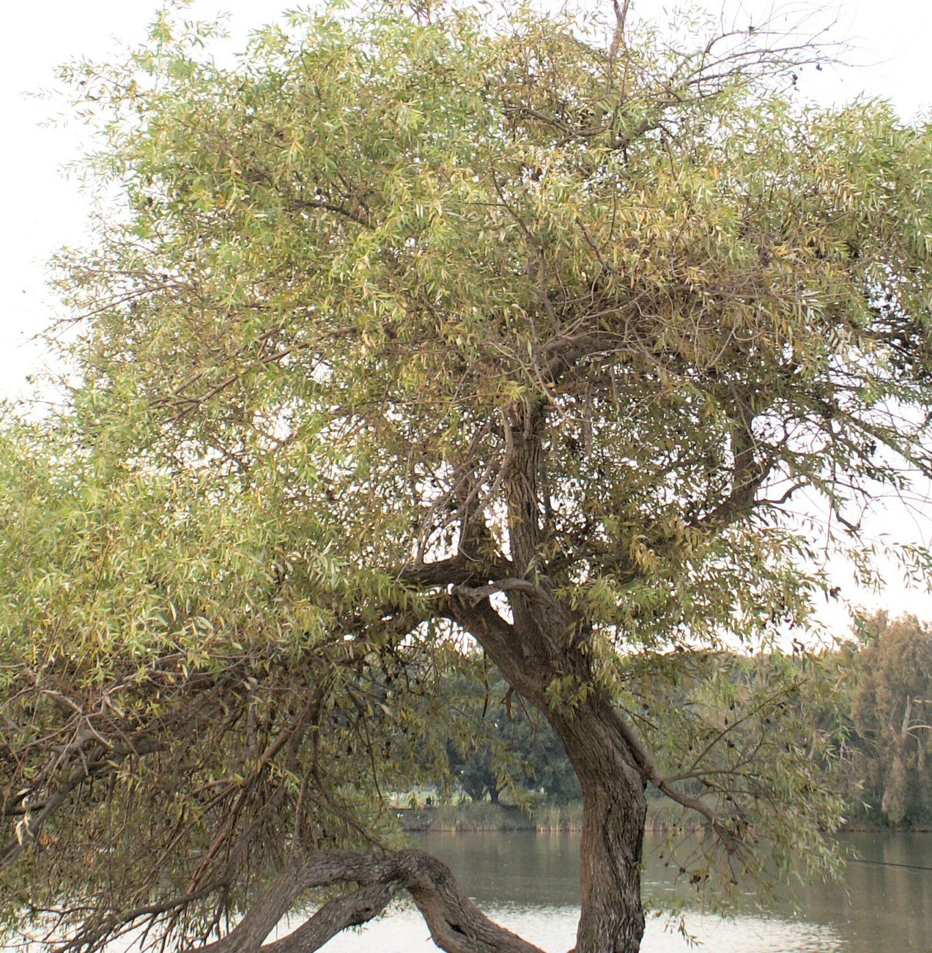
در کتابی درباره زردبید خواندم که این درخت ایرانی است و در سیستان و بلوچستان هم یافت میشود. زردبید، بیدِزرد یا بید ایرانی (نام علمی: Salix acmophylla) گونهای از بید است که در ایران، افغانستان، پاکستان، ترکمنستان، عراق، سوریه، فلسطین و لبنان، و مصر یافت میشود. زرد بید یکی از گونه های درخت بید است. همانطور که درخت بید سفید، بید سیاه و بید معلق داریم، بید زرد نیز داریم. برگهای این درخت با درخت زبان گنجشک شباهت دارند.
در سیستان و بلوچستان بید زرد یافت میشود. سیستان و بلوچستان با کلماتی مثل زر و زردچوبه استانی برای پیدا کردن گونه های مختلف درختی است که اتفاقا باید زرد و زر اندود (مثل خوشه های گندم) بوده باشند. جنگل های پراکنده ای این استان دارد که به تراکم جنگل های هیرکانی شمال نیست. کنجکاو شدم ببینم در کدام شهر از این استان زرد بید داریم.
نگاه کردم زرآباد و شهرهای اطراف سنگان، سیاه جنگل بالا و اطراف آنها1 و خیلی شهرهای دیگر این استان باید از این درخت داشته باشند.
از آنطرف یک نگاهی هم به سایت ها و وبلاگ ها انداختم تا ببینم نتیجه تجربه بقیه در این زمینه چه بوده که متاسفانه مطلب درخور توجهی در این زمینه پیدا نکردم که بلکه بدتر، یک مطلب دیدم که تبلیغ چوب زردبید برای قلیان میکرد و مطلب دیگری لیست بلند بالایی از درختان بومی سیستان و بلوچستان ایران داده بود که در آنها نامی از زردبید و از همه مهم تر درخت نخل خرمایی که خیلی در سیستان و بلوچستان مشهور هم هست برده نشده است. در عوض اسم درخت کهور آمریکایی را آورده بود که میگویند کاشت آن باعث دردسر شده و بسیار آلرژی زاست!
پوشش گیاهی سیستان و بلوچستان در ترکیب با درخت نخل بهتر میشود و این درخت بومی این منطقه است. درخت نخل از گونه درختان میوه است، آسوریک2 در ایران کهن، در جنوب این درخت
را مُغ مینامید. این درخت را چهارفصل میشناسند؛ زیرا همیشه سبز بوده و
قدمت بالایی دارد. خرما یکی از محصولات صادراتی ایران و محبوب است و رقیبی مثل مصر دارد.
پتانسیل گردشگری و منابع طبیعی سیستان و بلوچستان بعنوان یکی از استانهای جنوبی کشور ایران از دید مردم شهرهایی مثل کرمان، بندرعباس و اهواز و حتی شهرهای خراسان جنوبی بیشتر قابل درک و تشخیص است. از این حیث رونق اقتصادی سایر شهرهای جنوبی موجب آبادانی بیشتر این استان و توسعه گردشگری آن میشه.
___________________
1- تا چاهان نیک شهر که ارتفاعات خوبی هم دارد احتمال میدهم این درخت یافت شود. از روی نقشه نگاه کردم ارتفاعاتش هم جالب بود که فکر میکنم انتخاب این نام بی ارتباط با آن ارتفاعات نبوده باشد. زیبایی های خداوند حد و نهایت ندارد. فکر کنم ارتفاعاتش تا 900 متر برسد.
_vbd.jpg)
2- درخت آسوریک: درخت آسوری یا درخت آسوریگ کتابیست نوشتهشده به زبان پارتی و خط پهلوی.
______
Zardbid and Zarabadi
Yellow Willow
I read in a book about yellow willow that this tree is Iranian and is also found in Sistan and Baluchestan. Yellow willow, (Zardbid) or Iranian willow (scientific name: Salix acmophylla) is a species of willow found in Iran, Afghanistan, Pakistan, Turkmenistan, Iraq, Syria, Palestine and Lebanon, and Egypt. Yellow willow is a species of willow tree. Just as we have white willow, black willow and hanging willow, we also have yellow willow. The leaves of this tree are similar to the ash tree.
Yellow willow is found in Sistan and Baluchestan. Sistan and Baluchestan is a province with words like zar and zarchobe to find different species of trees that should have been yellow and gold-plated (like wheat ears). This province has scattered forests that are not as dense as the Hyrcanian forests in the north. I was curious to see in which city of this province we have yellow willow.
I looked at Zarabad and the cities around Sangan, Siah Jangal Bala and their surroundings1 and many other cities in this province should have this tree.
From there, I took a look at the sites and blogs to see what the results of others' experiences in this field were, but unfortunately I did not find any noteworthy articles in this field. Even worse, I saw an article that advertised Zardbid wood for hookahs and another article gave a long list of trees native to Sistan and Baluchestan, Iran, in which Zardbid and most importantly the date palm tree, which is also very famous in Sistan and Baluchestan, were not mentioned. Instead, they mentioned the name of the American melon tree, which they say is troublesome to plant and is highly allergenic!
The vegetation of Sistan and Baluchestan improves in combination with the palm tree, and this tree is native to this region. The palm tree is a type of fruit tree, and the Assyrians2 in ancient Iran called this tree Mogh in the south. This tree is known as the Four Seasons because it is evergreen and has a long history. Dates are one of Iran's popular export products and have a competitor like Egypt.
The tourism potential and natural resources of Sistan and Baluchestan, as one of the southern provinces of Iran, are more understandable and recognizable from the perspective of the people of cities such as Kerman, Bandar Abbas, and Ahvaz, and even the cities of South Khorasan. In this regard, the economic prosperity of other southern cities will lead to further development of this province and the development of its tourism.
___________________
1- I think this tree can be found near Chahan Nikshahr, which also has good altitudes. I looked at the map and its altitudes were also interesting, so I think the choice of this name was not unrelated to those altitudes. God's beauties have no limits. I think its altitudes can reach up to 900 meters.
Sistan and Baluchestan
2- The Assuric Tree: The Assuric Tree or Assurig Tree is a book written in the Parthian language and Pahlavi script.
آلودگی هوا و پرندگان کشفرود
استاندار خراسان رضوی با تأکید بر ضرورت مدیریت آلودگی هوا و
کاهش استفاده از سوخت مازوت در نیروگاهها گفت: مشهد به عنوان کلانشهری با
جمعیتی بیش از ۲۲ استان کشور، امروز درگیر ریزگردها و آلاینده های شدید
است. ساماندهی رودخانه تاریخی کشفرود نیز به یکی از اولویتهای زیستمحیطی
استان بدل شده است.
حدود ۳۰ سال است که رودخانه کشفرود دستخوش
تجاوز انسان شده و مسیر آن با ساخت و سازهای در مبدا شاندیز و بالادست
کشفرود در مسیر کوه های هزار مسجد تخریب شده است. همچنین، جریان آن با
تخریب چشمه هایی که آب آنها قرار بوده به کشفرود بریزد، کم شده است.
آلودگی
محیط زیست و به ویژه آلودگی هوا توسط فلزات سنگین مثل سرب و آلومینیوم،
جان پرندگان مهاجر و آبزیان و نیز مردم اهالی اطراف کشفرود را به مخاطره می
اندازد. نیروگاه توس که قبلا مازوت سوزی آن با دستور دادستانی ممنوع شده
بود، با آغاز به کار دولت پزشکیان دوباره مازوت سوزی را از سر گرفته و با
آغاز فصل سرد، زمانی که پرندگان محدودیت های غذایی نیز دارند میزان مازوت
سوزی تشدید شده است. گفتنی است مازوت سوزی منحصر به فصل سرد سال نبوده و ما
حتی در تابستان نیز برای تامین انرژی شاهد این مشکل بوده ایم. حداقل
خواسته طرفداران محیط زیست این است که گوگردزدایی در سوخت مازوت صورت گیرد،
اما این حداقل ها نیز رعایت نمیشود تا هوا هر روز خاکستری تر و غبار
بیماری و آزار در چهره ساکنان شهر بیشتر شود.
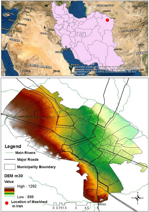
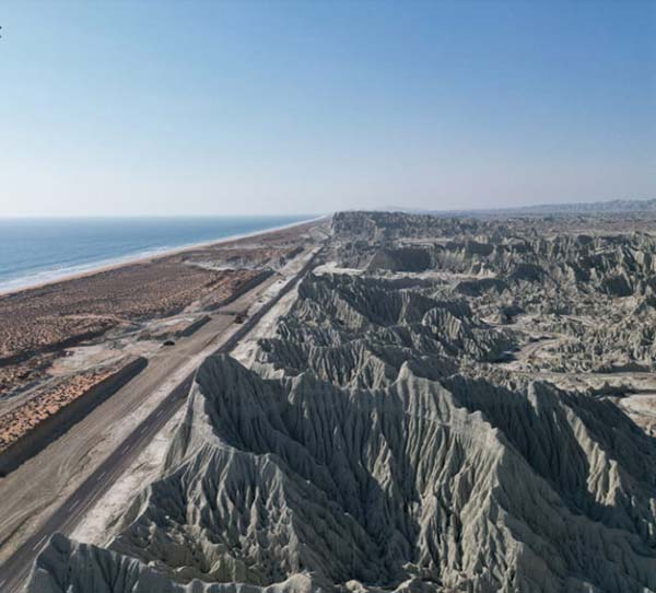
در تصویر، گوشه سمت چپ، بالا نیروگاه توس قرار دارد. اثر تجمعی آلایندگی آن را از مقادیر زیاد (بیش از 1000) تا کم (900) از گوشه چپ تا نواحی جنوبی شاهد هستیم. نیروگاه توس در هشت کیلومتری پل فردوسی کشفرود قرار دارد.
دهه های گذشته، برخی پژوهشها احتمال داده اند که تجمع آلومینیوم در مغز ممکن است با بیماری آلزایمر مرتبط باشد. اگرچه هنوز این رابطه قطعی ثابت نشده، ولی نگرانیهایی در این زمینه باقی مانده است. کلیه ها نقش مهمی در دفع فلزات سنگین مانند آلومینیوم دارند. در بیمارانی که دچار نارسایی کلیوی هستند، احتمال تجمع آلومینیوم در بدن و بروز مشکلات استخوانی یا عصبی بیشتر است.

میزان مسمویت جانداران مختلف بسته به جثه آنها توسط این آلاینده ها متفاوت است. مثلا پرندگان که جثه کوچکتری دارند بیشتر از این آلاینده ها مسموم میشوند و اغلب پرندگانی را در زمستان میبینیم که فکر میکنیم دچار یخ زدگی شده، به زمین افتاده و مرده اند. در واقع آنها این آلاینده ها را در فصل تابستان به صورت ذخیره شده درکنار ذخایر انرژی خود نگه داشته و در زمستان که نیاز به انرژی دارند و بدن آنها برای تامین انرژی به چربی سوزی روی می آورند، دچار مسمویت تابستانه شده و از بین میروند. این مسمویت برخلاف اینکه به نظر میرسد، مربوط به آغاز سرما نیست، بلکه به خاطر مصرف مواد مسموم و آلاینده ها در تابستان و قبل از آن اتفاق افتاده است.
_________________
The
governor of Khorasan Razavi, emphasizing the need to manage air
pollution and reduce the use of diesel fuel in power plants, said:
Mashhad, as a metropolis with a population of more than 22 provinces in
the country, is currently struggling with fine dust and severe
pollutants. Organizing the historic Kashfrud River has also become one
of the province's environmental priorities.
The Kashfrud
River has been encroached upon by humans for about 30 years, and its
course has been destroyed by construction at the source in Shandiz and
upstream of Kashfrud on the way to the Hezar Masjid Mountains. Also, its
flow has decreased due to the destruction of springs whose water was
supposed to flow into Kashfrud.
Environmental pollution,
especially air pollution by heavy metals such as lead and aluminum,
endangers the lives of migratory birds and aquatic animals, as well as
the people living around Kashfrud. The Toos Power Plant, which had
previously been banned from burning diesel fuel by order of the
prosecutor's office, resumed burning diesel fuel with the start of the
Pezizian government, and with the onset of the cold season, when birds
also have food restrictions, the amount of diesel fuel burned has
intensified. It is worth noting that diesel fuel burning is not limited
to the cold season of the year, and we have witnessed this problem even
in the summer for energy supply. The minimum demand of environmentalists
is that desulfurization be carried out in diesel fuel, but these
minimums are not met, so that the air becomes grayer every day and the
dust of illness and annoyance increases in the faces of city residents.
Toos Power Plant - Mashhad Air Pollution
In
the picture, in the upper left corner, the Toos Power Plant is located.
We can see the cumulative effect of its pollution from high levels
(more than 1000) to low levels (900) from the left corner to the
southern areas. Toos Power Plant is located eight kilometers from the
Ferdowsi Bridge in Kashfrud.
In the past
decades, some studies have suggested that aluminum accumulation in the
brain may be related to Alzheimer's disease. Although this relationship
has not yet been definitively proven, there are concerns about this. The
kidneys play an important role in excreting heavy metals such as
aluminum. In patients with kidney failure, the likelihood of aluminum
accumulating in the body and developing bone or nerve problems is
higher.
Fish-eating fish eating fish
The
degree of poisoning of different organisms by these pollutants varies
depending on their size. For example, smaller birds are more likely to
be poisoned by these pollutants, and we often see birds in winter that
we think have frozen, fallen to the ground, and died. In fact, they keep
these pollutants stored in the summer alongside their energy reserves
and in winter, when they need energy and their bodies turn to burning
fat for energy, they suffer from summer poisoning and die. Contrary to
what it seems, this poisoning is not related to the onset of cold
weather, but rather due to the consumption of toxic substances and
pollutants in the summer and before.
برنامه ریزی و سواحل دیدنی مکران
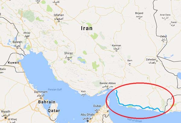
منطقه مکران با منابع طبیعی غنی، موقعیت مناسب برای شیلات، کشاورزی، استخراج معادن، و صنایع نفت و گاز، به یکی از قطبهای اقتصادی ایران تبدیل شده است. بندر چابهار، یکی از اصلیترین بندرهای ایران در این منطقه است که بهعنوان تنها بندر اقیانوسی کشور شناخته میشود و برنامههای توسعهای متعددی برای آن در حال اجراست.
مکران سرزمینی است که در آن تاریخ، طبیعت، و فرصتهای اقتصادی به هم پیوند خوردهاند. اگر به دنبال کشف زیباییهای بکر، سرمایهگذاری در آینده، یا آشنایی با تاریخی کهن هستید، مکران مقصد شماست. این منطقه شگفتانگیز، با تمام ظرفیتهایش، منتظر شماست تا داستانهای جدیدی را رقم بزند.
ساحل لاک پشت ها
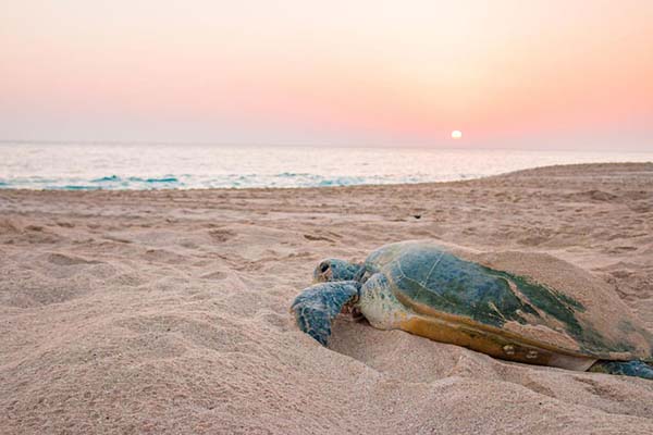
از مناطق ساحلی معروف مکران می توان به ساحل گواتر اشاره کرد که با اسم ساحل لاک پشت ها نیز شناخته می شود. این ساحل به دلیل حضور زیاد لاک پشت های دریایی، به یکی از زیباترین و محبوبترین مقاصد گردشگری ایران تبدیل شده است. همچنین ساحل لاک پشت ها در جزیره هرمز از زیباترین سواحل جنوب ایران به شمار می رود. نامگذاری این ساحل به دلیل حضور و فعالیت لاک پشت های دریایی است.
پهنه های مکران و شرق ایران، گسترده ترین ساحل صخره ای
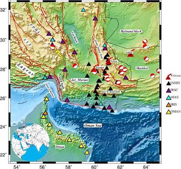
ﻓﻠــﯿﺶ ﻫــﺎی ﭘﻬﻨــﻪ ﻫــﺎی ﻣﮑــﺮان و ﺷــﺮق اﯾــﺮان ﮔﺴــﺘﺮده ﺗــﺮﯾﻦ واﺣــﺪﻫﺎی ﺳــﻨﮕﯽ اﺳــﺘﺎن ﺳﯿﺴــﺘﺎن و ﺑﻠﻮﭼﺴـﺘﺎن ﻣـﯽ ﺑﺎﺷـﻨﺪ. در امتداد محور لاس بلا، گسلهای چپگرد « چمن(Chaman Fault) » و «اُرناچ نال (Ornach Nal) معرف یک زون ترادیسی بین زون فرورانش مکران و زون برخوردی هند – اوراسیا است. گفتنی است که از 160 هزارکیلومتر مربع گسترة مکران، حدود 70 هزارکیلومتر مربع آن در ایران و بقیه در پاکستان است.
پیسنگ این ناحیه نوعی پوستة اقیانوسی با میانگین ستبرای حدود 7 کیلومتر است که با توالی ستبری از رسوبهای فلیشگونه و گاه شبه مولاس پوشیده شده که ممکن است تا حدود 10هزار متر ضخامت داشته باشند. در یک راستای شمال به جنوب، پوشش رسوبی روی پیسنگ، جوانتر است. در شمالیترین بخش مکران مجموعهای از پوستههای اقیانوسی و رسوبات پلاژیک کرتاسة بالا رخنمون دارند که به طور عموم با ردیفهای فلیشی کرتاسة بالا – ائوسن پوشیده و یا در آمیختهاند. بخش میانی مکران با فلیشهای الیگوسن، با چند دگرشیبی موازی درون سازندی و یک دگرشیبی زاویهای در بالا، پوشیده شده است.
بدینسان، ساختار مکران، الگویی فلسی (Imabricated) دارد که فلسها با گسلهای معکوس پر شیب مرزبندی میشوند و فرجام آن رانـده شدن فلس از پسخشکـی (Hinterland (N-NE)) به سمت پیشخشکی (Foreland) (S - SW) است. این ساختار در اثر رویدادی پدید آمده است که اوج آن در میوسن بوده و از آن پس نیز با شدت کمتری همچنان ادامه دارد؛ زیرا که به لحاظ تداوم فرورانش، در ناحیة مکران، گسلها هنوز فعالاند و زمین به بالا آمدن ادامه میدهد که این عمل با چینخوردگی، کوتاهشدگی و با پسروی خط ساحلی همراه است.
گفتنی است که راندگیها سبب شدهاند تا پوستة مکران پنجاه تا هفتاد درصد کوتاه شود. عامل چینخوردگی، به طور عمده، فشارهای ناشی از فرورانش پوستة اقیانوسی عمان به زیر مکران است که با عملکرد گسلهای راندگی شدت مییابد، به گونهای که رویداد گسل آفرینی با چینخوردگی شدید پرکلینال با برتری الگوی جناغی همراه است. با توجه به زمان آغاز فرورانش، پدیدة چینخوردگی از کرتاسة پسین آغاز شده و هنوز هم ادامه دارد. از شمال به جنوب، شدت چینخوردگی کاهش مییابد، به گونهای که در مکران ساحلی چینخوردگی و گسلش معکوس وجود ندارند و یا بسیار ناچیز و اتفاقی هستند. «گسل» های مکران، از نظر زمان پیدایش و نقش، چند نوع هستند:
1- «گسلهای طولی(Longitudinal Faults) » که در آغاز از نوع گسلهای نرمال بوده و همزمان با شکلگیری حوضه به وجود آمدهاند ولی، در رژیمهای فشارشی بعدی به گسلهای راندگی با شیب تند به سمت شمال و شمال خاوری تبدیل شدهاند. از ادامة گسلها در ژرفا اطلاعی در دست نیست، ولی کینگ و همکاران (1975)، ادامةگسلها را تا عمق 20 کیلومتر میدانند.
2- «گسلهای مزدوج (Conjugated Faults) »، که از نظر روند و نوع به دو گروه قابل تقسیماند. گروه نخست، دارای روند شمال باختری هستند که سازوکار امتداد لغز راستگرد دارند. گروه دوم، دارای روند شمال خاوری با سازوکار حرکتی امتداد لغز چپگردند. گسلهای مزدوج، روند خاوری – باختری ساختارها را قطع میکنند و به یک همگرایی به طرف شمال، در داخل منشور برافزاینده اشاره دارند.
3- «گسلهای نرمال (Normal Fault)» که در ساحل مکران دیده میشوند. زمان پیدایش آنها کواترنر دانسته شده و پذیرفته شده است که خطی بودن حاشیة شمالی پادگانههای دریایی و همچنین، بالا آمدن سواحل مکران نتیجة عملکرد این گسلهاست و حرکتهای قائم این گسلها سبب شده تا پادگانههای دریایی در سطوح تراز گوناگون سامان گیرند.
مککال (1985)، پوستة قارهای موردنظر را ادامة جنوب خاوری زون سنندج – سیرجان، در پهنة مکران میداند. افتخارنژاد (گفتة شفاهی) این پوستة قارهای را جدا کنندة نوار افیولیتی بیرونی (Outer Axial Ophiolite Belt) از درونی (Inner Axial Ophiolite Belt) میداند. فرهودی و کریگ (1977) با توجه به روند فزایندة سن نهشتهها از جنوب به شمال، دگرشکلی موجود و فزونی گرفتن ارتفاع، مکران را نوعی سیستم کمانی جنبا (Active Arc System) دانستهاند که در شکلگیری آن، فرورانش پوستة اقیانوسی عمان به زیر مکران نقش بنیادی داشته است. به نظر ایشان، فرورانش در فاصله 400 کیلومتری از ساحل انجام گرفته و پیش از فرورانش، سنگکرة خمیده شده و ذوب پوستة اقیانوسی سبب شکلگیری سنگهای ماگمایی بلندیهای بزمان شده است. در این نظریه، پهنة مکران به دو واحد زمینساختی تقسیم شده است:
یکی بخش پایین افتادة جازموریان که نوعی حوضة پیش کمان در حال فرونشینی(Subsiding Fore Arc Basin) است و دیگری، بخش بالا آمدة جنوبی که از کوههای بشاگرد تا ژرفای اقیانوس عمان ادامه دارد و خود از دو بخش حوضة شیبSlope Basin) ) و پرشدگی ژرفنا (Trench Fill) تشکیل شده است.
پهنای شیب - ژرفنا حدود 300 کیلومتر است. بنابراین شیب ورق پاییــن رونده حدود یک درجه برآورد میشود. به عقیدة مککال (1985)، پهنة مکران شامل 4 ایالت زمینساختی جداگانه است:
1- گودال خشکیزایی جازموریان (Jaz – e – Murian Epirogenic Depression) ، با رسوبهای کواترنر پوشیده شده است. در بیشتر گزارشهای زمینشناسی موجود، این فرونشست را بخشی از ایران مرکزی و دنبالة بلوک لوت دانستهاند ولی برداشتهای ژئوفیزیک هوایی اخیر، گویای آن است که پیسنگ این فروافتادگی جوان، از نوع پوستههای افیولیتی است. این گونه حوضههای پیشکمانی در دیگر زونهای فرورانش نیز گزارش شده که گاه توانی شایان توجه از هیدروکربن دارند.
2- کافت فرعی یا زون گسترش کافت مانند(Rift Like Spreading Zone) ، این بخش در اواخر ژوراسیک یا اوایل کرتاسه شکل گرفته و تا اوایل ائوسن حوضة کافتی باریکی را تشکیل میداده است. در این بخش مجموعهای از سنگهای افیولیتی به همراه رسوبهای پلاژیک کرتاسة بالا و فلیشهای آهکی پالئوسن، به صورت مخلوط برونزد دارند.
3- زون کربناتی پیشکمانی(Carbonate Fore Arc) ، این بخش باریکهای از پوستة قارهای با سنگهایی از نوع سکوی قارهای است که گاه آن را بخش جدا شدة بلوک لوت و گاه ادامة زون سنندج – سیرجان میدانند.
4- زون ژرفنای اقیانوسی (Trench )»، این بخش، یک زون فرورانش واقعی با سنگهایی از مجموعههای افیولیتی و رسوبهای پلاژیک تریاس بالا – پالئوسن است. که با رسوبهای فلیشی – مولاسی پوشیده شده و تا ساحل مکران شامل چهار بخش است. الف) زون فلیشی ائوسن، ب) زون فلیشی الیگوسن – میوسن، ج) زون رسوبهای نریتیک میوسن، د) زون ساحلی با رسوبهای کم ژرفای مولاسی میوسن بالایی – پلیوسن .
چالش های آب و خاک ایران
تغییر کاربری اراضی، ضعف مواد آلی، تخلیه بنیه حاصلخیزی، بهرهبرداری نامتوازن از منابع خاک و آب و تخلیه سفرههای آب زیرزمینی همه مشکلات جدی این حوزه هستند که لازم است با نگاه فرابخشی برای آن تدبیر شود. تسهیلات اشتغالزا باید با نظارت فرمانداران اعطا شود و در این باره هیچ سهمیه خاصی برای فرمانداریها در حوزه اشتغال قائل نشوند. یکی از موضوعات مهم استان سیستان و بلوچستان آب است، بنابر این همه باید در این حوزه بسیج شده و به وظایف خود عمل کنند.
مکران بخش عمده این پهنه در جنوب سیستان و بلوچستان
محدوده جغرافیایی:
مکران در امتداد دریای عمان قرار دارد و بخشهایی از استانهای سیستان و بلوچستان و هرمزگان را شامل میشود. این منطقه از بندر جاسک در هرمزگان شروع شده و تا بندر گوادر در پاکستان امتداد دارد.
پتانسیل توسعه بندرگاهی و فرصتهای اقتصادی:
بندر چابهار در ایران و بندر گوادر در پاکستان، دو نقطه حیاتی در این منطقه هستند که در توسعه کریدورهای اقتصادی و تجاری مانند پروژه کریدور اقتصادی چین و پاکستان (CPEC) نقش بزرگی ایفا میکنند. این بنادر، فرصتهای بزرگی برای تجارت جهانی و توسعه اقتصادی فراهم کردهاند.
بررسی رسوب شناسی ساحل مکران
از منظر رسوبشناسی، سواحل دریای مکران دارای رسوبات غنی از مواد معدنی و آلی هستند که تحت تأثیر جریانات اقیانوسی و رسوبات رودخانهای شکل گرفتهاند. این رسوبات نقش کلیدی در پایداری ساحلی و تغذیه اکوسیستمهای دریایی ایفا میکنند. بررسیهای زمینشناسی نشان میدهد که رسوبات این منطقه شامل ماسههای ساحلی، گلولای رودخانهای، و ساختارهای رسوبی پیچیدهای است که به دلیل تلاقی جریانهای دریایی و رودخانهای ایجاد شدهاند.
بندر عباس و شیراز نقاط کلیدی تجارت و ترانزیت ایران
بندرعباس، با دسترسی مستقیم به خلیج فارس و دریای مکران، از ظرفیتهای بالایی برای تبدیل شدن به مرکز اداری و اقتصادی کشور برخوردار است. این شهر، به دلیل نزدیکی به آبهای آزاد و بنادر استراتژیک، میتواند نقطهای کلیدی در زنجیره تجارت و ترانزیت ایران باشد. از سوی دیگر، شیراز با زیرساختهای شهری پیشرفتهتر، موقعیت فرهنگی غنی، و اقلیم مناسبتر نسبت به بندرعباس، گزینهای جذاب برای انتقال پایتخت اداری و سیاسی به شمار میآید.
_____________________
آدرس ساحل لاک پشت ها (1): استان سیستان و بلوچستان، در ۱۵۰ کیلومتری جاده چابهار به گواتر
ساحل لاک پشت ها (2): استان هرمزگان، جزیره هرمز
Makran Coastline
With its rich natural resources, suitable location for fisheries, agriculture, mining, and oil and gas industries, the Makran region has become one of Iran’s economic hubs. Chabahar Port is one of the main Iranian ports in this region, known as the country’s only oceanic port, and numerous development programs are underway for it.
Makran is a land where history, nature, and economic opportunities are intertwined. If you are looking to discover pristine beauty, invest in the future, or get acquainted with ancient history, Makran is your destination. This amazing region, with all its potential, is waiting for you to create new stories.
Turtle Beach
Turtle Beach Sand
One of the famous coastal areas of Makran is Gowtar Beach, also known as Turtle Beach. This beach has become one of the most beautiful and popular tourist destinations in Iran due to the large presence of sea turtles. Also, Turtle Beach on Hormuz Island is considered one of the most beautiful beaches in southern Iran. This beach is named because of the presence and activity of sea turtles.
Makran and Eastern Iran’s most extensive rocky coast
Chabahar Rocky Coast
The flyschs of the Makran and Eastern Iran’s most extensive rocky units are the most extensive in Sistan and Baluchestan Province. Along the Las Bella axis, the left-striking Chaman Fault and Ornach Nal faults represent a traditional zone between the Makran subduction zone and the Indo-Eurasia collision zone. It is worth mentioning that of the 160,000 square kilometers of the Makran area, about 70,000 square kilometers are in Iran and the rest in Pakistan.
The basement of this area is a type of oceanic crust with an average thickness of about 7 km, which is covered by a thick sequence of flysch-like and sometimes molasse-like sediments that may be up to about 10 thousand meters thick. In a north-south direction, the sedimentary cover over the basement is younger. In the northernmost part of the Makran, a series of oceanic crusts and Upper Cretaceous pelagic sediments are exposed, which are generally covered or mixed with Upper Cretaceous-Eocene flysch sequences. The middle part of the Makran is covered by Oligocene flysch, with several parallel intrastructural unconformities and an angular unconformity at the top.
Thus, the Makran structure has an imbricated pattern, where the scales are bounded by steep reverse faults, resulting in the thrusting of the scales from the hinterland (N-NE) to the foreland (S-SW). This structure was formed as a result of an event that peaked in the Miocene and has continued to do so with less intensity since then; because in terms of the continuation of subduction, in the Makran area, the faults are still active and the land continues to rise, which is accompanied by folding, shortening, and coastline retreat. It is worth noting that the thrusts have caused the Makran crust to shorten by fifty to seventy percent. The folding factor is mainly the pressures resulting from the subduction of the Oman oceanic crust under Makran, which is intensified by the action of thrust faults, so that the faulting event is accompanied by intense preclinal folding with a predominance of the striation pattern. Considering the time of the start of subduction, the folding phenomenon began in the Late Cretaceous and is still continuing. From north to south, the folding intensity decreases, so that in coastal Makran, reverse folding and faulting are absent or very insignificant and occasional. The "faults" of Makran are of several types in terms of their time of origin and role:
1- "Longitudinal Faults" which were initially normal faults and formed simultaneously with the formation of the basin, but in subsequent compressional regimes they have become thrust faults with steep slopes to the north and northeast. There is no information about the continuation of the faults at depth, but King et al. (1975) consider the faults to continue to a depth of 20 km.
2- "Conjugated Faults", which can be divided into two groups in terms of trend and type. The first group has a northwest trend with a dextral strike-slip mechanism. The second group has a northeast trend with a left-lateral strike-slip mechanism. The conjugate faults cut the east-west trend of the structures and indicate a convergence towards the north, within the accretionary prism.
3- "Normal Faults" which are seen on the Makran coast. Their time of occurrence is considered to be Quaternary and it is accepted that the linearity of the northern margin of the marine outcrops and also the uplift of the Makran coast are the result of the action of these faults and the vertical movements of these faults have caused the marine outcrops to be organized at different levels.
Makran Subduction
McCall (1985) considers the continental crust in question to be the southeastern continuation of the Sanandaj-Sirjan zone, in the Makran area. Eftekharnejad (oral) considers this continental crust to be the one separating the Outer Axial Ophiolite Belt from the Inner Axial Ophiolite Belt. Farhoudi and Craig (1977) have considered Makran to be a type of active arc system, in which the subduction of the oceanic crust of Oman under Makran played a fundamental role, considering the increasing age of the deposits from south to north, the existing deformation, and the increase in height. In their opinion, the subduction took place at a distance of 400 km from the coast, and before the subduction, the tectonic plate was bent and the melting of the oceanic crust caused the formation of magmatic rocks of the Bazam heights. In this theory, the Makran Plateau is divided into two tectonic units:
One is the lower part of the Jazmorian, which is a type of subsiding fore-arc basin, and the other is the upper part of the The southern zone, which extends from the Bashagard Mountains to the depths of the Oman Ocean, consists of two parts: the Slope Basin and the Trench Fill.
The width of the slope-trench is about 300 km. Therefore, the slope of the descending plate is estimated to be about one degree. According to McCall (1985), the Makran Plate includes 4 separate tectonic provinces:
1- The Jaz-e-Murian Epirogenic Depression, covered by Quaternary sediments. In most existing geological reports, this depression is considered to be part of Central Iran and a continuation of the Lut Block, but recent airborne geophysical observations indicate that the basement of this young depression is of the ophiolitic crust type. Such fore-arc basins have also been reported in other subduction zones, sometimes with significant hydrocarbon potential.
2- The rift-like spreading zone, formed in the late Jurassic or early Cretaceous and formed a narrow rift basin until the early Eocene. In this section, a set of ophiolitic rocks, together with Upper Cretaceous pelagic sediments and Paleocene calcareous flysch, are exposed in a mixed manner.
3- The carbonate fore-arc zone, is a narrow section of the continental crust with continental platform rocks, which is sometimes considered a detached part of the Lut block and sometimes a continuation of the Sanandaj-Sirjan zone.
4- Deep Oceanic Zone (Trench)”, This section is a real subduction zone with rocks from ophiolite complexes and pelagic sediments of the Upper Triassic-Paleogene. It is covered with flysch-molasse sediments and includes four sections up to the Makran coast. A) Eocene flysch zone, B) Oligocene-Miocene flysch zone, C) Miocene neritic sediment zone, D) Coastal zone with shallow molasse sediments of the Upper Miocene-Pliocene.
Iran’s Water and Soil Challenges
Land use change, weak organic matter, depletion of fertility, unbalanced exploitation of soil and water resources, and depletion of groundwater aquifers are all serious problems in this area that need to be addressed with a cross-sectoral approach. Employment-generating facilities should be granted under the supervision of governors and no special quotas should be given to governorates in this regard in the field of employment. One of the important issues of Sistan and Baluchestan province is water, so everyone must mobilize in this area and fulfill their duties.
Makran The main part of this area is in the south of Sistan and Baluchestan
Geographical area:
Makran is located along the Sea of Oman and includes parts of Sistan and Baluchestan and Hormozgan provinces. This area starts from Jask Port in Hormozgan and extends to Gwadar Port in Pakistan.
Port development potential and economic opportunities:
Chabahar Port in Iran and Gwadar Port in Pakistan are two vital points in this region that play a major role in the development of economic and trade corridors such as the China-Pakistan Economic Corridor (CPEC) project. These ports have provided great opportunities for global trade and economic development.
Sedimentological study of the Makran coast
From a sedimentological perspective, the coasts of the Makran Sea have sediments rich in minerals and organic matter that have been formed under the influence of ocean currents and river sediments. These sediments play a key role in coastal stability and the nourishment of marine ecosystems. Geological surveys show that the sediments of this region include coastal sands, river silt, and complex sedimentary structures that were created due to the confluence of marine and river currents.
Bandar Abbas and Shiraz are key points of Iran's trade and transit
Bandar Abbas, with direct access to the Persian Gulf and the Makran Sea, has high potential to become the country's administrative and economic center. Due to its proximity to open waters and strategic ports, this city can be a key point in Iran's trade and transit chain. On the other hand, Shiraz, with its more advanced urban infrastructure, rich cultural location, and more suitable climate than Bandar Abbas, is an attractive option for transferring the administrative and political capital.
_____________________
Address of Turtle Beach (1): Sistan and Baluchestan Province, 150 km from Chabahar to Gwatar Road
Turtle Beach (2): Hormozgan Province, Hormoz Island
خاطره ای از شیخ نخودکی؛ آبشار زو سیاه
شیخ نخودکی (حسنعلی مقدادی اصفهانی) حکیم طب سنتی بود که گیاهان دارویی را خودشان به همراه یاران نزدیکشان مستقیم از کوه ها جمع آوری میکردند و در استفاده از این گیاهان دارویی متبحر بودند. ایشان به علاوه، به سبب نفس پاک و روحانی که داشتند و تربیت دینی و الطاف الهی، کرامات ویژه ای در درمان داشتند، به گونه ای که بین مردم عادی بسیار محبوب شده و مراجعان زیادی داشتند.
کوه های اطراف خراسان رضوی، محل رفت و آمد پزشکان طب سنتی بوده است. اکنون مردم محلی این مسئولیت را بر عهده دارند. آن زمان کشفرود رود پرآبی بود و در کنار کوهپایه ها قنات ها پر آب بودند.
به سبب مسیر سخت کوه ها و دوری راه برای جمع آوری گیاهان دارویی نیاز به سفر خاص بود. خاطره ای که امروز تعریف میکنم مربوط به یکی از این سفرهاست که سید ابولقاسم هندی، یکی از یارانش از سفر به کوه های هزار مسجد تعریف میکند. کوه های هزار مسجد سرچشمه کشفرود هستند:
سید ابولقاسم هندی نقل میکند به دستور شیخ نخودکی، به اتفاق یکی از دوستان، برای آوردن گیاهی، به قله کوه هزار مسجد رفتند. پس از رسیدن به محل مورد نظر علف ها را چیدند و برگشتند. هنگام بازگشت، در میان دره ای، گونه ای گیاه دارویی نظر او را جلب کرد. او آن را چید. سپس آتشی افروخت و سکه ای مسی در میان گیاه گذاشت. پس از مدتی رنگ پول مسی برگشت. دو نوع گیاه دیگر را نیز آزمود که یکی از آنها سکه را به رنگ زرد در آورد و دیگری آن را به رنگ سفید برگرداند.
چند ساعتی بالای دره مزبور استراحت کردند. تشنه شده، برای آب لازم بود که به پایین دره بروند. او، ناچار، دوست خود را به پایین دره فرستاد، اما پس از ساعتی دست خالی برگشت و گفت: «پایین دره در کنار آب1 هیاهوی زیادی است چند بار دلو را آب کردم و بالا آمدم، اما آن را از دست من گرفتند و خالی کردند. در حالیکه کسی را هم نمیدیدم.»
سید ابولقاسم هندی نقل میکند که با شنیدن ماجرا، ناچار، خود دلو را برداشته است و به پایین دره2 رفته است، اما نظیر همان واقعه برای خود او نیز تکرار شده است. آنگاه هوشیار میشود و با صدای بلند میگوید که من فرستاده حاج شیخ حسنعلی اصفهانیم، اگر مرا اذیت کنید شکایت شما را به حاج شیخ خواهم برد.
در این هنگام، صدای خنده ای به گوشش رسید و دیگر کسی مزاحم نشد. به راحتی آب برداشت و به بالای دره رفت. وقتی به شهر رسید و خدمت حضرت شیخ شرفیاب شد، نخودکی بدون مقدمه گفت: اگر اسم مرا نبرده بودی نمی توانستی آب برداری، و آن مزاحمت به سبب فضولی آنروز ظهر بود، چرا بدون اجازه آن علف را کندی و امتحان کردی؟
____________________
1- آبشار زو سیاه؛ آبشار زو سیا – که در میان بومیان با نام «زاویرُش» نیز شناخته میشود – یکی از تماشاییترین آبشارهای رشتهکوه هزارمسجد در استان خراسان رضوی است.
2- آبشار نور عالی
______
Sheikh Nukhodaki (Hasan Ali Muqaddadi Isfahani) was a traditional medicine sage who, along with his close associates, collected medicinal plants directly from the mountains and was an expert in using these medicinal plants. In addition, due to his pure and spiritual soul, religious upbringing, and divine grace, he had special miracles in treatment, so that he became very popular among ordinary people and had many clients.
The mountains around Khorasan Razavi have been a place for traditional medicine doctors to visit. Now the local people are responsible for this. At that time, the Kashafrud was a river with abundant water, and the qanats were full of water at the foot of the mountains.
Due to the difficult path through the mountains and the distance of the road, collecting medicinal plants required a special journey. The memory I am sharing today is related to one of these trips, which Seyyed Abul Qasem Hendi, one of his associates, describes about a trip to the mountains of a thousand mosques. The Hezar Masjid Mountains are the source of the Kashfar Rud:
Sayyid Abul Qasim Hindi narrates that, on the orders of Sheikh Nukhodaki, he and a friend went to the top of the Hezar Masjid Mountain to bring a plant. After reaching the desired place, they gathered the herbs and returned. While returning, in the middle of a valley, a type of medicinal plant caught his eye. He gathered it. Then he lit a fire and placed a copper coin in the middle of the plant. After a while, the color of the copper coin returned. He also tried two other types of plants, one of which turned the coin yellow and the other turned it white.
They rested for a few hours at the top of the valley. Thirsty, they needed to go down to the bottom of the valley for water. He was forced to send his friend down the valley, but after an hour he returned empty-handed and said: "There is a lot of commotion at the bottom of the valley by the water. I have emptied the bucket several times and come up, but they have taken it from my hand and emptied it. While I didn’t see anyone.”
Sayyid Abul Qasem Hindi relates that upon hearing the incident, he had no choice but to pick up the bucket himself and go down the valley, but the same incident happened to him as well. Then he regained consciousness and said loudly that I am the messenger of Hajj Sheikh Hassan Ali of Isfahan. If you bother me, I will take your complaint to Hajj Sheikh.
At this time, he heard a laugh and no one bothered him anymore. He easily fetched water and went up the valley. When he reached the city and came to Hazrat Sheikh Nukhodki, who said without preamble: If you had not mentioned my name, you could not have fetched water, and that disturbance was due to prying eyes that afternoon, why did you pluck that grass and try it without permission?
____________________
1- Zu Siah Waterfall; Zu Siah Waterfall – also known as “Zawirush” among the locals – is one of the most spectacular waterfalls in the Hezar Masjid mountain range in Khorasan Razavi province.
2- Waterfall of Noor-e alie
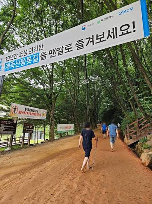
توان خاک رس در گردشگری
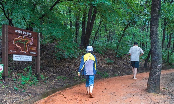
در سطح جهان خیلی روی مبحث خاک رس برای درمان کار شده است. امروز در تصاویری کره جنوبی را دیدم که "مسیر شفا" کنار کوهی تعبیه کرده بودند. همین مسیر شفا خاک رس را برای کشفرود و بسیاری از رودخانه های با مسیر خاک رسی دیگر ایران نیز میتوان تعبیه کرد. مسیر کشفرود سفالی است و مناسب گردشگری اکوتوریسمی از این قسم می باشد.
من خودم خاطره ویژه ای از خاک رُس دارم. در یکی از روزهای پاییزی، مثل امروز، من از خواب بیدار شدم و دیدم که یکی از انگشتانم ورم کرده است. به آن توجهی نکرده و گفتم که خوب میشوم. تا اینکه یک روز برنامه سفر به بندر چارک برای ما جور شد.
در تمام این مدت ورم دست همراه من بود و چرک کرده بود. من از پاره کردن و دست زدن به آن امتناع میکردم. برای سفر از مسیر کرمان رفتیم. مناطق توریستی کرمان تا بندر چارک را یکی پس از دیگری گذراندیم تا به مقصد بندر رسیدیم.
ساحل گرم و زیبای بندر چارک این موقع از سال خیلی دیدنی هست. محیطی طبیعی و آبی تمیز دارد که با یک نگاه میتوانی عمق مرجانی ساحل را نیز ببینی.
شبی که به بندر چارک رسیدیم هوا تا حدی خنک بود. از شرجی بندرعباس هم خبری نبود. هرچند بندر عباس زیبایی های خودش را داشت، ولی مقصد ما بندر چارک بود.
وقتی به ساحل رسیدیم از شکوه امواج و تمیزی ساحل نقره ای آن من در پارکی که آنجا بود به ذوق آمده و مشغول جمع کردن صدف ها شدم. کمی از صبح نگذشته بود که دیدم ورم انگشتم خوابیده و چرک آن هم رفته است.
چند روز بعد در اخبار دیدم که از آب دریا اسپری بینی تهیه کرده اند که خاصیت درمانی دارد. آن زمان فکر میکردم نمک های متنوع موجود در دریا بوده اند که دست من را به این سرعت خوب کرده اند.
نمک دریا خاصیت ضد انعقادی دارد، ولی امروز فکر میکنم چیزی بیشتر از فقط نمک های موجود در آن آب بود که دست من را بهبود داد. ساحل نقره ای چارک خاک منحصر به فردی داشت که خود به تنهایی خاصیت درمانی داشته است. خود خاک شنی و رسی آن نیز خاصیت آنتی باکتریال داشته است. به طور عملی، تمامی عناصر اصلی و فرعی مورد نیاز بدن را این آب و ساحل آن داشته و دست من را درمان کرده است.
اخیرا پزشکان برای رس هایی که نه فقط در اطراف سواحل یافت میشوند، بلکه در اطراف رودخانه و دریاچه ها را نیز مورد توجه قرار داده اند. آنها این رس ها را رسهای عمیق نامیده اند.
هرچند سواحلی مثل ساحل جزیره هرمز که رس شناخته شده سرخ منحصر به فردی دارد که نه تنها خاصیت غذایی دارد بلکه در لوازم آرایشی و بهداشتی نیز استفاده میشود، سایر رسها در طبیعت نیز خواص خود را دارند. زمانی که به ما توصیه می شود که میوه بخوریم، میگویند از انواع میوه های رنگی بهره ببریم که انواع ویتامین ها را دریافت کنیم. این در مورد خاک های رس نیز صادق است. در ایران، هم در همان ساحل هرمز و هم در نقاط دیگری تحت عنوان کوه های رنگی (آلاداغ) تنوع رس داریم. در جایی نوشته بود که رس های آذربایجان از الماس با ارزش تر هستند. مشابه این رس ها با درجه بندی غذایی را در آلاداغ مهنان خراسان شمالی نیز میتوان یافت.
من در رابطه با خاک رس کتاب جالبی خواندم به نام «خواص درمانی رس ها» نوشته دکتر رسول نوبری و دکتر علی محمدی. در این کتاب در صد صفحه خواص متعددی درباره خاک رس، و نحوه استخراج آن برای درمان بیان میشود.
___________________
There has been a lot of work on the topic of clay for treatment around the world. Today, I saw pictures of South Korea where they had installed a "healing path" on the side of a mountain. This same clay healing path can also be installed on the Kashafrud and many other rivers with clay paths in Iran. The Kashfrud path is made of clay and is suitable for this type of ecotourism.
I myself have a special memory of clay. On one of the autumn days, like today, I woke up and saw that one of my fingers was swollen. I ignored it and said that I would be fine. Until one day, a trip to the port of Charak was arranged for us.
During this whole time, the swelling of my hand was with me and it had become pus. I refused to tear it off or touch it. We took the Kerman route for the trip. We passed the tourist areas from Kerman to Charak one after the other until we reached the port.
Therapeutic Use of Clay
The warm and beautiful beach of Bandar Charak is very spectacular at this time of year. It has a natural environment and clean water that you can see the depth of the coral reef at a glance.
The night we arrived at Bandar Charak, the weather was somewhat cool. There was no sign of the sweltering heat of Bandar Abbas. Although Bandar Abbas had its own beauties, our destination was Bandar Charak.
When we arrived at the beach, I was delighted by the splendor of the waves and the cleanliness of its silver beach in the park there and started collecting shells. It wasn't long before morning when I saw that the swelling on my finger had subsided and the pus had also gone.
A few days later, I saw on the news that they had made a nasal spray from sea water that had therapeutic properties. At that time, I thought that it was the various salts in the sea that had healed my hand so quickly.
Sea salt has anticoagulant properties, but today I think that it was something more than just the salts in the water that healed my hand. The Silver Coast of Qarq had a unique soil that had healing properties on its own. Its sandy and clay soil itself also had antibacterial properties. In practice, this water and its shore had all the main and secondary elements needed by the body and it healed my hand.
Healing properties of clays
Recently, doctors have paid attention to clays that are found not only around the beaches, but also around rivers and lakes. They have called these clays deep clays.
Although beaches like the coast of Hormuz Island, which has a unique red clay known for its nutritional properties, but also used in cosmetics and hygiene products, other clays in nature also have their own properties. When we are advised to eat fruit, they say that we should take advantage of all kinds of colorful fruits to get all kinds of vitamins. This is also true for clays. In Iran, we have a variety of clays, both on the Hormuz Coast and in other places called the Colored Mountains (Aladag). It was written somewhere that Azerbaijani clays are more valuable than diamonds. Similar food-grade clays can also be found in Aladagh, Mahnan, North Khorasan.
The Power of Clays in Tourism
I read an interesting book about clay called "Therapeutic Properties of Clays" by Dr. Rasoul Nobari and Dr. Ali Mohammadi. In this book, in a hundred pages, numerous properties of clay are explained, and how to extract it for treatment.