Kashafrud river - رودخانه کشف رود
اینجا درباره رودخانه کشفرود ایران مینویسمKashafrud river - رودخانه کشف رود
اینجا درباره رودخانه کشفرود ایران مینویسمدرباره من
 از اونهام که می گم آدم بایست حرف خودشو بزنه، اما یاد گرفتم که هر حرفی رو تو جاش بزنم، اینجا، هرچی می خوام رو می گم
ادامه...
از اونهام که می گم آدم بایست حرف خودشو بزنه، اما یاد گرفتم که هر حرفی رو تو جاش بزنم، اینجا، هرچی می خوام رو می گم
ادامه...
رودخانه کن؛ گنجی گمشده در دل تهران
در بررسی نقشههای شهری تهران، متوجه رگهای آبیرنگ شدم که در میان خیابانها و بزرگراههای انبوه غرب تهران جاری بود. ابتدا تصور کردم شاید یک بزرگراه یا مسیر ترافیکی باشد که به رنگ آبی نمایش داده شده، اما پس از بررسیهای دقیقتر در چندین اپلیکیشن نقشه و مرور تصاویر ماهوارهای، مشخص شد که با رودخانهای روبهرو هستم که از حاشیه پارک ارم عبور میکند.
این رودخانه در منابع فارسی به نام رودخانه کن یا رود سولقان شناخته میشود و در نقشههای انگلیسیزبان اغلب بهاشتباه با عنوان Kan Creek معرفی شده است. در حالی که واژه creek بیشتر برای نهرها و جویبارهای کوچک بهکار میرود و به گستره و اهمیت زیستمحیطی این رودخانه پاسخ نمیدهد. با توجه به طول مسیر، دبی آب، و نقشی که در تأمین منابع آبی و فضای سبز تهران دارد، بیتردید شایسته است river نامیده شود تا شأن واقعی آن حفظ گردد.
رودخانه کن از ارتفاعات شمالغرب تهران، حوالی سولقان سرچشمه میگیرد و پس از گذر از روستاهای کن و سولقان، از کنار پارک ارم عبور میکند و در نهایت به سمت جنوب حرکت کرده و مسیر کهریزک را در بر میگیرد. این رودخانه بخشی از سیستم پیچیده رودخانههای تهران بهشمار میرود و با زیرشاخههای متعددی همچون رودخانه جاجرود و کند پیوند خورده است. همین شبکه آبی، بهویژه در گذشته، یکی از منابع حیاتی برای کشاورزی و آبیاری دشت تهران بوده و هنوز هم اهمیت زیستمحیطی و اجتماعی بالایی دارد.
در میان پلهای تاریخی رودخانه کن، پل زیبای قاجاری کن که در سال ۱۲۹۰ ساخته شد و در ۱۳۱۲ به دست حاج محمدعلی کنی مرمت شد، همچون یادگاری از تاریخ معماری تهران قد برافراشته است. این پل نهتنها نماد منطقه کن، بلکه بخشی از میراث فرهنگی پایتخت ایران است. در دهه ۱۳۵۰ نیز پلی مدرنتر برای عبور خودروها احداث گردید که هماکنون در کنار پل قدیمی استفاده میشود. با این حال بسیاری از پلهای دیگر این رودخانه همچنان در نقشهها و معرفیهای گردشگری ناشناخته ماندهاند و نیازمند مستندسازی و ثبت بهتر هستند.
افسوس که در حاشیه این رودخانه با وجود زمینهای سرسبز و پارکهای طبیعی، امکانات گردشگری مناسبی دیده نمیشود. رستورانها، کافهها و مسیرهای پیادهروی که میتوانند به رونق گردشگری منطقه کمک کنند، هنوز بهطور سیستماتیک توسعه نیافتهاند. این در حالی است که رودخانههای شهری در بسیاری از کشورها و حتی بهتر از آن، همین زاینده رود خودمان به قطبهای فرهنگی و توریستی تبدیل شدهاند و با معرفی صحیح و یکپارچه، میتوانند ارزش زیستمحیطی و اجتماعی بسیار بالاتری پیدا کنند.
تهران به عنوان پایتخت ایران، شایسته است شبکه آبی خود را با دقت بیشتری معرفی کند. همانطور که جاجرود بهعنوان یکی از شاخصترین رودخانههای ملی مطرح است، رودخانه کن نیز سزاوار توجه و معرفی در سطح ملی و بینالمللی است. نامگذاری استاندارد، احیای مسیرهای گردشگری، و حفظ اکوسیستم این رودخانهها میتواند الگویی برای سایر شهرهای ایران باشد و در نهایت هویت آبی و تاریخی کشور را تقویت نماید.
_____________________
While reviewing the city maps of Tehran, I noticed a blue streak running through the crowded streets and highways of western Tehran. At first, I thought it might be a highway or traffic route displayed in blue, but after closer examination in several map apps and reviewing satellite images, it became clear that I was facing a river that runs along the edge of Eram Park.
This river is known in Persian sources as the Kan River or Sulqan River, and is often mistakenly referred to as Kan Creek on English-language maps. While the word creek is mostly used for small streams and rivulets, it does not reflect the extent and environmental importance of this river. Given its length, water flow, and role in providing water resources and green spaces in Tehran, it undoubtedly deserves to be called a river in order to preserve its true dignity.
The Kan River originates in the northwest heights of Tehran, near Solqan, and after passing through the villages of Kan and Solqan, it passes by Eram Park and finally moves south and includes the Kahrizak route. This river is part of the complex system of rivers in Tehran and is connected to numerous tributaries such as the Jajroud and Kand rivers. This water network, especially in the past, was a vital source of agriculture and irrigation of the Tehran plain and still has high environmental and social importance.
Among the historical bridges on the Kan River, the beautiful Qajar Kan Bridge, built in 1911 and renovated in 1933 by Haj Mohammad Ali Kan, stands tall as a monument to the architectural history of Tehran. This bridge is not only a symbol of the Kan region, but also part of the cultural heritage of the Iranian capital. In the 1970s, a more modern bridge was built for the passage of vehicles, which is currently used next to the old bridge. However, many other bridges of this river remain unknown in maps and tourism introductions and need better documentation and recording.
Unfortunately, despite the lush green lands and natural parks, there are no suitable tourism facilities on the banks of this river. Restaurants, cafes, and walking paths that can help boost tourism in the region have not yet been systematically developed. This is while urban rivers in many countries, and even better, our own Zayandeh Rood, have become cultural and tourist hubs, and with proper and integrated introduction, they can gain much higher environmental and social value.
Tehran, as the capital of Iran, deserves to introduce its water network more accurately. Just as Jajroud is considered one of the most prominent national rivers, the Kan River also deserves attention and introduction at the national and international levels. Standard naming, revitalizing tourist routes, and preserving the ecosystem of these rivers can serve as a model for other cities in Iran and ultimately strengthen the country's aquatic and historical identity.
صبح بارانی که گرم شد
امروز صبح را با هوایی نسبتاً مرطوب آغاز کردیم. بوی باران در هوا پیچیده بود و اگر رفتوآمد خودروها کمتر بود، شاید همانطور که آسمان وعده میداد، باران هم میبارید. با طلوع آفتاب و افزایش تدریجی تابش خورشید، دما آرامآرام بالا رفت؛ بهگونهای که ساعت هشت صبح دیگر میشد گفت هوا واقعاً گرم شده است.
دمای هوا با شتابی چشمگیر بالا میرفت و حس و حال یک صبح نیمهبارانی را به فراموشی میسپرد. حوالی ساعت دو و نیم بعدازظهر گرما به اوج رسید. برای اطلاع از دمای کشفرود، تصمیم گرفتم دمای شهر توس را بررسی کنم. در جستجوی اولیه، با چند عدد متفاوت مواجه شدم و با توجه به دمای مشهد، حدس زدم حدود ۳۳ درجه باشد.
اما برای اطمینان بیشتر، سرچ را ادامه دادم و به وبسایتی خارجی و نسبتاً دقیق رسیدم که اطلاعات مفصلتری ارائه میداد. با کمال تعجب دیدم دمای توس را ۴۱ درجه ثبت کرده است. از شدت گرمایی که در فضا موج میزد، این عدد چندان هم غیرقابلباور به نظر نمیرسید. اما وقتی بیشتر دقت کردم، متوجه شدم این دما مربوط به شهر توس در ایالت ختلان تاجیکستان است.
شهر توس تاجیکستان در حاشیه رودخانه کفرنهان، که بهمراتب بزرگتر از کشفرود ماست، قرار دارد. بهدلیل وجود این رودخانه و رطوبت بیشتر، ممکن است گرمای بالای ۴۰ درجه در آن منطقه به اندازه اینجا آزاردهنده نباشد. بررسی بیشتر نشان داد آن سایت اساساً اطلاعاتی از توس ایران ارائه نمیداد.
کمی در مورد دلایل گرمای شدید شهر توس تاجیکستان جستجو کردم و دیدم این شهر با وجود موقعیت کوهستانی، احتمالاً تحت تأثیر جریانات هوایی ناشی از دریای مازندران و تغییرات آبوهوایی منطقه قرار میگیرد. حتی ممکن است موج گرما از خود منطقه آغاز شده باشد یا به واسطه سفرهای پرتعداد مردم تهران به شمال کشور و در نتیجه گرمتر شدن دریای خزر، به طور غیرمستقیم هوای منطقه تاجیکستان را هم تحت تأثیر قرار داده باشد.
جالب است بدانید شهر توس تاجیکستان فقط ۲۲ کیلومتر از مرز ایران فاصله دارد و شهری تاریخی محسوب میشود. این کشور با افغانستان مرز مشترک دارد و بهعنوان یکی از پناهگاههای مهم گونههای جانوری متنوع در جهان شناخته میشود.
______________
We started this morning with a relatively humid weather. The smell of rain was lingering in the air, and if there had been less traffic, perhaps it would have rained as the sky had promised. With the sunrise and the gradual increase in sunlight, the temperature slowly rose; so that by eight in the morning it could be said that the weather had really warmed up.
The temperature rose at a remarkable pace, making the feeling of a partly rainy morning forgettable. Around two and a half in the afternoon, the heat peaked. To find out the temperature of Kashafarud, I decided to check the temperature of Toos. In my initial search, I came across a few different numbers, and considering the temperature in Mashhad, I guessed it was around 33 degrees.
But to be more sure, I continued my search and came across a foreign and relatively accurate website that provided more detailed information. To my surprise, I saw that Toos had recorded a temperature of 41 degrees. Given the intensity of the heat that was radiating through the air, this number did not seem so unbelievable. But when I looked closer, I realized that this temperature was related to the city of Tus in the Khotlan province of Tajikistan.
The city of Tus in Tajikistan is located on the banks of the Kafr Nahan River, which is much larger than our Kashf Rud. Due to the presence of this river and higher humidity, the heat of over 40 degrees in that area may not be as annoying as it is here. Further investigation showed that the site basically did not provide information about Tus in Iran.
I did a little research on the reasons for the extreme heat in the city of Tus in Tajikistan and found that despite its mountainous location, the city is probably affected by air currents from the Caspian Sea and climate changes in the region. It is even possible that the heat wave started in the region itself or that it indirectly affected the weather in the Tajikistan region due to the numerous trips of people from Tehran to the north of the country and the resulting warming of the Caspian Sea.
It is interesting to know that the city of Tus, Tajikistan, is only 22 kilometers from the Iranian border and is considered a historical city. This country shares a border with Afghanistan and is known as one of the most important refuges for diverse animal species in the world.
کشفرود در کنار دیوار تاریخی توس
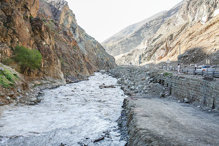
جویبار کوچکی که کشفرود از آن آغاز میشود از دل خاک بیرون میآید و بصورت جویبار کوچکی با جریانی آهسته از میان بوته زارها به بیرون ره میگشاید. این رود خروشان که ۲۹۴ کیلومتر از اعماق قرون سربرمیآورد کشفرود نام دارد.
کشفرود در حالیکه که از مزرعه و مرغزار میگذرد رنگ درمنه وحشی و افسنطین را قرض میگیرد و از نیروی زنده جویبارهای دیگری که به آن میپیوندند حیات مییابد.
هنگامی که بلوغ کامل یافت رودخانههای دیگر را به کام خود میگیرد و با جریانی هرچه گستردهتر برای رسیدن به مرز کشور بیتابی میکند این مشهورترین رودخانه شمال شرق کشور است.
رودها هر یک خاطره خود را دارند و خاطراتی که کشفرود دارد عمیق و گسترده است. این رودخانه ضربات تبر را به هنگام ساخته شدن اولین کلبههایی که با الوار درست میشد به یاد دارد. و صدای نرم ساروجی را که بر روی آجر ماله کشی میشد به یاد دارد. او لشکرکشیهای مغولها و شمشیر انتقام جوی یه آنها را به یاد میآورد.
شهرهایی که مسیر این رودخانه قرار میگرفتند به رغم بدرفتاری تاریخ بسیاری از نمونههای منحصر به فرد معماری خودشان را حفظ کردند. شهر توس با هارونیه در کنار دیوار تاریخی توس و رادکان با برج رادکان خود نمونهای از معماری گذشته خود را حفظ کردند. مشهد پس از آن با کال قره خان مسیر تاریخی رود را در کنار حرم امام رضا، امام هشتم شیعیان، به خاطر می آورد.
تزئینات پنجره برخی خانه های با چند سال ساخت یادآور برگ درختان غان بوده است.
هنر مردمی صنعتگران در زیباترین مناطق کشفرود به منصه ظهور رسید و چیزهایی که بدست صنعتگران ساخته شد شاهدی است بر جذابیت خارق العاده این ناحیه. در مسیر انحرافی زیرشاخه ای از کشفرود ژنراتورهای غول پیکر نیروگاه سیکل ترکیبی فردوسی قرار دارد. این نیروگاه انرژی مورد نیاز منطقه را با تاسیسات هیدروالکتریکی گوناگون تامین میکند.
آب کشفرود باشکوه از میان کوه ها و جنگلهای حفاظت شده، مزارع و مرغزارها و از سواحلی که خاطره انسان های عالیقدری را به همراه دارد جریان می یابد. در روستای پاژ نزدیک کشفرود حکیم ابوالقاسم فردوسی تولد یافت. کشفرود زادگاه بسیاری از عرفا، نویسندگان و دانشمندان ایرانی است، که در سراسر جهان شهرت دارند. پیر پالان دوز، امام محمد غزالی و خواجه نصیر الدین طوسی از جمله دانشمندان در مسیر کشفرود هستند.
خواجه نصیر طوسی برج رادکان را بنا نهاد. او رصد خانه مراغه را بعنوان بزرگترین کتابخانه دوران شکوه اسلامی ایران بنا کرد و دانشمندان زیادی را دور خود جمع کرد تا درباره نجوم و کیهان شناسی تحقیق کنند. از جمله کتاب های او زیج ایلخانی است. او ابزارهای ستاره شناسی دقیق تدارک دید که از جمله آنها میتوان به برج رادکان که در نزدیکی کشفرود و جای کوههای هزارمسجد است اشاره کرد
کشفرود ایستگاه های مطالعاتی متعددی در اطراف خود دارد. پرنده هایی که در کتاب های درسی تصویر آنها را میبینیم در نیزارهای کشفرود به وفور یافت میشود. کشفرود در کیلومترها راهی که طی کرده مرغزارهای بیشماری از جمله مرغزار رایکان را سیراب میکند و در نهایت به مرز افغانستان میرسد.
_____________
The small stream from which the Kashafrud begins emerges from the earth and flows slowly through the bushes. This roaring river, which rises 294 kilometers from the depths of centuries, is called the Kashfrud.
As it flows through fields and meadows, the Kashfrud borrows the color of wild sagebrush and finds life from the living force of other streams that join it.
When it reaches full maturity, it swallows other rivers and, with an ever-widening flow, it is eager to reach the country's border. This is the most famous river in the northeast of the country.
Rivers each have their own memories, and the memories of the Kashfrud are deep and extensive. This river remembers the blows of the axe when the first huts were built made of timber. And it remembers the soft sound of mortar being troweled on bricks. He remembers the Mongol campaigns and their sword of revenge.
The cities that lay along the river's course, despite the mistreatment of history, have preserved many unique examples of their architecture. The city of Tous with its Harunieh and Radkan with its Radkan Tower have preserved an example of their past architecture. Mashhad then commemorates the river's historical course with the Kal Qara Khan next to the shrine of Imam Reza, the eighth Imam of the Shiites.
The window decorations of some houses built a few years ago are reminiscent of birch leaves.
The folk art of artisans came to the fore in the most beautiful areas of the Kashafrud, and the things made by artisans are a testament to the extraordinary charm of this area. On a branch of the Kashafrud, there are giant generators of the Ferdowsi combined cycle power plant. This power plant supplies the energy needed by the region with various hydroelectric installations.
The magnificent Kashfrud flows through mountains and protected forests, fields and meadows, and along the banks that carry the memory of great people. In the village of Pazh near Kashfrud, the sage Abolghasem Ferdowsi was born. Kashfrud is the birthplace of many Iranian mystics, writers and scientists, who are famous all over the world. Pir Palandoz, Imam Muhammad Ghazali and Khwaja Nasir al-Din Tusi are among the scientists on the Kashfrud path.
Khwaja Nasir al-Din Tusi founded the Radkan Tower. He built the Maragheh Observatory as the largest library of the Islamic glory period of Iran and gathered many scientists around him to research astronomy and cosmology. Among his books is the Zij al-Ilkhani. He prepared precise astronomical instruments, among which we can mention the Radkan Tower, which is near Kashafrud and the site of the Thousand Mosque Mountains.
Kashfrud has several study stations around it. The birds we see in textbooks are found in abundance in the reed beds of the Kashfrud River. The Kashfrud River irrigates countless meadows along its many kilometers of path, eventually reaching the Afghan border.
کشفرود در تاریخ جنگهای ایران
کشفرود، رودخانهای است در استان خراسان رضوی، که در تاریخ جنگهای ایران به خصوص در شاهنامه فردوسی به عنوان محل نبرد سام نریمان با اژدها ذکر شده است. این رودخانه در حماسه ملی ایران، محل وقوع رویدادهای مهمی بوده و به عنوان نمادی از شجاعت و پهلوانی در برابر نیروهای اهریمنی شناخته میشود.
در شاهنامه فردوسی، کشفرود به عنوان محل جنگ سام نریمان با اژدها آمده است. این نبرد در نامه سام به منوچهر و در قالب داستانی حماسی روایت شده است.
کشفرود که رودخانه ای ۲۹۴ کیلومتری از کوههای قوچان در نزدیکی اترک سرچشمه میگیرد، در مسیرش از چناران و گناباد رد میشود و به شهر تاریخی توس میرسد. آثار به جای مانده از دیوار تابران توس در نزدیکی پل فردوسی کشفرود نشان از قدمت و تاریخ این رود باستانی دارد. این رود پس از گذر از پل فردوسی، پل شاهی بین خواجه ربیع و کلات را رد میکند تا در شرق مشهد در مرز افغانستان به هریرود بپیوندد.
توس، شهر تاریخی در نزدیکی مشهد، در دوران حمله مغول به ایران، به شدت آسیب دید. مغولها این شهر را به دلیل موقعیت استراتژیک و اهمیت آن، هدف قرار دادند. در این حمله، بسیاری از مردم توس کشته و شهر به ویرانه تبدیل شد. با این حال، بعدها توس بازسازی شد و حتی مدتی مقر فرمانروایان مغول نیز بود.
برخی از منابع تاریخی به این نکته اشاره میکنند که دیوار دوازده متری توس (تابران توس) که در گذشته به عنوان حصار شهر در کنار کشفرود عمل میکرده، در اثر حملات مغول و عوامل دیگر آسیب دیده و ارتفاع آن به شدت کاهش یافته است
پس از حمله مغول شهر توس که کشفرود روزگاری مرزهای آن را مشخص میکرد، چندان مورد توجه برای به سازی و بازسازی قرار نگرفت.
دوازده سال از تصویب الحاق توس به مشهد می گذرد و با توجه به نیاز مردم به ساخت و ساز، شاهد ساخت و سازهای غیرقانونی در منطقه هستیم.
________
Kashfrud is a river in Khorasan Razavi Province, which is mentioned in the history of Iranian wars, especially in Ferdowsi's Shahnameh as the site of Sam Nariman's battle with the dragon. This river is the site of important events in the Iranian national epic and is known as a symbol of courage and heroism against demonic forces.
In Ferdowsi's Shahnameh, Kashfrud is mentioned as the site of Sam Nariman's battle with the dragon. This battle is narrated in Sam's letter to Manouchehr and in the form of an epic story.
A 294-kilometer river, Kashfrud originates from the Quchan Mountains near Atrak, passes through Chenaran and Gonabad on its way and reaches the historical city of Toos. The remains of the Tabran Toos wall near Ferdowsi's Kashfrud Bridge indicate the antiquity and history of this ancient river. After passing through Ferdowsi's Bridge, the river passes the Shahi Bridge between Khajeh Rabi and Kalat to join Harirud in the east of Mashhad on the Afghan border.
Tus, a historic city near Mashhad, was severely damaged during the Mongol invasion of Iran. The Mongols targeted the city due to its strategic location and importance. In the attack, many of the people of Tus were killed and the city was reduced to ruins. However, Tus was later rebuilt and even served as the seat of the Mongol rulers for a time.
Some historical sources point out that the twelve-meter-high wall of Tus (Tabaran Tus), which once served as a city wall along the Kashafrud, was damaged and its height was greatly reduced by Mongol attacks and other factors.
After the Mongol invasion, the city of Tus, whose borders were once marked by the Kashfrud, did not receive much attention for development and reconstruction.
Twelve years have passed since the approval of the annexation of Tus to Mashhad, and given the people's need for construction, we are witnessing illegal construction in the region.
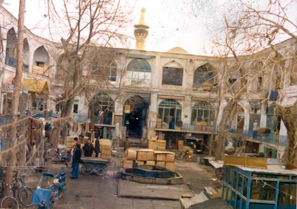
بازار سرپوشیده شهر توس کنار رودخانه
برای بازار سرپوشیده شهر توس که از جنوب به کشف رود متصل میشود به سراغ سایر بازارهای سرپوشیده کنار رودخانه در ایران میرویم.
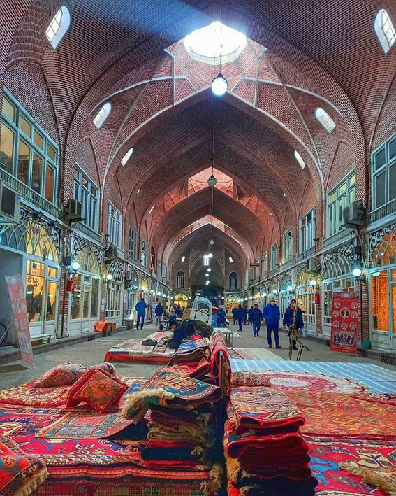
یک- بازار سرپوشیده تبریز که از سمت شمال به مهران رود متصل میشود و بخشی از بازار هم روی رود است
دو- بازار سرپوشیده جلفا که در نزدیکی رود ارس قرار دارد
از نظر معماری به بررسی معماری بازار سرپوشیده معروف به بازار رضا کنار حرم رضوی مشهد میپردازیم. این بازار در خیابان امام رضا و کنار حرم واقع شده است. معماری آن اسلامی است و با بازسازی که در آن صورت گرفته امروزی شده است.
بازار سرپوشیده جایی در میان تمدن ایرانی شناخته میشود. نمونه آن بازار سرپوشیده شهر شاهرود است. که ابتدا در میدانی که همه به آن متصل میشوند سرشاخه آن را میبینیم و سپس به نزدیکی دانشگاه صنعتی شاهرود میرسیم.
غرفه های متعدد فرهنگی وجه تمایز این بازارها با سایر بازارهای موجود در کشور است. بعلاوه محیط سبز اطراف این بازارها تنوع گیاهی بیشتر و درختان کهنسال دارد. این بازار ها پیوند انسان و طبیعت را بهتر حفظ میکنند.
طاقها و گنبدهای مقرنس بلند بازار سرپوشیده تبریز نمونه ای از معماری با در نظر گرفتن شرایط اقلیمی و محیط زیست است. سازههای آجری به هم پیوسته، آرایش مغازهها، کثرت تیمچهها، وجود انواع مشاغل و تعداد زیادی مدرسه و مسجد که در کنار سراهای بازرگانی قرار گرفتهاند، این بازار را نمونهای عالی از محیط تجارت و زندگی اسلامی و شرقی ساخته است.