Kashafrud river - رودخانه کشف رود
اینجا درباره رودخانه کشفرود ایران مینویسمKashafrud river - رودخانه کشف رود
اینجا درباره رودخانه کشفرود ایران مینویسمدرباره من
 از اونهام که می گم آدم بایست حرف خودشو بزنه، اما یاد گرفتم که هر حرفی رو تو جاش بزنم، اینجا، هرچی می خوام رو می گم
ادامه...
از اونهام که می گم آدم بایست حرف خودشو بزنه، اما یاد گرفتم که هر حرفی رو تو جاش بزنم، اینجا، هرچی می خوام رو می گم
ادامه...
حوضه آبریز کشفرود و اهمیت آن پس از قره قوم
پس از بررسی پوشش گیاهی کشفرود میرویم که آن را در میان حوضه های آبریز پایه مشخص کنیم.
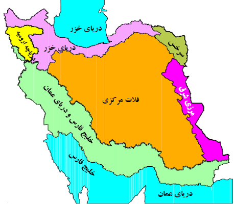
معرفی حوضه های آبریز ایران:
بر اساس تقسیم بندی هیدرولوژیکی دفتر مطالعات پایه منابع آب شرکت مدیریت منابع آب کشور ایران ، منابع آبی کشور به شش حوضه آبریز اصلی و سی حوضه فرعی به شرح ذیل تقسیم می شود .
1- حوضه آبریز اصلی دریای خزر : که شامل 7 حوضه آبریز فرعی به شرح ذیل می باشد :
1 – 1) حوضه آبریز رودخانه های تالش – مرداب انزلی
1- 2)حوضه آبریز رودخانه ارس
1- 3)حوضه آبریز رودخانه سفید رود
1- 4)حوضه آبریز رودخانه های بین سفید رود و هراز
1-5)حوضه آبریز رودخانه های بین هراز و قره سو
1-6)حوضه آبریز رودخانه های بین قره سو و گرگانرود
1-7)حوضه آبریز رودخانه اترک
2- حوضه های اصلی خلیج فارس – دریای عمان : که شامل 9 حوضه آبریز فرعی به شرح ذیل می باشد :
2-1) حوضه آبریز رودخانه های مرزی غرب
2-2)حوضه آبریز رودخانه کرخه
3-2)حوضه آبریز رودخانه کارون بزرگ
4-2)حوضه آبریز رودخانه جراحی – زهره
5-2)حوضه آبریز رودخانه حله
6-2)حوضه آبریز رودخانه مند
7-2)حوضه آبریز رودخانه های کل – مهران و جزایر خلیج فارس
8-2)حوضه آبریز رودخانه های بین بندر عباس - سدیج
9-2)حوضه آبریز رودخانه های بلوچستان جنوبی
3- حوضه آبریز اصلی دریاچه ارومیه : شامل یک حوضه آبریز فرعی با همین نام می باشد.
4- حوضه آبریز فلات مرکزی : که شامل 9 حوضه آبریز غرعی به شرح ذیل می باشد .
4-1) حوضه آبریز دریاچه نمک
4-2)حوضه آبریز گاوخونی
4-3)حوضه آبریز دریاچه های طشک- بختگان و مهار لو
4-4)حوضه آبریز کویر ابرکوه - سیرجان
4-5)حوضه آبریز جازموریان
4-6)حوضه آبریز کویر لوت
4-7)حوضه آبریز کویر مرکزی
4-8)حوضه آبریز اردستان ، ریگ زرین و سیاه کوه
4-9)حوضه آبریز کویر های در انجیر و ساغند
5- حوضه آبریز اصلی مرزی شرق : که شامل 3 حوضه آبریز فرعی به شرح ذیل می باشد
5-1) حوضه آبریز دق پترگان – نمکزار خواف
5-2) حوضه آبریز هامون مشکیل
5-3) حوزه آبریز هیرمند
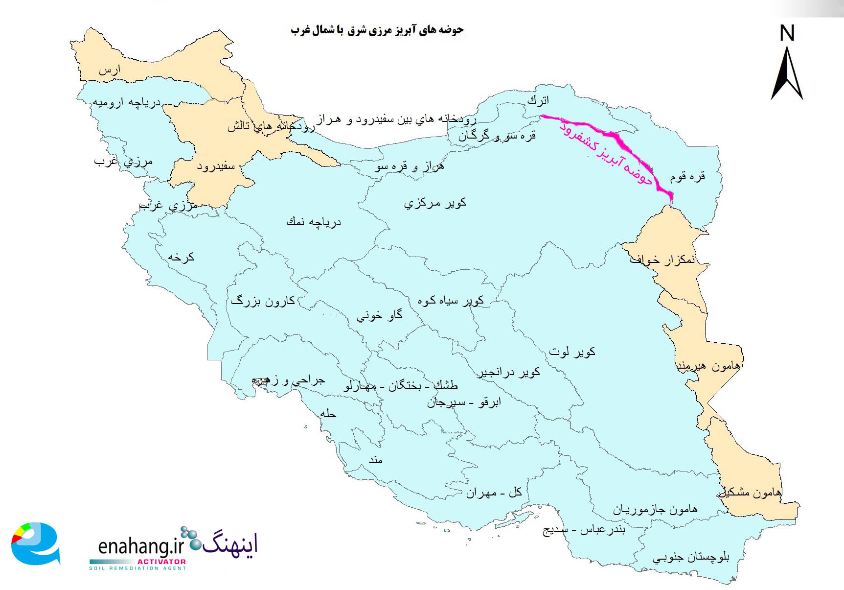
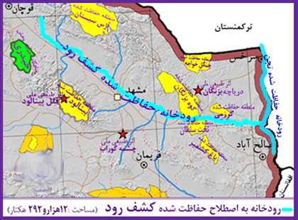
6- حوضه آبریز اصلی قره قوم (سرخس) : شامل یک حوضه آبریز فرعی با همین نام می باشد( شامل رودخانه های کشف رود ، هریرود یا قره قوم می باشد ) .
کشفرود رودی تاریخی است که تعدادی از انشعابات آن از کوه های هزار مسجد و انشعاباتی از آن از کوه های بینالود سرچشمه می گیرد. حوضه آبریز این رودخانه از جایی که سرچشمه اترک است، جایی در نزدیکی استان گلستان آغاز میشود.
حوضه آبریز این رودخانه با رودهای گرگانرود و قره سو در استان های گلستان و مازندران، از پوشش گیاهی هیرکانی برخوردار است.
رودخانه 294 کیلومتری کشفرود از غرب به شرق جریان دارد و از پل چشمه گیلاس، پل فردوسی و پل شاهی و پل خاتون ادامه مسیر میدهد تا به رودخانه هریرود و از آنجا به رود تجن بپیوندد. این رودخانه مانند هریرود در پایان مسیرش در کشور همسایه زهکشی میشود. منتها مسیر آن برعکس هریرود است. هریرود سرچشمه کوه های هندوکش و از شرق به غرب دارد، ولی کشفرود سرچشمه کوه های هزارمسجد و بینالود و از غرب به شرق دارد. هریرود کشور افغانستان را سیراب میکند، ولی کشفرود مانده است تا مدیریت شهری آن را از خشکرود خارج کند.
حوضه آبریز کشفرود زمانی اهمیت پیدا میکند که بدانیم در صد سال اخیر رودهایی مثل آمودریا که زمانی از تاجیکستان و ترکمنستان میگذشتند تا از خاک ایران به دریای خزر وارد شوند، با یکی از بزرگترین کانال های دنیا در زمان شوروی سابق تغییر مسیر داده و به دریاچه آرال میریخته است. آمودریا حوضه آبریز قره قوم و یا سرخس را تعریف میکرده است. مسیر این رودخانه اگر هم وجود داشته باشد، به پر آبی سابق نخواهد بود، و حتی دریاچه آرال هم سیرآب نمیکند. کانال های کشاورزی در مسیر آمودریا آن را نیز دچار تنش کرده است. در این هنگام حوضه آبریز کشفرود اهمیت پیدا میکند که آن را حفظ کنیم:
آب دریا را گر نتوان کشید / هم بقدر تشنگی باید چشید
بسیاری امیدوارند که رودهایی مثل آمودریا و هریرود دوباره از مسیر تایباد وارد ایران شوند، ولی تصاویر هوایی چیز دیگری را نشان میدهد:
من برای پیدا کردن سرچشمه هریرود از کلمه جمنازیوم هریرود استفاده میکنم. مشابه این کلمه که وارداتی از آلمان به هرات است، در فارسی ایرانی کمتر یافت میشود. ضمن اینکه اگر چشمه های ما خشک شوند، به دلیل کاربردهایی مثل کشاورزیست، ولی گویا در هرات و افغانستان آن را طور دیگری میبینند.
_______________________
After examining the vegetation of the Kashafrud River, we will identify it among the basic watersheds.
Introduction to Iran's watersheds:
Based on the hydrological division of the Water Resources Basic Studies Office of the Water Resources Management Company of Iran, the country's water resources are divided into six main watersheds and thirty sub-watersheds as follows.
1- The main basin of the Caspian Sea: which includes 7 sub-basins as follows:
1- 1) The Talesh-Anzali Marsh River Basin
1- 2) The Aras River Basin
1- 3) The Sefid Rud River Basin
1- 4) The River Basin between Sefid Rud and Haraz
1- 5) The River Basin between Haraz and Qara Su
1- 6) The River Basin between Qara Su and Gorgan Rud
1- 7) The Atrak River Basin
2- The main basins of the Persian Gulf - the Sea of Oman: which includes 9 sub-basins as follows:
2- 1) The Western Border River Basin
2- 2) The Karkheh River Basin
3- 2) The Greater Karun River Basin
4- 2) The Jarahi-Zohre River Basin
5- 2) The Hillah River Basin
6-2) Mand River Basin
7-2) Kal-Mehran River Basin and Persian Gulf Islands
8-2) Bandar Abbas-Sedij River Basin
9-2) Southern Balochistan River Basin
3- The main basin of Lake Urmia: It includes a sub-basin of the same name.
4- The Central Plateau Basin: It includes 9 sub-basins as follows.
4-1) Salt Lake Basin
4-2) Gavkhoni Basin
4-3) Tashk-Bakhtegan and Mahar Lu Lakes Basin
4-4) Abarkuh-Sirjan Desert Basin
4-5) Jazmorian Desert Basin
4-6) Lut Desert Basin
4-7) Central Desert Basin
4-8) Ardestan, Rig Zarrin and Siah Kooh Basin
4-9) Dar Anjir and Saghand Desert Basin
5- Main Eastern Border Basin: which includes 3 sub-basins as follows
5-1) Dagh-Petrgan-Namzar Khaf Basin
5-2) Hamun-Meshkil Basin
5-3) Hirmand Basin
6- Main Qara Qom Basin: includes a sub-basin with the same name (including the Kashf-Rood rivers , Harirud or Qara Qom).
The Kashfrud is a historical river that has a number of branches originating from the Hezar Masjid Mountains and some branches originating from the Binalud Mountains. The river's watershed begins near the source of Atrak, near Golestan Province.
The river's watershed, along with the Gorganrood and Qara Su rivers in Golestan and Mazandaran provinces, has Hyrcanian vegetation.
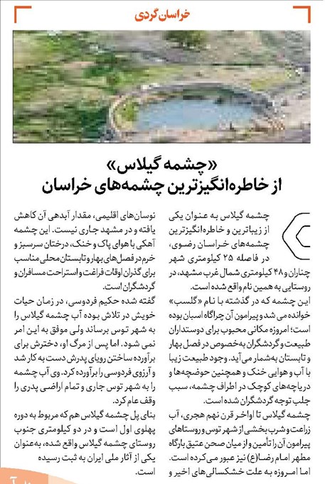
The 294-kilometer Kashfrud River flows from west to east and continues its route through the Cheshme Gilas Bridge, Ferdowsi Bridge, Shahi Bridge, and Khatoon Bridge to join the Harirud River and from there to the Tajan River. Like the Harirud, this river drains into a neighboring country at the end of its route. However, its route is the opposite of the Harirud. The Harirud originates in the Hindu Kush Mountains and runs from east to west, while the Kashfrud originates in the Hezar Masjid and Binalud Mountains and runs from west to east. Harirud irrigates Afghanistan, but Kashfrud is left to take its urban management out of Khoshkrud.
The Kashfrud watershed becomes important when we know that in the last hundred years, rivers like the Amu Darya, which once passed through Tajikistan and Turkmenistan to enter the Caspian Sea through Iranian soil, have changed their course with one of the largest canals in the world during the former Soviet era and flowed into the Aral Sea. The Amu Darya used to define the watershed of Karaganda (Qare Qum) or Sarakhs. If this river existed, its course would not be as watery as it once was, and even the Aral Sea does not irrigate. Agricultural canals along the Amu Darya have also strained it. At this time, the Kashfarud watershed becomes important to preserve:
If you can't draw the water of the sea / you must taste it as much as you are thirsty
Many hope that rivers like the Amu Darya and Harirud will enter Iran again through the Taybad route, but aerial images show something else:
I use the word Harirud Gymnasium to find the source of the Harirud. A similar word, which is imported from Germany to Herat, is rarely found in Iranian Persian. In addition, if our springs dry up, it is due to uses such as agriculture, but it seems that in Herat and Afghanistan they see it differently.
رودخانه کشفرود و گردشگری
به سن پدربزرگها، سیل آمد و افتاد توی سیلگیر که کال قرهخان بود و امتدادش به خیابان رازی میرسید. درواقع سیل از ملکآباد و کشفرود می آمد
پدربزرگ های ما اولین بازی غیر از خزینه را با آن سیل تجربه کردند.
کمی دنبال کال خیابان رازی که جستجو کنی باید نتیجه بگیری که از رودخانه کشفرود میومده تا زهکشی کنه.
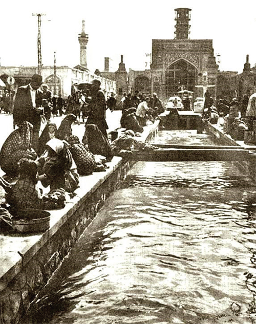
نگاه میکنی رئیس شرکتی گردشگری داستان همون سالی که سیل اومده رو تعریف میکنه، نام چشمه گیلاس، آرامگاه فردوسی و چند جای دیگه رو میاره و عجیب کشفرود رو نمی آره.
نگاه میکنی بلوار دندانپزشکان و فرهنگیان و غیره از مسیر دانشگاه آزاد و بعد دانشگاه فردوسی رو طوری با رودخانه پارک و دریاچه مصنوعی پر کرده که انگار هیچوقت بی آبادانی نمیشه. زمین های دندان پزشکان اگر شاهنامه فردوسی هم بود همینطور در موردشانه؟
آیا این اتفاقیه؟
وقتی روستای کشفرود به شهرک شهید سلیمانی تغییر نام میده،
وقتی کشفرود حفاظت نمیشه کسی اونو نمیخواد.
روستای چشمه گیلاس با کل گیلاس هایش خشک میشه. مگر چقدر جمعیتشه؟
کل بلوار شاهنامه فردوسی با زمین هایش مگر چقدر جمعیتشه؟
آرمیتاژ و هتل دیگه در مسیر سرچشمه مایان کشفروده و با دریاچه مصنوعی خشک نمیشه. اونوقت میگن به کشاورزی آبرسانی کردیم. کدوم آبرسانی؟
داریم میبینیم سرچشمه بالادست رودخانه گرفتین. حقابه شاهنامه رو باید بدین.
اون شرکتی که جمعیت یکباری بر آبادانیش حکمفرمایی میکنه، شرکت فاضلابه.
جستجو کردن درباره وضعیت کنونی رودخانه کمی جسارت میخواهد. مهندسی خاک و یا کشاورزی نبودم، ولی بقدری رودخانه های کشفرود و اترک مشکل دارند که نوشتههایم ضروریه.
کمی علمی بگیم:
اجرای کال جمع آوری آبهای سطحی این است که این مسیر از زیر بزرگراه پیامبر عبور میکند. به این دلیل که با وجود ترافیک امکان مسدود کردن این بزرگراه نبوده ، اجرای این پروژه از روش لوله رانی میسر میشه.
از مشکلات این مسیل: وجود معارضاتی مانند تاسیسات و فیبر نوری اجرای یک پروژه را مشکل کرده. این مسیل به زودی به پایان می رسد.
_____________________
When our grandparents were young, a flood came and fell into the floodplain that was Qara Khan's village and extended to Razi Street. In fact, the flood came from Malekabad and Kashfrud
Our grandparents experienced the first game with that flood other than Khazineh.
If you search a little for the village of Razi Street, you should conclude that it came from the Kashafrud River to drain it.
You look at the head of a tourism company telling the story of the same year that the flood came, mentioning the names of the Cherry Spring, Ferdowsi's tomb, and a few other places, but strangely not mentioning Kashfrud.
You look at the dentists' and educators' boulevards, etc., from the Azad University route and then Ferdowsi University, filled with a park river and an artificial lake as if it would never be developed. If Ferdowsi's Shahnameh were there, would the dentists' lands be the same?
Is this a coincidence?
When the village of Kashafrud is renamed to Shahid Soleimani Town
When Kashfrud is not protected, no one wants it.
The village of Cheshme Gilas with all its cherries is drying up. How many people are there?
How many people are there on Shahnameh Ferdowsi Boulevard with its lands?
The Armitage and other hotels on the route of the Mayan Kashafrud source will not dry up with an artificial lake. Then they will say that we have supplied water to agriculture. Which water supply?
We are seeing that you have taken the upstream source of the river.
The company whose development is once dominated by the population is the sewage company.
It takes a little courage to research the current state of the river. I was not a soil engineer or an agricultural engineer, but the Kashafrud and Atrak rivers are so problematic that my writings are necessary.
Let's be a little scientific:
The implementation of surface water collection is due to the fact that this route passes under the Prophet's Highway. Because it is not possible to block this highway due to traffic, the implementation of this project is possible using the pipe method.
Among the problems with this issue: The existence of obstacles such as facilities and fiber optics has made it difficult to implement a project. This problem will end soon.